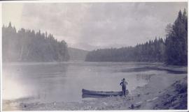
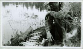
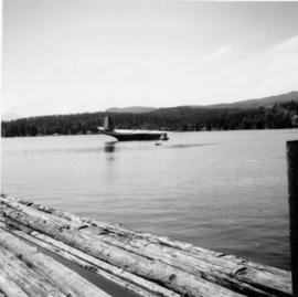
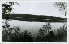
Handwritten caption above this photo reads: "Sumit Lake." Photograph depicts man sitting facing lake among branches of trees in foreground, forest on opposite shore reflected in water.
Handwritten caption beside this photo reads: "Earth Cut". Photograph depicts a man in distance at top of steep slope of man-made embankment, trees in background. Tracks made my machinery are visible in dirt of the cut.
Unidentified man stands beside a car, to left of piles. Tarp covers portion of lumber pile. Log fence and trees in background.
Photograph depicts unidentified man standing on boom of dragline crane, apparently without safety gear. Unidentified building and equipment can be seen in background against forest.
Photograph depicts a man with a helicopter at the location of the proposed powerhouse on Klemtu Lake.
Photograph depicts four horses, three dogs, and an unidentified man standing around a large pile of supplies in cleared area. Forest trees in background. Handwritten annotation on recto of photograph: "A camp on way to Shat-si-ji River:"
Photograph depicts a man kneeling by row of trout between two small logs on grassy bank of a water's shore. What appears to be the vertical handle of a knife is foregrounded at bottom of image. Handwritten caption below this photo reads: "Trout Fishing."
Photograph depicts an unidentified man, woman, and child sitting on a docked boat. Floating house and workshop visible behind boat while a step forested slope is visible in the background. Photographer’s stamp on verso reads: “W.E. Nicholson.”
Photograph depicts 2 men working in building project area, trees in background. Corresponding note on accompanying photo description page: "1. Building concrete forms for diesel engine footings. Oil tanks in background."
Photograph depicts track loader moving dirt in semi-cleared area, man and mountains in background. Corresponding note on accompanying photo description page: "3. Excavating for ore haul truck dump. Looking west".
Photograph depicts track loader moving dirt, mountains in background. Corresponding note on accompanying photo description page: "4. Excavating for ore haul truck dump with mill in background. Looking southeast."
Photograph depicts a small building in airport yard at Watson Lake. Corresponding note on accompanying photo description page: "2. Lock stave building. Recently used as a residence and in good condition."
Photograph depicts 9 men working on building speculated to be foundation for diesel engine. (See also items 2000.1.1.2.216 and 2000.1.1.2.217).
Photograph depicts mill building under construction, mountains in background. Corresponding note on accompanying photo description page: "Pictures taken July 3rd, 1952. 5. Mill. Truck Dump and concrete mixers in foreground. Taken from top of water tower and looking south."
Photograph depicts men working on plant site, mountains in background. Corresponding note on accompanying photo description page: "Pictures taken June 28th, 1952: (7) Power house construction. Oil tanks in background. Looking west."
Photograph depicts men working on buildings under construction, mountains in background. Corresponding note on accompanying photo description page: "Pictures taken July 3rd, 1952. 6. Truck Dump foreground. Power House background. Looking north."
Photograph depicts men building truck dump in foreground, building believed to be power house in background. Corresponding note on accompanying photo description page: "Pictures taken June 11th: (3) Framing water tank tower. Water well in foreground and tower timbers and oil tanks in background. Looking east." [Note believed to be incorrect.]
Image depicts a man and his family filling up their truck with gas at Manson Creek, B.C.
Image depicts the gas station at Manson Creek, B.C.
Image depicts the road to Manson Creek, B.C.
Photograph of the Prince Rupert wharf. Many vessels are docked next to small buildings along the water. Annotation on recto reads: "Prince Rupert BC."
Photograph depicts Margaret Hope, organizer of a 3 week tour. She was standing beside her husband's deluxe machine that was built from scratch. Taken on the CNR Okanagan line.
Margaret and Gus Lund stand on road, arms linked. Wood structure believed to be the box of a truck stands behind them on left. Power poles and forest in background behind road.
Handwritten annotations read: "At rest, after a rough passage of two days and a night from Massett, Queen Charlotte's Islands by canoe - W.H. Collison and Mrs. Collison with Indians from Masset"; "Archdeacon Collison Indian Canoe & Crew. Return from Queen Charlotte's Islands, Haida & Tsimshian Crew [...?]" Archdeacon and Mrs. Collison sit in centre of canoe.
Canoe with mast floats close to shore in foreground, mountains visible across river in background.
Handwritten annotation on verso reads: "Arch. W.H. Collison & wife with native friends en route up Skeena River."
Group of five unidentified men stand on shore to right of large dugout canoe, handling their rifles. Forest and snow-capped mountains stand on opposite shore in background.
Handwritten annotation on verso reads: "Mrs Collison (wife of Arch. Collison in Canoe en route to Hazelton B.C."
Photograph depicts one of the two Mars flying boats that were used as water bombers. Either "Hawaii Mars' or "Phillippine Mars."
Photograph depicts a "Master" tug after it underwent restoration in False Creek, Vancouver. It was under steam, and entering English Bay.
Photograph depicts man standing in CNR / GTP roundhouse at Endako. Typed annotation on verso reads: " Matt Caldwell in CNR/GTP roundhouse at Endako, pre-1950. Pre-WW1, Matt worked for Grand Trunk in Montreal as a boiler maker, moving to GTP in Edson. Served in WW1 with First Pioneers from P.G. Eventually promoted to Loco Foreman in Endako: retired c. 1950. Photo: May Caldwell Dockrill (daughter) & "Deeper Roots & Greener Valleys", published by Fraser Lake & District Historical society."
Typed annotation on verso reads: "Matt Caldwell on GTP/CNR turntable at Endako c. 1950. Pre-WW1, Matt worked as boiler maker for Grand Trunk in Montreal & later in Edson. He served in WW ! with First Pioneers from P.G. and after the war became (eventually) Loco Foreman in Endako: retired c. 1950. Photo: May Caldwell Dockrill (daughter) & "Deeper Roots & Greener Valleys", published by Fraser Lake & District Historical Society."
Photograph depicts Mayo Lumber Co. locomotive # 3 on display at Paldy, in central Vancouver Island.
Photograph depicts Mayo Lumber Co. 2 truck Shay locomotive # 3 on display at Paldy, between Duncan and Lake Cowichan, B.C.
Photograph depicts Mayo Lumber Co. locomotive # 3 on display at Paldy, between Duncan and Lake Cowichan, B.C.
Photograph depicts Mayo Lumber Co. Shay locomotive # 3 on display at Paldy, between Duncan and Lake Cowichan, B.C.
Image depicts the CN Station in McBride, B.C.
Image depicts the rear-end of the CN Station in McBride, B.C.
Image depicts the McBride CNR station.
Photograph depicts street in McBride, wood buildings and tent buildings on either side. Small businesses and restaurants line the left side of the street. Forest slash stands in newly cleared area in foreground. Railway tracks cross right foreground, hills visible in background. Annotation on verso of photograph reads: "MC.Bride, B.C.", handwritten on recto: "1914 [Bourchier?]"
Photograph depicts the McCulloch CPR depot located at mile 76.7 on the Carmi Subdivision, which is about 27 miles northeast of Penticton. The rear building is the passenger depot, which was painted blue inside. The view is looking north.
Photograph depicts the McCulloch CPR depot located at mile 76.7 on the Carmi Subdivision, which is about 27 miles northeast of Penticton. The building on the right is the passenger depot, which was last officially used in January 1964. The view is looking south on the downgrade.
Photograph depicts the McCulloch CPR depot located at mile 76.6 on the Carmi Subdivision., about 27 miles northeast of Penticton. The lifted switch at the right leads to a former "Y" that led east. The view is looking north.
Photograph depicts the McCulloch CPR depot at mile 76.6 on the Carmi Subdivision. The depot was painted blue inside. The last passenger train was seen 17 January 1964 and the last freight train on the 19 May 1973.