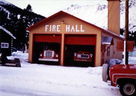
Photograph depicts two fire trucks semi-visible in garage with the sign "FIRE HALL". House and snowmobile can be seen in left midground, truck and power pole in right foreground. Mountains in background. Warning visible on front of trucks: "KEEP BACK 500m".
Photograph depicts large auditorium, seats filled with unidentified individuals (mostly children). Rounded stage in foreground, curtain on wall in background. This building was built in the late 1970s and belonged to the community's cultural society.
Photograph depicts mobile home modified for Cassiar winters (steeply sloped roof added). Yellow suburban parked in driveway in left foreground. Forest trees and mountainside visible in background. Sign reading "686" posted on tree in left foreground. Believed to be the home of Gerry Cooper.
Photograph depicts interior of church believed to be the All Saints Anglican Community Church at Cassiar, B.C. Table and pulpit in foreground, pews and door in background. Stained glass windows line both sides of the building.
Photograph depicts church believed to be the All Saints Anglican Community Church at Cassiar, B.C. Trees and fence in foreground, forest and mountain in background.
Photograph depicts group of children standing in front of diving board, watching a peer dive into water below. Group of swimmers visible in background below domed roof of pool.
Photograph depicts four orange and brown two-story buildings speculated to be bunkhouse residences. Blue car in foreground, forest and mountains in background.
Photograph depicts an unidentified man walking in front of orange and brown two-story building speculated to be bunkhouse residences. Second unknown individual can be seen unloading car in left foreground. Trees and mountains visible in background.
Photograph depicts trees and pickup trucks in front of long building speculated to be an apartment residence.
Street view photograph of several commercial buildings on an unidentified dirt road in Prince Rupert, BC. Foreground is primarily a shot of "Wallace's Dry Goods."
Image depicts the Columbus Hotel in Prince George, which was destroyed by a fire in 2008.
Members of the Collison family casually fishing from a large dock. Handwritten annotation on verso reads: "Collison family fishing from dock (Portland[?] Canal) {Max Elsie Henry Will Arthur Herbert}."
Image depicts College Heights, particularly along Gladstone Drive, in Prince George, B.C.
Image depicts an old, collapsing cabin somewhere in the Fort George Canyon Provincial Park, B.C.
Image depicts a collapsed shack somewhere near Woodpecker, B.C.
Image depicts a collapsed cabin in Quesnelle Forks, B.C.
Collection of four photographs of the Prince Rupert dry dock. Two images are the finished dry dock buildings. One image is of construction. Printed annotation on recto reads: "Before Launching Canadian Scottish Dry Dock, Prince Rupert BC."
Collection of four photographs of the Prince Rupert dry dock. Printed annotation on recto reads: "Dry Dock and Ship Building Plant, Prince Rupert BC."
Printed captions below images on recto read: “Souvenir of Prince Rupert BC; Prince Rupert June 1st, 1909; Prince Rupert Sept 1st, 1913; Public School; Water Front; City Hall; Haye Cove; Margaeto Fleet; Harbour Scene; SS Prince Marquitta at Prince Georg; Sunrise Prince Rupert Harbour; General Hospital; Gold Storage Place; Prince Rupert from Summit”.
Item is a photograph of the coffer dam built to isolate the construction site for the W.A.C. Bennett Dam.
Photograph depicts the Cobble Hill Station on the Esquimalt and Nanaimo Railway on Vancouver Island. The view is looking south.
Photograph depicts a general view of Coal Harbour in Vancouver, taken from its head in Stanley Park, looking east. The Bayshore Inn is shown on the extreme left of the image.
Photograph depicts the upper end of Coal Harbour, on the south shore looking southwest and taken from the dock of the Vancouver Shipyards Ltd.
Photograph depicts a general view of Coal Harbour in Vancouver, looking southeast and taken from Royal Vancouver Yacht Club premises. Photo shows the Bayshore Hotel on the extreme left.
Photograph depicts the west end of Coal Harbour looking south to West Georgia St. and Chilco-Gilford block beyond. The old pilings exposed at low tide.
Photograph depicts a general view of the upper and south shore section of Coal Harbour in Vancouver, B.C.
Photograph depicts a general view of the last 300 yards of the upper neck of Coal Harbour in Vancouver, B.C. The view is looking west and taken from the south side.
Photograph depicts the west end of Coal Harbour looking south to West Georgia St. and Chilco-Gilford block beyond. The old pilings exposed at low tide.
Photograph depicts a general view of Coal Harbour in Vancouver, looking southeast and south with Marine Building (downtown) on extreme left and Stanley Park (unseen) at extreme right.
Photograph depicts Canadian National Railway (CN) track crew sheds on Lulu Island at the south end of the Fraser St. road-vehicle bridge, near the intersection of #5 Rd. and Vulcan Way. The track is well used. The view is looking west.
Street view photograph of a large brick with a vehicle parked in front. Printed annotation on recto reads: "C.N.R. Station Prince George, B.C."
Photograph depicts the Canadian National Railway (CN) Port Mann depot.
Photograph depicts a CNR lifting bridge in Vancouver.
Photograph depicts the Canadian National Railway (CN) Kamloops Junction depot, facing east. The single line spur to Kamloops is about two miles long.
Photograph depicts the Canadian National Railway (CN) freight depot at Penticton, with a motor/rail tractor in the photo.
Photograph depicts the Canadian National Railway (CN) depot in Vernon, which is no longer used for passenger traffic.
Photograph depicts the Canadian National Railway (CN) depot at Spences Bridge, from a view looking southwest.
Photograph depicts the Canadian National Railway (CN) station at Clearwater, on the mainline between Kamloops and Tete Juane Cache Junction, about 75 miles north of Kamloops. The main trade is lumber. The view is looking south.
Photograph depicts a CNR bascule bridge across the upper waters of Victoria Harbour. The rest of the trackage had been removed, except for the bridge itself.
Image depicts a number of trains in the CNR train yard taken from River Road in Prince George, B.C. Map coordinates 53°54'51.5"N 122°43'29.6"W
Photograph depicts the Canadian National Railway (CN) station at Hope, B.C.
Photograph depicts the Canadian National Railway (CN) repair shops at Port Mann. The caboose is receiving a spray paint job.
Photograph depicts Canadian National Railway (CN) freight crossing Powell St. near Raymur Ave.
Photograph depicts the Canadian National Railway (CN) Chilliwack depot, looking north.
Image depicts the CN Building in Prince George, B.C.
Image depicts Upper Fraser residential area during demolition of town site. Map coordinates 54°06'51.6"N 121°56'26.3"W
Totem poles (crest poles?) stand in front of a line of houses. Blanketed canoes sit on beach in right foreground; forest in background.
Handwritten annotations on verso read: “Haida Encampment [crossed through with line]"; "Skidegate Queen Charlottes Islands / To illustrate Introduction / Introduction Trophies from a Song [Trail?] Page 1 Heading."
Photograph depicts large church to left of a tower structure. Power lines cross foreground, and other buildings can be seen in background.
Handwritten annotation on verso reads: "New Church Kincolith Nass River BC".