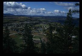
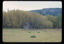
Image depicts a section of land on the east end of Francois Lake. The lake is visible in the distance.
Photograph depicts the Franz Colet residence at 743 9th Avenue West, Prince Rupert. This shack was the focus of the court case Colet v. The Queen (1981) after the City of Prince Rupert sanctioned trespassing on Colet's property and attempted to destroy his residence.
Image depicts a view of Fraser Lake.
Image depicts a few buildings in Fraser Lake, B.C.
Image depicts a group of children playing a yard in Fraser Lake, B.C.
Image depicts a row of houses in Fraser Lake, B.C.
Image depicts a couple of houses in Fraser Lake, B.C.
Image depicts the old Hudson Bay Trading Post with several unknown individuals present in Fraser Lake, B.C.
Image depicts the old Hudson Bay Trading Post in Fraser Lake, B.C.
Image depicts a cabin at Fraser Lake, B.C. which is labelled on the slide as an example of a "square log" dovetail joint.
Image depicts a bridge over the Fraser River in the Upper Fraser Canyon; possibly near Gang Ranch.
Image depicts a view of the Fraser River in Lillooet, B.C.
Image depicts a rail road bridge over the Fraser River, possibly somewhere in the Lillooet area.
Image depicts the small town of Fraser, B.C. Located on the Klondike Highway.
Handwritten caption above this photo reads: "Fred Youngstrom in [church shirt?]" Photograph depicts two men (Fred on left) standing on snow-covered road in front of car with a British Columbia license plate "93-650". A wood pile and long building with porch can be seen in background in front of forest trees. It is believed that this photo was taken at the camp in Summit Lake, B.C. (see item 2005.3.57).
Handwritten caption beside this photo reads: "Fred Youngstrom & Kitchen Staff. 1946." Photograph depicts Fred standing to right of three woman, a young girl, and a dog. The group is standing on the snow-covered front steps of a (kitchen?) building, lumber pile on far right. A large metal triangle is hanging behind Fred. It is believed that this photograph was taken at the camp at Summit Lake B.C. (see item 2005.3.57).
Photograph depicts a freight shed at the Nelson CPR depot. There is a terminal spur on the south side of the shed and road trucks on the north side. The road side of the main depot building can be seen in the left rear of the photo. The view is facing east.
Photograph depicts a freight shed located on the north side of the rail line and some 200 yards west of the Mission City CPR depot.
Image depicts a view of Prince George from Carney Hill.
Photograph depicts a tomb elevated over grassy area.
Handwritten annotation on image reads: "26. Front of Indian tomb."; on verso: "Upper Nass River."
Handwritten annotation on recto of photograph: "Front St. Hazelton in Winter. 12 J.W. [...]" Tree line, field, and hills in background. Handwritten annotation on verso of photograph: "Miss. Nellie [Nelville] G. Caranaugh".
Street view photograph taken at the intersection of Front Street and Carson Avenue. Several men are gathered at Cowan's Hardware store on the corner. Also visible in this photograph is the Cariboo Hotel (visible furthest to the left), and the British American Hotel which is partially visible behind the J.A. Fraser store. Printed annotation on recto reads: "On Front Street, Quesnel, B.C."
Image depicts the entrance of the Fulton River.
Image depicts a number of people standing at what appears to be a farm fishery [?] on the Fulton River.
Elevated street view of Fulton Street in Prince Rupert, BC. City Hall is in the left foreground. Hills and water are visible in the background. Printed annotation on recto reads: "Fulton St. Prince Rupert. B.C. W.W.W."
Photograph depicts a group of men, women, and children walking across beach towards water. Buildings visible on shore in left background.
Handwritten annotation on verso reads: "Funeral party - en route to boat Metlakatla BC (Taking body over to Grave Island".
Photograph depicts two log buildings in fenced area on lake shore, forest trees in background. A man can be seen standing near docking area and small boat pier extending into water in foreground. Handwritten annotation on recto of photograph: "Fur Farm Red Rock Lake". This location is believed to at mile 27, north of Summit Lake.
Image depicts Gang Ranch in the Upper Fraser Canyon.
Image depicts the general store and post office on Gang Ranch.
Image depicts the house of the owner of Gang Ranch.
Image depicts the Gang Ranch House in the Upper Fraser Canyon.
Image depicts Gang Ranch, with a sign warning that the area is patrolled by Range and Logging Patrols, in the Upper Fraser Canyon.
Image depicts the Upper Fraser Canyon from what appears to be the entrance to Gang Ranch.
Image depicts a wooden structure at Gang Ranch. It is possibility an elevated water trough.
Image depicts the Gang Ranch house.
Image depicts the Gang Ranch office.
Image depicts the sign to Gang Ranch, located in the Upper Fraser Canyon, with graffiti on it.
Image depicts a gas compression station located at Summit Lake, north of Prince George, B.C.
Image depicts a gathering of people for an uncertain event at an uncertain location, possibly in Lillooet, B.C. A few tents are set up in the picture.
Image depicts a gauging tower at Shelley, B.C.
Handwritten photo album caption below this photo reads: " 'General Duties' (G.D.) man at Officers' Quarters." Photograph depicts man in sweater vest and tie sitting in front of closed door with "R.C.A.F OFFICERS QUARTERS" printed on side. There is a broom on right, boots on left, and wood slat sidewalk in foreground.
Royal Canadian Air ForcePhotograph depicts young girl standing on front deck of "WANAMAKER'S GENERAL MERCHANDISE." Car visible on left, gas pump in front. Trees and neighbouring house visible in background. Handwritten annotation on recto of photograph: "ATLIN."
Photograph depicts a general store owned by Acton Kilby that was still operated by him at age 81. His family had moved from New Westminster in 1902 to run the store. The CPR depot originally connected direcly to the second floor of the building. Harrison Mills lay at the junction of the Harrison and Fraser Rivers and was an important site during steamboat days. Now it was a backwater of 3 dwellings beside the railway.
Slightly elevated view of an intersection surrounded by residential and business buildings in Prince Rupert BC. Printed annotation on recto reads: "General View Prince Rupert. B.C. W.W.W."
Photograph depicts the general view of the waterfront buildings between Burrard and Thurlow St., in Vancouver Harbour looking northwest from Burrard St. The Immigration Building is on the left and the "Princess of Vancouver" (C.P.R.) is in the middle distance.
Photograph depicts a general view, looking north, of Westview Harbour with the Powell River paper plant smoking in the background.
Handwritten photo album caption below this photo reads: "S/L. Geo Du Temple. #4 Unit N.W.S.R. Watson Lake." Photograph depicts man in uniform (wings medallion on left breast) standing in front of white doorway of log building. Ground in foreground covered with sticks and sawdust.
Royal Canadian Air Force