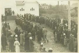
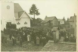
Showing 20493 results

Archival description
20493 results with digital objects Show results with digital objects
2009.21.39 · Item · 20 February 1938
Part of Thomas Crosby Mission Ship Photograph Collection

Clergy standing at the entryway to the newly reconstructed church as the choir walks towards them in two lines. The attendant congregation watches. The original Grace Methodist Church had been dedicated in the late 1800s and had its name changed to Grace United Church with Church Union in 1925; it was destroyed by fire, however, in 1931. Handwritten annotation on verso reads: "Opening of new church 1938."

2009.21.38 · Item · 20 February 1938
Part of Thomas Crosby Mission Ship Photograph Collection

Clergy standing at the entryway to Grace United Church speaking to a crowd gathered to witness the opening of this newly reconstructed church. The original Grace Methodist Church had been dedicated in the late 1800s and had its name changed to Grace United Church with Church Union in 1925; it was destroyed by fire, however, in 1931. Handwritten annotation on verso reads: "Opening of new church 1938. The left hand row of people with the white collars were the P.S. Choir. The right hand row was the band & Chair from Metlakatla, Alaska."

2000.13.1.41 · Item · 1967
Part of Ray Williston fonds

Item is a photograph of officials attending the June opening of the Crestwood Forest Industries pulp mill in Cranbrook, until that time the only pulp mill built without benefit of a Pulp Harvesting Area (PHA) license to assure timber supply. Mr. Williston is on the left.

Open Pit
2012.13.1.50.093 · Item · [1978?]
Part of J. Kent Sedgwick fonds

Image depicts an open mining pit at an uncertain location; it is possibly Gibraltar.

Open Field in Giscome
2012.13.1.87.069 · Item · [between 1975 and 1995]
Part of J. Kent Sedgwick fonds

Image depicts a field in Giscome, B.C. On the right side of the image, in the background, is a grey strip that appears to be a mine, possibly the quarry at Eaglet Lake in Giscome, B.C. Map coordinates 54°03'52.9"N 122°22'10.0"W

Open Field in Giscome
2012.13.1.87.068 · Item · [between 1975 and 1995]
Part of J. Kent Sedgwick fonds

Image depicts a field in Giscome, B.C. On the right side of the image, in the background, is a grey strip that appears to be a mine, possibly the quarry at Eaglet Lake in Giscome, B.C. Map coordinates 54°03'52.9"N 122°22'10.0"W

Open Field in Giscome
2012.13.1.87.163 · Item · [between 1975 and 1995]
Part of J. Kent Sedgwick fonds

Image depicts an open field and Giscome, B.C. in the background. Map coordinates 54°03'52.9"N 122°22'10.0"W

Open Cab Truck
2005.3.62 · Item · [ca. 1946]
Part of John Hart Highway Photograph Collection

Handwritten caption beside this photo reads: "1500wt 4x4". Photograph depicts small open cab truck with tire chains. Forest and unidentified buildings in background. A second vehicle is semi-visible on far left, as well as a pile of logs on far right.

On the way to the Peace
2002.7.1.78 · Item · Sept. 1921
Part of H.G.T. (Harry) Perry fonds

Handwritten annotation on recto: "On way to Peace, 1921". Photo depicts Harry Perry sitting by a campfire with two unidentified men. Photo may have been taken near Brennan's Flats where gold was being dredged from the Peace River.

2004.5.1.35 · Item · ca. 1914
Part of Fort Fraser historical photograph collection

Typed caption glued to album page directly below photograph reads: "17. On the way to Fort Fraser by auto." Photograph depicts a group of men standing, and one on horseback, around an automobile packed with luggage of all shapes. Photographer: Dominion Stock & Bond Corporation.

On the way to Fort Fraser
2004.5.1.09 · Item · ca. 1914
Part of Fort Fraser historical photograph collection

Typed caption glued to album page directly below photograph reads: "35. On the way to Fort Fraser." Photograph depicts six men in overcoats and hats sitting in an automobile parked at curbside. Photographer: Dominion Stock & Bond Corporation