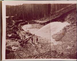
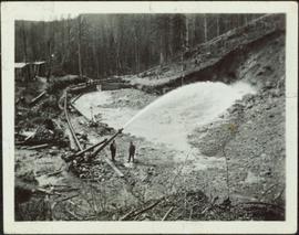
Showing 20493 results

Archival description
20493 results with digital objects Show results with digital objects
Placer mining in Hixon, BC
2007.17.1.5 · Item · [ca. 1933]
Part of James Joseph Claxton Photograph Collection

Photo is adhered to paper backing, upon which handwritten annotation on recto reads: “Placer mining Hixon B.C. Hungry 30ies. This picture taken on top of hill across from Quesnel Quartz Mine maybe 800 ft west of Quartz taken approx 45 yrs ago (1933) 1978.12.19”

Placer Mining Hixon, B.C.
2007.17.1.1 · Item · 1933
Part of James Joseph Claxton Photograph Collection

Two men stand below a large upright hose that is spraying a powerful stream of water against the side of a rocky hillside. Annotation on verso of photograph states: "Placer Mining Hixon (Hungry Thirties) This picture taken on top off Hill Across from Ques. Qarts. Maybe 800 Ft. west of Quarty There pictures taken approx 45 years ago Your friend(?) Box 156 Squamish B.C. Dec. 19/78"

2009.7.1.150 · Item · [ca. 1878 - ca. 1915]
Part of Archdeacon W. H. Collison fonds

Photograph features a steep cliff across water, rocky shore in foreground.

Handwritten annotation on verso reads: "Up the 'Big Creek' at Kincolith B.C. Rock face called 'the place of echoes' by the Indian people."

Pit, West Peak, & Plant
2000.1.1.3.13.61 · Item · [ca. 1980]
Part of Cassiar Asbestos Corporation Ltd. fonds

Photograph depicts a portion of the Cassiar pit in right foreground. Crushing plant visible to left of pit, West peak visible in right background. Mountain range can be seen in distance.

Pit & Crushing Plant
2000.1.1.3.13.60 · Item · [ca. 1975]
Part of Cassiar Asbestos Corporation Ltd. fonds

Photograph depicts a portion of the pit in foreground at the Cassiar mine. Crushing plant visible in centre below base of West peak. Footwall road in midground, mine valley in background. Building near trucks at top of pit was called the "shifter shack," where crews were relieved or dropped off for work.

Pipe yard
2013.6.36.1.117.02 · Item · [Nov. 1991]
Part of David Davies Railway Collection

Photograph depicts a pipe yard of West Coast Gas Transmission. Two large pipes had gotten away and rolled onto the railway.

2013.6.36.1.077.05 · Item · 2 Sept. 1970
Part of David Davies Railway Collection

Photograph depicts Pioneer Sash and Door Company Ltd. Davies suggests that it may have been the same as S.C. Smith Ltd., which commenced operating in Vernon in 1883. In the early days, products were verandah posters, balusters, and fancy trim. Most products were sent to the U.S. Most of the fancy trim in early north Okanagan homes came from this plant. In 1972, its main output was cedar panelling for Florida.

Pineview
2012.13.1.3.144 · Item · [199-?]
Part of J. Kent Sedgwick fonds

Image depicts Pineview on Buckhorn Lake Road, Prince George, B.C.

Pineview
2012.13.1.3.145 · Item · [199-?]
Part of J. Kent Sedgwick fonds

Image depicts Pineview on Buckhorn Lake Road, Prince George, B.C.

Pineview
2012.13.1.3.146 · Item · [199-?]
Part of J. Kent Sedgwick fonds

Image depicts Pineview on Buckhorn Lake Road, Prince George, B.C.

2000.19.2.118 · Item · 29 Aug. 1927-26 Sept. 1927
Part of Prentiss Gray Collection

Photograph depicts Pine River winding between forested hillsides. Several islands covered with trees are located in the middle of Pine River. The river leads to Kinuseo Falls also known as Kinoosao Falls.

Pine Pass
2012.13.1.91.31 · Item · Nov. 1978
Part of J. Kent Sedgwick fonds

Image depicts an unidentified individual standing near a drop-off in the Pine Pass between Alberta and British Columbia. The sign behind the individual reads: "Pine Pass - 2,868 FT. Here the great barrier of the Rock Mountains is breached by the lowest highway pass. Once the remote route of the trapper, it now links the commerce of the north and markets of the south. The John Hart Highway was completed in 1952 and followed by the P.G.E. in 1958. Gas and oil lines also take advantage of this convenient natural feature."

Pine Pass?
2012.13.1.73.03 · Item · Aug. 1979
Part of J. Kent Sedgwick fonds

Image depicts a view of what is possibly the Pine Pass located near the Murray Ridge.

Pine Centre Mall
2012.13.1.3.111 · Item · 12 Oct. 1989
Part of J. Kent Sedgwick fonds

Image depicts Pine Centre Mall in Prince George, B. C. Map coordinates 53°53'53.2"N 122°46'36.4"W

Pile trestle
2004.8.1.72 · Item · 9 June 1939
Part of Alexander Manson mining collection

Photograph depicts a wooden pile trestle that leads through a wooded landscape. Annotation on recto of photograph reads: "Pile tressle upper end. Sec.#1. Bents 12" centers - 3 only 12" piled driven to refusal; caps 10" x 12" "