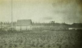
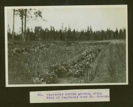
Typed caption glued to album page directly below photograph reads: "20. Vegetable Garden growing every kind of vegetable near Ft. Fraser." Photograph depicts rows within a vegetable garden. Photographer: Dominion Stock & Bond Corporation.
Typed caption glued to album page directly below photograph reads: "12. Fort Fraser, Rich Farm-land." Photo depicts a dirt road running through a hilly landscape. Photographer: Dominion Stock & Bond Corporation.
Photograph depicts a view of the rocky shores of Fort George Canyon from the deck of a steamship.
Photograph depicts a view of the swirling waters of Fort George Canyon from the deck of a steamship.
Photograph depicts a view of Fort George Canyon.
Photograph depicts a view of Fort George Canyon from the shore. A steamship is in the centre of the river.
Image depicts Fort George Canyon.
Photograph depicts misty waters and small islands in the river.
Photograph depicts Fort George Canyon from a lofty view. A small building is situated on the river's edge.
Overlooking the Fraser River after the spring thaw. Handwritten annotation on recto of photograph: "Ft. George Canyon Red Rock B.C. Apr 56".
Photograph depicts the early settlement of Fort George. The buildings to the left of the fence are believed to be owned by the Hudson's Bay Company. The land to the right of the fence belonged to the Fort George Reserve, the home of today's Lheidli T'enneh Band who relocated to a reserve at Shelley when this reserve was sold in 1912. Handwritten annotation on verso and recto of this photograph reads: "Fort George from opposite side of Fraser River".
Fire at the Fort George Hotel devastated the entire block. Harry Perry's Tailor shop was right across the street from the fire. Handwritten annotations on recto: "Fort George Hotel Fire; Nov. 13, 1914"
Wide angle photograph of a sparsely forested area with Prince/Fort George in the background. Printed annotation on recto reads: "Fort George, B.C."
Image depicts the Fort George Park. Map coordinates 53°54'30.2"N 122°43'57.4"W
Image depicts the Fort George Par, which was renamed Lheidli T'enneh Memorial Park in 2015. Map coordinates 53°54'30.2"N 122°43'57.4"W
Image depicts an aerial view of Fort George Park.
Image depicts the Fort George Regional Museum in Prince George, B.C.
Image depicts the Fort George Regional Museum (now known as The Exploration Place) in Prince George, B.C. Map coordinates 53°54'18.6"N 122°44'09.8"W
Image depicts the Fort George Regional Museum in Prince George, B.C. Map coordinates 53°54'18.6"N 122°44'09.8"W
Six men stand on boardwalk in front of theatre.
Possibly Fort Graham log building surrounded by a fence
Annotation on verso: "Fort Grahame mail boat at 20 mile". Photo depicts a mailboat pulling along side another boat along a rocky shoreline. Two men, a woman and a child are on board while one man and two dogs are on the shore.
Image depicts a church in Fort St. James, B.C.
Image depicts an old log building in Fort St. James; the sign on it reads "Clerk's Living Quarters, Later Used as Fort St. James First School."
Image depicts a historic building in Fort St. James, B.C.
Image depicts the interior of a historic building in Fort St. James, B.C.
Image depicts the Hudson's Bay Company historic site in Fort St. James, B.C.
Image depicts the historic Hudson's Bay Company office in Fort St. James, B.C.
Image depicts the interior of the historic Hudson's Bay Company office in Fort St. James, B.C.
Image depicts the Hudson's Bay Company Trading Post at the historic site in Fort St. James, B.C.
Image depicts an old shack on stilts in Fort St. James, B.C.
Image depicts Stuart Lake in Fort St. James, B.C.
Image depicts a partially frozen lake, most likely Stuart Lake in Fort St. James, B.C.
Image depicts a lake, possibly Stuart Lake in Fort St. James, B.C.
Image depicts the interior of the historic Hudson's Bay Company Trading Post, with several unknown individuals present, in Fort St. James, B.C.
Image depicts the interior of the historic Hudson's Bay Company Trading Post in Fort St. James, B.C.
Image depicts the interior of the historic Hudson's Bay Company Trading Post, with several unknown individuals present, in Fort St. James, B.C.
Image depicts the old Trading Outpost in Fort St. James, B.C.
Image depicts a view of Fort St. John, B.C.
Image depicts an area of forests and fields somewhere near Fort St. John, B.C.
Image depicts a view of Fort St. John, B.C.
Image depicts two unidentified individuals in hard hats leaning against the railing of a large, open space inside an unknown concrete structure. It is possibly located in Fort St. John, B.C.
Image depicts a group of unidentified individuals in a greenhouse, possibly somewhere in Fort St. John, B.C.
Image depicts several unidentified individuals exiting a church made of logs, possibly in Fort St. John, B.C.
Image depicts several unidentified individuals inside of a church made from logs, possibly located in Fort St. John, B.C.