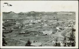
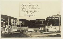
Image depicts Prince George, with the picture looking North-Northeast from University Way.
Image depicts an uncertain street in Prince George, B.C.
Image depicts Brunswick Street at 3rd Ave in -35 degree weather. Map coordinates 53°55'03.0"N 122°44'51.7"W
Image depicts 3rd Ave at Brunswick Street in -35 degree weather. Map coordinates 53°55'03.0"N 122°44'51.7"W
Image depicts the Courthouse in Prince George, B.C.
Image depicts Prince George from the view of Peden Hill.
Item is a photograph of Prince George taken from the air, looking east with the Cameron Street Bridge in the foreground.
Image depicts a Prince George residential area from the viewpoint of the Ginter Property.
Image depicts the Prince George Hotel.
Photograph features the hotel on George Street, Prince George BC. Handwritten annotation on verso of photograph reads: "Xmas [1948?]", on recto: "From Mr. & Mrs. Fask Douglas." Poem on verso reads: "May Christmas Joy And all its cheer Be yours throughout A good New Year".
Postcard image depicts streetview looking west along 3rd Ave in Prince George, B.C. Storefronts and period automobiles are visible. Handwritten annotation on photographic negative, now visible along bottom of print image reads: "3rd Ave, Prince George B.C. Looking West. HND 41".
Image depicts the Prince George Public Library (Bob Harkins Branch). Map coordinates 53°54'43.1"N 122°44'56.4"W
Image depicts the Prince George Public Library (Bob Harkins Branch). Map coordinates 53°54'44.6"N 122°45'01.7"W
Image depicts an aerial view of a Prince George residential section between Highway 97, Carney Street and 10th Ave looking north. Map coordinates 53°54'54.0"N 122°46'00.4"W
Image depicts the Prince George Sawmill from the Northwood Bridge.
Image depicts Prince George Sawmill taken from across the Nechako River looking southwest. Map coordinates 53°56'00.0"N 122°44'29.7"W
Image depicts the Prince George welcome and population sign, with a population of 71,086. Map coordinates 53°53'52.0"N 122°46'08.7"W
Image depicts the Four Seasons Leisure Pool, and the Centennial Fountain in Prince George, B.C. Map coordinates 53°54'48.5"N 122°44'49.2"W
Photograph depicts the major buildings and streets of the town. Sloped cutbank visible across the Nechako River in background. It is believed that this photograph was taken from Connaught Hill. Handwritten annotation on verso of photograph reads: "PRINCE GEORGE, B.C."
Wide angle photograph of a forested area with Prince George in the distance. Printed annotation on recto reads: "Prince George, B.C. 1924."
Image depicts a view of Prince Rupert, B.C.
Image depicts the Bank of Nova Scotia located on "Besner Block" in Prince Rupert, B.C.
Image depicts the City Hall of Prince Rupert, B.C.
Image depicts a view of the downtown core of Prince Rupert, B.C.
Image depicts numerous buildings and a small dock somewhere in Prince Rupert, B.C. One of the buildings is labelled "Fishermen's Supply."
Image depicts numerous houses on the cliff-sides in Prince Rupert, B.C.
Image depicts numerous houses in Prince Rupert, B.C.
Image depicts several houses in Prince Rupert, B.C.
Image depicts numerous houses in Prince Rupert, B.C.
Image depicts the main street of Prince Rupert, B.C.
Image depicts an old building on the main street of Prince Rupert, B.C. Only half of the business name is visible: "Skeena Color [sic]."
Image depicts the rail yards in Prince Rupert.
Image depicts a view of what is possibly a shipping yard in Prince Rupert, B.C. The slide is labelled "superport."
Postcard featuring a car parked outside of Prince Rupert City Hall. Handwritten annotation on verso reads: "Alex Hall, Glyn P.O., Victoria, B.C. Prince Rupert, Billy S."
Ground level view of the Prince Rupert court house. Printed annotation on recto reads: "Court House." Handwritten annotation on recto in blue ballpoint pen reads: "Prince Rupert BC." Handwritten annotation on verso reads: "Hi Folks. Guess you've heard the good news by now. Well we've finished our cruises for this year so its home again finally to be with Marge and Janet. Will write shortly. Love Derek." Postcard is addressed to: "Mr & Mrs J.J. Oliver Box 666 Yarmouth N.S." Verso affixed with a three cent Canadian stamp. Postmark on verso reads: "Prince Rupert BC Oct 23 130 PM 1952."
Overhead view of the dry dock in Prince Rupert, BC. Printed annotation on recto reads: "Prince Rupert Dry Dock."
Photograph depicts the multi-level Prince Rupert hospital with trees and shrubbery in the foreground. Annotation on recto of photograph states: "Prince Rupert Hospital W.W.W. Photo"
Side view of the Prince Rupert in on Prince Rupert Road. Printed annotation on recto reads: "Prince Rupert Road, showing Prince Rupert Inn."
Wide angle photograph of Prince Rupert sometime during the winter. There is snow on the ground and a marge mountain range is visible in the background. Annotation on recto reads: "Prince Rupert looking East from Waterworks J.D.A Pho 5/2."
Image depicts a view of the port in Prince Rupert, B.C. The slide is labelled "superport."
Street view of Prince Rupert storefronts. A high cliff can be seen in the background with several large houses perched atop it. Printed annotation on recto reads: "Prince Rupert Residences on the Cliff which runs thru the Heart of the City." Handwritten annotation on verso reads: "8-18-24 I am still on the go but heading for home when [illegible] to be by Soft cot. Here seen some great scenery in Canada. Trains by boat to-night for Vancouver. Nan felt better. Love for all Chas[??]." Handwritten address on verso reads: "Mrs. Friderich Eley R [illegible] 3 Santa Ana Calif. U.S.A." Postmark stamped on verso reads: "Prince Rupert BC. 10 PM Aug 18 1924."
Photo of entire ship building plant, including several vessels in the foreground. Hills are visible in the background. Annotation on recto reads: "Prince Rupert Ship Repair and Ship Building Plant. Prince Rupert BC. Frank E Kirby, William T Donnelly, Engineers. 17 Battery Place. NYC."
Street level view of the United Church in Prince Rupert BC. Printed annotation on recto reads: "Photo J.W. United Church Prince Rupert."
Lofty view of the buildings along the Prince Rupert wharf with workers unloading a vessel. Water and mountains can be seen in the background. Printed annotation on recto reads: "Prince Rupert Wharf."
Photograph of the Prince Rupert wharf. A small vessel is docked, and a large tree is in the foreground. Annotation on recto reads: "Prince Rupert Wharf & Harbor. Allen Photo."
Photograph of the Prince Rupert wharf. A small vessel is docked, and a large tree is in the foreground. Annotation on recto reads: "Prince Rupert Wharf & Harbor. Allen Photo." Handwritten annotation on verso reads: "766[?]"