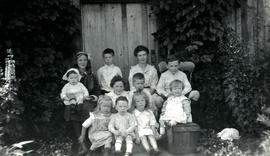
The group poses in front of a wood door, ivy on either side.
Handwritten annotation on verso reads: "Family group at Kincolith 1917 / Mimi [Muriel] with Colin, Bill, Katie, Jack / Art, Reg / Winnie [Marion Winnifred], Hugh, Joyce, Don".
The group poses in front of a wood door, ivy on either side.
Handwritten annotation on verso reads: "Family group at Kincolith 1917 / Mimi [Muriel] with Colin, Bill, Katie, Jack / Art, Reg / Winnie [Marion Winnifred], Hugh, Joyce, Don".
Photograph depicts group of buildings at Grande Prairie airstrip. The foremost building has the sign "YUKON SOUTHERN" on its roof, and the tower and admin building can be seen behind. Power poles, large trucks, and other large unidentified machinery are lined up in background on right.
Royal Canadian Air ForcePhotograph depicts building with small second story attached, and a tall red and white pole in front. Signal tower and power poles in background on right, semi-trailer in background on left. A man in uniform can be seen in the far right sitting on a small staircase on wheels. Small unidentified buildings and miscellaneous shop supplies in background. Handwritten photo album caption beside this photo reads: "Grand Prairie Tower and Adm. Bldg."
Royal Canadian Air ForceImage depicts a row of houses in Granduc, near the Granduc Mine and located north of Stewart, B.C.
Image depicts a row of boarded up houses in Granduc, near the Granduc Mine and located north of Stewart, B.C.
Image depicts housing in Granduc, near the Granduc Mine and located north of Stewart, B.C.
Image depicts an example of "typical housing" in Granduc, near the Granduc Mine and located north of Stewart, B.C.
Image depicts an 80 tonne truck at a mine site somewhere in Granisle, B.C.
Image depicts numerous bags of blasting powder at a mine site somewhere in Granisle, B.C.
Image depicts a drill for blasting holes at a mine site somewhere in Granisle, B.C.
Image depicts a large, electric shovel at a mine site somewhere in Granisle, B.C.
Photograph depicts Granite Falls near the Wigwam Inn, Indian Arm, Vancouver, B.C.
Photograph depicts Granite Falls and wharf at Indian Arm, looking west from the top of the falls.
Photograph depicts a B.C. Hydro Railway locomotive switching a flat car filled with construction equipment.
Photograph depicts a B.C. Hydro locomotive switching a flat car carrying a cat crane. Looking west with Granville road bridge in the background.
Plan depicts Granville Island industrial sites in False Creek, Vancouver. Shows revised trackage from 1955 annotated in colour by Davies.
Photograph depicts a landscape shot of a grassy area with fruit-bearing trees in the background.
Image depicts Grassy Plains, B.C.
Photograph depicts a grassy plateau with a tree in the foreground leading to forested foothills and rising to rocky mountain slopes.
Photograph depicts a grassy, snow-covered plateau leading to forested foothills and rising to rocky mountain slopes.
Photograph depicts a grassy plateau leading to forested foothills and rising to rocky mountain slopes.
Photograph depicts a grassy plateau leading to forested foothills and rising rocky mountain slopes.
Photograph depicts a grassy plateau leading to forested foothills and rising to rocky mountain slopes.
Photograph depicts a grave, covered in flowers and surrounded by snow. The grave is marked with what appears to be cement grave markers bordering the burial. The location of the grave is unknown.
Image depicts the grave of Frank Russell "Russ" Baker in Fort St. James, B.C.
Image depicts the grave of W.L. Meason in the upper Fraser Canyon.
Photograph depicts a grave in the churchyard of Murray Church in Nicola, near Merritt. The church was built in 1876, which makes it one of the oldest churches in the interior of B.C. The gravestone shows a death in 1882, of a son aged 14.
Photograph depicts grave marker which reads "ALLAN McCALLUM / 1906 - 1981 / RAISED NEAR HERE AS A SON OF A PIONEER FAMILY, HE WISHED TO BE RETURNED TO THIS PLACE HE LOVED ABOVE ALL OTHERS AND WHERE HE FELT SO AT PEACE."
Image depicts numerous grave markers at an uncertain location.
Image depicts the grave of John A. Cameron at Barkerville, B.C.
Image depicts the grave of John A. Fraser in Barkerville, B.C.
Close up of a grave stone, carved in the shape of an upright bear (?), with a wooden fence visible in background at the Hazelton cemetery. Handwritten annotation on verso reads: "Grave stone in Hazelton graveyard."
Close up of a Hazelton cemetery grave stone carved in the shapes of a fish and a bird. Handwritten annotation on verso reads: "Grave stone in Hazelton graveyard, 1932."
Image depicts layers of gravel at the BCR site in Prince George, B.C.
Photograph depicts close up view of gravel pit, ruler displayed for scale. Photograph speculated to have been taken at the plant or near the Cassiar airstrip. Stamped annotation on recto of photograph: "JUN. 1987".
Photograph depicts a gravel pit 1.5 miles north of the McCulloch depot or at approximately mile 78.0, on the Carmi Subdivision. It has not been in use since at least the late 1950s. The rails here are worn and dated 1910 and 1920s. The view is looking north.
Photograph depicts a gravel pit located 1.5 miles north of McCulloch CPR depot, which is at approximately mile 78, on the Carmi Subdivision. The gravel pit has not been used for at least 20 years. The picture also shows a disused spur line.