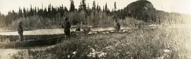
Print preview Close

Showing 4134 results

Archival description
3619 results with digital objects Show results with digital objects
On the Crooked River
2014.10.1.133 · Item · 1910
Part of Arthur Holland Land Surveying Collection

Photograph depicts three boats on the edge of a small river. Two men attend each boat. Wild grasses with a skiff of snow in the foreground, river, forest and a low forested bluff in the background.

Open Field in Giscome
2012.13.1.87.069 · Item · [between 1975 and 1995]
Part of J. Kent Sedgwick fonds

Image depicts a field in Giscome, B.C. On the right side of the image, in the background, is a grey strip that appears to be a mine, possibly the quarry at Eaglet Lake in Giscome, B.C. Map coordinates 54°03'52.9"N 122°22'10.0"W

Open Field in Giscome
2012.13.1.87.068 · Item · [between 1975 and 1995]
Part of J. Kent Sedgwick fonds

Image depicts a field in Giscome, B.C. On the right side of the image, in the background, is a grey strip that appears to be a mine, possibly the quarry at Eaglet Lake in Giscome, B.C. Map coordinates 54°03'52.9"N 122°22'10.0"W

Open Field in Giscome
2012.13.1.87.163 · Item · [between 1975 and 1995]
Part of J. Kent Sedgwick fonds

Image depicts an open field and Giscome, B.C. in the background. Map coordinates 54°03'52.9"N 122°22'10.0"W

Open Pit
2012.13.1.50.093 · Item · [1978?]
Part of J. Kent Sedgwick fonds

Image depicts an open mining pit at an uncertain location; it is possibly Gibraltar.

Orchard Irrigation
2012.13.1.82.27 · Item · 1981
Part of J. Kent Sedgwick fonds

Image depicts water flowing through an irrigation channel in an orchard, somewhere in or near Seton Portage, B.C.

Oscar Peak
2012.13.1.57.24 · Item · 1982
Part of J. Kent Sedgwick fonds

Image depicts the north aspect of Oscar Peak overlooking Lava Lake in the Nass Valley.

Oscar Peak
2012.13.1.57.25 · Item · 1982
Part of J. Kent Sedgwick fonds

Image depicts the north aspect of Oscar Peak overlooking Lava Lake in the Nass Valley.

Other Town Plans
2012.13.1.030 · Subseries · [between 1985 and 1988]
Part of J. Kent Sedgwick fonds

File contains slides depicting old town site plans for various cities.

Otter Creek, BC
2009.5.2.70 · Item · 6 June 1937
Part of Taylor-Baxter Family Photograph Collection

Photograph depicts a shallow creek winding through dirt area, forest in background. Handwritten annotation on verso of photograph: "Otter Creek Showing overlying moraine 6/6/37". See also item 2009.5.2.69.

2009.7.1.277 · Item · [ca. 1880-1920]
Part of Archdeacon W. H. Collison fonds

Wide angle photograph of many buildings scattered in a clear cut area. Foreground shows several businesses, including "Kelly Carruther's Supply" and "Prince Rupert Hardware and Supply Co." Some remaining forest is visible in the background. Annotation on recto reads: "Prince Rupert, BC 1659."