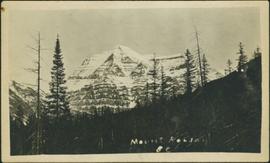
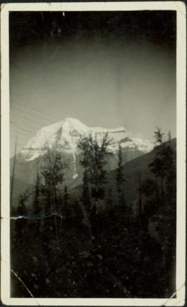
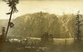
Photo of a mountain with what appears to be Stewart, BC at its foot. Printed annotation on recto is partially obscured by fading and reads: "[Illegible] Stewart, BC."
Image depicts a mountain with a thin line of what appears to be a road visible on the side, with the Bear Glacier located on the left side of the image.
Image depicts what is possibly the Robson River at the base of Mt. Robson.
Image depicts a mountain at an uncertain location.
Photograph depicts mountain in background, trees and hillside in foreground. Handwritten annotation on verso of photograph: "Mount Robson BC."
Photograph depicts mountain in background. Power lines, trees, and hills in foreground. Handwritten annotation on recto of photograph: "1926."
Image depicts the old trading post at Mount Robson Ranch.
Image depicts an old gas pump at the Mount Robson Ranch.
File contains slides depicting the Mount Robson Ranch.
Image depicts the Mount Robson Ranch.
File contains slides depicting numerous individuals hiking up Mount Robson.
Image depicts Mount Robson while en route to Mount Robson Ranch in B.C.
Handwritten caption below this photo reads: "Bought in Picture Prince George". Photograph depicts a mother grizzly bear standing on her hind legs against tree, so that her facial profile is visible. Two cubs stand on hind legs facing and leaning against her.
File consists of a copy of a reprint from the Canadian Journal of Civil Engineering (vol. 6, iss. 1) entitled "Morphological Effects of Interbasin River Diversions".
Image depicts the Bulkley River running through Moricetown Canyon.
Image depicts a church on a hill in Moricetown, B.C.
Image depicts a few old buildings, as well as several unknown individuals somewhere in Moricetown, B.C.
Image depicts an old earth flow in Moran Canyon, somewhere in the Lillooet area.
Image depicts the Fraser River running through the Moran Canyon near Lillooet, B.C.
Image depicts a view of Moran Canyon in the Lillooet area. The Fraser River is visible on the left.
Image depicts the Fraser River running through the Moran Canyon near Lillooet, B.C.
Image depicts a view of Moran Canyon in the Lillooet area.
Image depicts the Fraser River running through the Moran Canyon near Lillooet, B.C.
Image depicts the Moran Canyon near Lillooet, B.C.
Image depicts what is possibly the Fraser River running through the Moran Canyon near Lillooet, B.C.
Image depicts the Moran Canyon; the Fraser River is visible near the bottom.
Photograph depicts Moran seated to right of woman on bench in foreground. Waterfall area at Moricetown Canyon can be seen below, behind booth labeled "MONITER BOOTH". Highway and houses visible on opposite shore in background.
Footage of a moose hunt, moose kill, and butchering of the moose.
Possible locations of this footage are the Chilcotin region, Rainbow Mountains or Tweedsmuir Provincial Park.