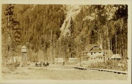
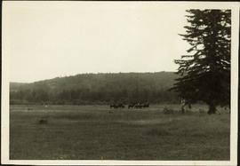
Print preview Close

Showing 4134 results

Archival description
3619 results with digital objects Show results with digital objects
Hospital Beach?
2012.13.1.84.43 · Item · 1994
Part of J. Kent Sedgwick fonds

Image depicts what is possibly Hospital Beach in Kitimat, B.C. The facility in the background is possibly the Alcan smelter.

House - Elevated Main Floor
2012.13.1.87.079 · Item · [between 1975 and 1995]
Part of J. Kent Sedgwick fonds

Image depicts a house with the main floor and entrance high off the ground. The location is uncertain, likely Giscome, B.C.

House 40
2012.13.1.84.46 · Item · 1994
Part of J. Kent Sedgwick fonds

Image depicts a house with a vehicle in a garage and the number 40 on it; location is uncertain.

House in Giscome
2012.13.1.87.159 · Item · [between 1975 and 1995]
Part of J. Kent Sedgwick fonds

Image depicts a house in Giscome, B.C. Map coordinates 54°04'17.6"N 122°22'06.1"W

2012.13.1.87.050 · Item · [between 1975 and 1995]
Part of J. Kent Sedgwick fonds

Image depicts a house being removed from Upper Fraser, B.C. during demolition of town site. A sign on the house reads: "Murray Blackwell House Raising & Moving." Map coordinates 54°06'51.6"N 121°56'26.3"W

House with Ivy
2012.13.1.87.116 · Item · [between 1970 and 1990]
Part of J. Kent Sedgwick fonds

Image depicts a house with ivy growing over it. The location is uncertain.

Houses
2012.13.1.22.12 · Item · 1970
Part of J. Kent Sedgwick fonds

Image depicts numerous houses, and an unknown child standing in a street at Island Cache.

Houses
2012.13.1.22.17 · Item · 1970
Part of J. Kent Sedgwick fonds

Image depicts a few houses and a dog on a porch at Island Cache.

Houses and a Ballpark
2012.13.1.93.01 · Item · 1978
Part of J. Kent Sedgwick fonds

Image depicts a view of numerous houses and a ballpark at an uncertain location. It is possibly located somewhere in the Peace River Region.

Houses and Three Goats
2012.13.1.87.021 · Item · [between 1975 and 1995]
Part of J. Kent Sedgwick fonds

Image depicts several houses, and three goats standing on a narrow dirt road. The location is uncertain, likely Sinclair Mills, B.C.

Houses and Train in Giscome
2012.13.1.87.073 · Item · [between 1975 and 1995]
Part of J. Kent Sedgwick fonds

Image depicts the Giscome B.C. townsite from across the railroad tracks looking southeast. Map coordinates 54°04'19.7"N 122°22'04.7"W

Houses in Giscome
2012.13.1.87.072 · Item · [between 1975 and 1995]
Part of J. Kent Sedgwick fonds

Image depicts the Giscome B.C. townsite from across the railroad tracks looking southeast. Map coordinates 54°04'19.7"N 122°22'04.7"W

2011.3.1.06 · Item · [ca. 1905]
Part of North Coast & Central BC Postcard Collection

View of peninsula with houses and trees. Dock in mid ground, trees and grasses in foreground. Recto stamped “Port Simpson DE 17" and "Port Essington DE 18". Handwritten annotation on recto of photograph: "W. J. O'Neill Esq. Telegraph Point Via Pt. Essington B.C. Don't you think this pretty [Weggs & Mr. Byron?] was over last night - said he saw you and [Halie?]. Yours - BaBa".

Houses on Stilts
2012.13.1.6.106 · Item · Nov. 1980
Part of J. Kent Sedgwick fonds

Image depicts a number of houses built on stilts over a body of water in an uncertain location.

2012.13.2.02.46 · File · 2001-2005
Part of J. Kent Sedgwick fonds

File consists of notes and reproductions relating to the Hudson's Bay Company subdivision. Includes material on the subdivision, survey, and sale of lands in Fort George owned by the Hudson's Bay Company.