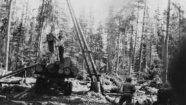
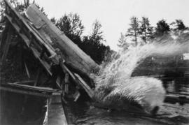
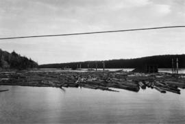
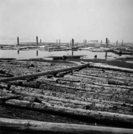
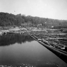
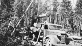
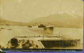
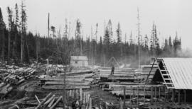
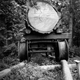
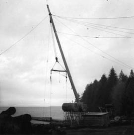
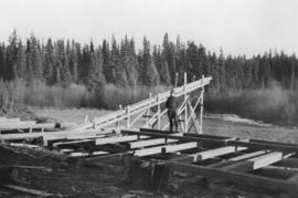
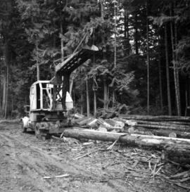
Photograph depicts logging on a side road on the Sechelt Peninsula about 2 miles southeast of Halfmoon Bay.
Photograph depicts a logging museum in Ladysmith on Vancouver Island.
Photograph depicts a logging bridge over Lois River between Saltery Bay and Lang bay, south of Powell River.
Image depicts a logging area somewhere near Prince George, B.C.
Photograph depicts two men using a gin pole, winch and jammer to load raw logs onto a logging truck, likely near Peden Hill sawmill.
Photograph depicts two men felling a tree using a two-man crosscut saw in the Prince George area for processing at Peden Hill sawmill.
Photograph depicts pole climbing in logger sports probably at Squamish, B.C.
Photograph depicts logger sports at Squamish, B.C.
Photograph depicts a man standing on a pile of logs in the Peden Hill sawmill yard, after the mill was rebuilt after the first mill burnt down in 1941. The first mill was operated by steam; the second mill was powered by a diesel-powered motor.
Photograph depicts a log on an old trailer bed.
Photograph depicts a log dump on seashore about 5 miles north of Powell River and opposite Hardwood Island. The view is looking north.
Photograph depicts a man standing near a log deck at a sawmill, possibly at Peden Hill sawmill.
Photograph depicts a man standing next to a log chute bringing logs out of the Fraser River into a backchannel at Peden Hill sawmill.
Photograph depicts a log boom in the Fraser River. These logs were waiting to go into jackladder and down the log chute into the Fraser River backchannel at Peden Hill sawmill.
Photograph depicts a log boom probably in the Lower Mainland or on Vancouver Island.
Series consists of research material relating to steam and diesel locomotives that were used on British Columbia railways. Includes information about the steam to diesel transition period, details about specific locomotives, locomotive manufacturers, and self-propelled coaches.
Plan depicts the location of the Lyon Creek Bridge and borrow pit on the CNR Clearwater subdivision.
Map depicts producing mines and prospects in British Columbia and parts of Alberta.
Map depicts locations of all mining properties in British Columbia. Includes index with names of owners of properties.
Photograph depicts a man in work clothes and hard hat standing with hands placed on the first of many tram buckets hanging in a line. Steel beam framework of station building rises above him. Handwritten annotation on recto of photograph: "[F1?] LOADING STATION EL. 5800". Photograph was glued to cardboard backing with the annotation: "1962".
Photograph depicts three men loading raw logs onto a 'Maple Leaf' Chevrolet truck near the Peden Hill sawmill.
Six men visible on hillside and wood plank roadway, working together to roll cut logs down the hill and load them onto the truck.
Handwritten annotation in pencil on verso read: “logs up to 32 feet in length.”
Film begins with aerial footage of mountains believed to be around Bella Coola. Then recording of men loading barrels, supposedly of gas, into a boat using a "home made" winch and boom construction. They ferry the barrels up stream, the river is assumed to be Dean River. and use a similar construction to bring the barrels to shore.
There is also footage of men fishing in the river.
Photograph depicts loading coal at Buckley Bay. Coal is from Tsable Mine belonging to the Comox Colliery Co. The view is looking north.
Item is a photograph of the Lloyd Bros. Cluculz Lake Operation in April 1964.
Series consists of two ledgers and two journals. The two ledgers consist of logging accounts including lumber shipments and sales as well as payroll and expenditures. The two journals include handwritten maintenance notes and loose papers of diagrams of equipment.
Series consists of 6 ledgers which record expenses for the mine and various other company owned premises in town.
Dock in foreground, ship in water, mountain in background. Unidentified men partially visible in foreground. Printed annotation on recto reads: “Launching of Canadian Scottis –CGM.M. 5500, ton ship at Prince Rupert B.C.”
Image depicts a large saw at an indoor location, likely in a saw mill somewhere in Prince George, B.C.
Large crowd is gathered around main building in a harbor. Many boats visible in foreground. Smoke from tugboat partially obscures the scene. Annotation on recto reads: "Prince Rupert BC. Photo by MCrae Bros."
File contains images depicting various landslides near Cassiar BC. Set of 20 photographs (with 9 corresponding negative strips) date stamped June 1987 depict landslide near creek and dirt road with a Cassiar company truck. Set of 5 black and white photographs found in envelope marked "D. Stewart" are likely from 1988-1989 and depict a rockslide on the south western side of the pit mine, near the tramline. Album entitled “6200 DUMP SLIDE / SPRING, 1979” contains 34 photographs depicting aerial shots of a massive rockslide on the eastern slope of McDame Mountain, originating from the mine waste dump. Several images from album show greenish water pooling in the toe of the slide.
File consists of material relating to provincial lands surveys. Materials include newspaper clippings, a pamphlet, a booklet, a reproduction of the land survey act, and reproductions of articles. Highlights include:
- Province of British Columbia, "Protecting Land Survey Monuments", [198-?] (pamphlet)
- Nominal Roll, "The Land Surveying Profession in British Columbia", 1970 (booklet)
Image depicts what appears to be the old, abandoned mill in Lamming Mills, B.C.
Image depicts what appears to be a part of the old, abandoned mill in Lamming Mills, B.C.
Image depicts the Lakeland Sawmill in Prince George, B.C, identified by the beehive burners; the one with white smoke belonged to Pas Lumber Co. which was bought out by Lakeland in 1987.
Image depicts the Lakeland Sawmill in Prince George, B.C.
Image depicts the Lajoie hydroelectric generating station at the Lajoie Dam on the Bridge River (view of powerhouse and tailrace from top of dam).
This collection is of Kutcho Creek Camp that was set up by a crew led by Cassiar's Chief Geologist Bill Plumb in 1966.
There are six photographs showing the temporary buildings, paths and barrels. These photos were taken from a high hill looking down at the camp. Two photographs depicts the valley of Kutcho Creek area, and the exploration camp is in the distance at foot of hill. One photograph depicts valley of Kutcho Creek area with a body of water in foreground, and mountains in background.
Another photograph depicts man believed to be Matt Bell standing in Kutcho Creek exploration camp. There are tents on either side, a wood structure in background and a sign on wood post: "PLUMB BLVD."
One photograph believed to have been taken near Kutcho Creek, during the initial exploration trip led by Cassiar's Chief Geologist Bill Plumb. Bill stands to left of man believed to be Matt Bell in right foreground. Bulldozer works along talus slope in left foreground.
Another photograph of this initial trip shows a bulldozer working along talus slope in centre of image.
Proposed master plan for the inner areas of Kitimat Port. Drawing includes proposed terminal area, industrial terminal, future forest products terminal, bulk terminal, and the industrial corridor.
Image depicts what is possibly the Alcan smelter in Kitimat, B.C.
File consists of material relating to Kitimat and its recognizable features like trails, mines, and industries like Alcan. Materials include newspaper clippings, pamphlets, booklets, newsletters, and a magazine. Highlights include:
- District of Kitimat, "Kitimat British Columbia Canada", [197-?] (pamphlet)
- Alcan Smelters and Chemicals, "Hike Kitimat: An explorers' guide for the whole family", [197-?] (booklet)
- Alcan Smelters and Chemicals, "Kitimat/ Kemano the first 25 years August 3, 1954-1979", 1979 (booklet)
- "Kitimat through Eurocan's Eyes" , [after 1972] (promotional booklet)
- Royal Canadian Legion, "The Bugle", 1980 (newsletter)
- Kitimat Chamber of Commerce, "Visitors' Guide to Kitimat", [197-?] (pamphlet)
- Alcan Smelters and Chemicals, "Alcan Smelter Tours 1978", 1978 (pamphlet)
- Alcan Smelters and Chemicals, "Alcan in British Columbia", 1977 (booklet)
- Kitimat Chamber of Commerce, "Fishing in Kitimat B.C.", [198-?] (pamphlet)
- Alcan Smelters and Chemicals, "Alcan in British Columbia", 1972 (pamphlet)
- Outwest Magazine, "Kitimat British Columbia", Vol.1 No. 1, 1975 (magazine)
Technical drawing of Kettle Valley Railway depicts trackage and a gradient profile for the line.
Photograph depicts ore haul truck at dump in mine, driver visible, mountain range in background. Handwritten annotation on recto of photograph: "Kenworth - Model 802 dumping stripping waste at 6565 Elevation", on verso: "1961".
Map depicts the city of Kelowna and area. Annotated by Davies to emphasize rail lines.
Map depicts area around Kelowna, with annotated Kettle Valley Railway Carmi subdivision line, Hydraulic Lake, and McCulloch.
Plan depicts the location of buildings occupied by the Northern Construction Company on the old Kamloops Station ground.