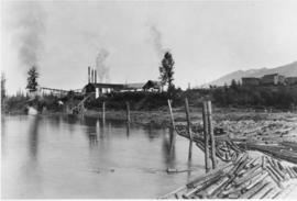
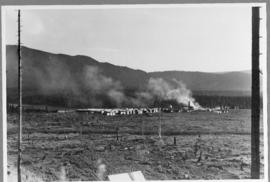
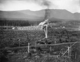
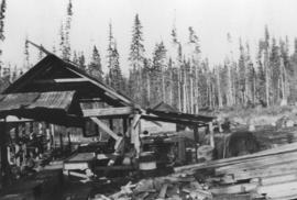
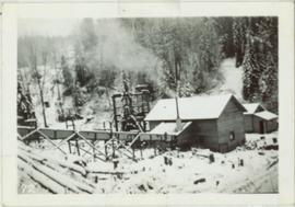
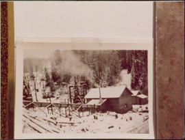
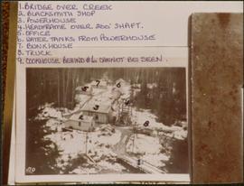
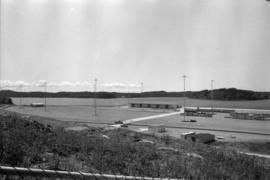
Photograph depicts Red Mountain Lumber Company mill owned by Roy Spurr in Penny, BC in 1929. Scattered all around the mill are the remnants of the previous coniferous forest that was destroyed in the Penny Fire that occurred 2 years earlier.
Reclamation is the process of recovering disturbed land to its former state or other productive uses. This collection of photographs depicts men at work instituting a project on the control of erosion and to restore the mined areas to a condition in keeping with the environmental standards.
Photograph depicts the Peden Hill sawmill, after the mill was rebuilt after the first mill burnt down in 1941. The first mill was operated by steam; the second mill was powered by a diesel-powered motor.
Item is a photograph of Mr. Williston with a group of men at a logging operation, exact location unknown. Mr. Williston is second from the right.
Fonds consists of photographs, scrapbooks of newspaper clippings and memorabilia, correspondence, reports and other textual material. The photographs relate to Mr. Williston’s life from childhood to the late 1990s, the scrapbooks document Mr. Williston’s years in political office, and the textual materials relate to both Mr. Williston’s public life and private interests.
Williston, Ray GillisPhotograph depicts a ramp and boats at the Prince Rupert marina, including the "Northern Dawn".
Hand drawn draft map depicts historical railway routes in British Columbia. Includes dates and annotated information about rail lines.
File contains:
- Signed Christmas greeting card from British Columbia Railway, circa 1973-1983
- Original commemorative presentation folio with railway illustration print and leaflet "The President and Directors of the Northern Pacific Railway Company announce the Fiftieth Anniversary of the Completion of the First Northern Transcontinental Railway System, September 8, 1883 - September 8, 1933"
Map depicts all current rail lines in Western Canada and Alaska and major railway stations. Includes insets for Alaska & Yukon, Edmonton area, Winnipeg area, and the Vancouver area.
Map depicts railway lines in the state of Washington, including those crossing over the border into British Columbia.
Map depicts rail trackage in the Greater Vancouver area, showing dates of completion and abandonment of railway lines. Also shows proposed rail lines.
Photograph of a line of rail cars along a track next to a blasted pile of rubble. Printed annotation on recto reads: "Photo by McRae Bros. Prince Rupert." Handwritten annotation on verso reads: "Hello Charly. I have been dead for 2 month and just woke up tell the folks out home I am doing[??] fine. don't know when I will be down again Remember me to the good little woman, and weave[??] all Well. you're[??] friend Stan C." Postcard is addressed to: "Mr. Charles Chislett 96 Colonist Printing Co. Broad Street Victoria B.C." Verso is affixed with a one cent Canadian stamp. Postmark reads: "Prince Rupert B.C. [illegible date]."
Photograph depicts two wooden buildings in a snow covered forest environment. Photo is adhered to paper backing, upon which handwritten annotation on recto reads: “Quesnelle Quartz mining Company Hixon, B.C. Taken in mid nineteen thirties. Powerhouse from rear. Present day (1973) logging road would run through powerhouse at immediate rear of it at which you are looking. Tom Marsh Box 156 Squamish BC V0N 3G0 December 1978”
Photograph depicts two wooden buildings in a snow covered forest environment. Photo is adhered to paper backing, upon which handwritten annotation on recto reads: “Quesnelle Quartz Mining Co. Hixon BCTaken in mid 1930ies. Power house from rear. Present day (1973) Logging road would run through powerhouse at immediate rear of it at which you are looking. Tom Marsh Box 150 Squamish BC 1978.12”
Annotated overview of the Quesnel Quartz Mine Camp, with buildings numbered and a corresponding legend provided. Annotation on recto of photograph states: "1. BRIDGE OVER CREEK 2. BLACKSMITH SHOP 3. POWEROUSE 4. HEADFRAME OVER 200' SHAFT 5. OFFICE 6. WATER TANKS FROM POWERHOUSE 7. BUNKHOUSE 8. TRUCK 9. COOKHOUSE BEHIND #6 CANNOT BE SEEN" Additional annotation associated with photograph states: "We were always able to find the cookhouse even though hidden in this picture. Taken about 1935 by Russell Ross Supt. Quesnel Quartz Mine"
Image depicts numerous wood piles near the sawmill somewhere in Quesnel, B.C.
Image depicts a sawmill somewhere in Quesnel, B.C.
Image depicts a pulpmill, likely Northwood, in Prince George, B.C.
The Publications series consists of news bulletins and newspapers documenting the community and work life of the residents of Cassiar, BC. Content includes text and photographs, as well as jokes, comics and games.
On March 7, 1956 the Cassiar Reporters Guild published one issue of an untitled newspaper simply titled “The Cassiar?” (vol.1, no.1) along with a “name that newspaper” contest call out to the local community. It is believed that no other issue of this first volume was published until December 7, 1957 when The Asbestos Sheet (vol.2, no.1) was published. The Asbestos Sheet, was generally published twice a month and ran from December 1957 to September 1976; after which time both its name and its format changed: the 8-1/2 x 10” news bulletin changing to an 11 x 17” newspaper; and The Asbestos Sheet becoming the Cassiar Courier. The Courier was published monthly from fall 1976 until February 1991 when it stopped circulation shortly before the closure of both the mine and the company town.
Photograph of community gathering at someone's house. Found in file labelled "public relations."
Plan depicts a section, profile, and contour plan of the fill of the Lyon Creek Trestle bridge in the Clearwater CNR subdivision.
Technical drawing of the proposed boat basin in Kitimat depicts the tailings opening into the port on the upper NE corner of the proposed port.
Technical drawings of the proposed boat basin in Kitimat depicts the tailings opening to be in the middle of the proposed port facing east.
Publication is entitled "Proposal for a New Grain Terminal at Prince Rupert", which outlines a grain shipping terminal at Prince Rupert, its design, a suggested site and estimated costs.
Conveyor sits on tall steel framework, encased in steel sheeting, and stands to right of snow-covered slope. Propane tank sits on log structure below conveyor. Snowy mountains in background. See also item 2000.1.1.2.373. Handwritten caption below this photo reads: "Project completed - at 52˚ temp."
File contains photographs taken for promotional purposes.
- Two photos depict a Cassiar display at an unknown event in 1963.
- Eight photos were professionally taken for use in the 1978 Cassiar Asbestos Corportaion Ltd. Annual Report, and possibly other publications. These photos depict a skyscraper and products made with asbestos.
- Additionally, two hand painted postcards of McDame Mountain and Christmas Tree House are included that may have been used for promotional reasons. Also, four slides of a display, "Story of Asbestos."
- five photographs of unofficial tour of Cassiar via airplane in the 1970s.
Photograph of a small vessel on the ocean with a dock and harbour buildings in the foreground. Tents and piles of lumber can be seen among the buildings. Annotation on recto reads: "The Wharf, Prince Rupert, BC. 1657." Printed annotation on verso reads "The Wharf, Prince Rupert, BC J. Howard A. Chapman, Victoria. BC. 1657."
Photograph depicts a shipping terminal in Prince Rupert. Shipping containers are in the distance.
Photograph depicts a shipping terminal in Prince Rupert. The ocean is visible in the background.
Photograph depicts a shipping terminal in Prince Rupert. The photo is taken from a hill, and several shipping containers sit in the almost empty lot. The ocean is visible in the background.
Photo of entire ship building plant, including several vessels in the foreground. Hills are visible in the background. Annotation on recto reads: "Prince Rupert Ship Repair and Ship Building Plant. Prince Rupert BC. Frank E Kirby, William T Donnelly, Engineers. 17 Battery Place. NYC."
This commemorative souvenir was produced by the Prince Rupert Pioneers’ Association in 1914. Its content provides a textual overview of the individual persons who pioneered the establishment of Prince Rupert, as well as, their associated portrait photographs. This publication also provides a brief introduction to the history of Prince Rupert and includes some related historical photographs.
Photograph of many fishing boats in a harbour. Printed annotation on recto reads: "Prince Rupert Halibut Fleet landing 500,000 LBS. WWW."
Photograph depicts 6 Men on a fishing boat with water in the background. Equipment on the boat is covered with a very thick layer of ice. Printed annotation on recto reads: “Rupert Fishing Boat After Stormy Trip Jan 1916”. Handwritten annotation in pencil on verso reads: “Rupert Fishing Boat , A Stormy Trip”.
Publication is entitled "Prince Rupert Bulk Loading Facility: Phase 2 Environmental Assessment of Alternatives" by the Northcoast Environmental Analysis Team.
Image depicts the Prince George Sawmill from the Northwood Bridge.
Image depicts Prince George Sawmill taken from across the Nechako River looking southwest. Map coordinates 53°56'00.0"N 122°44'29.7"W
The Prince George Railway & Forestry Museum Society Collection consists primarily of textual, photographic, and cartographic records related to the regional developments of the railway industry in Northern BC. A predominant portion of the collection is made up of material from the Canadian National Railway; other railways represented include the Pacific Great Eastern Railway, the British Columbia Railway (BC Rail), the Grand Trunk Pacific Railway, the Grand Trunk Railway, the Intercolonial Railway, and the Okanagan Express. Significant geographical areas covered include Prince George, the Peace River Region, Terrace, Bulkley Valley, Hazelton and Prince Rupert.
The forestry industry is represented in the collection with operational and financial records from Fyfe Lake Sawmill Ltd., which operated southwest of Prince George in the 1950s.
The collection has been organized into series according to creator, each of which also has been arranged to subseries, file and item level, where applicable. This collection consists of eight series, as follows:
1) Canadian National Railway
2) Grand Trunk Railway
3) Pacific Great Eastern Railway
4) British Columbia Railway (BC Rail)
5) Canadian Pacific Railway (CPR)
6) Intercolonial Railway
7) Fyfe Lake Sawmill ltd.
8) PGRFM
9) Photographs
This fold out brochure, published by the Prince George Board of Trade, provides an overview of the industries present in Prince George by the BC Centennial; as well as a brief presentation of local recreational opportunities and a mileage listing.
Image depicts a sawmill in Prince George, B.C.
Image depicts Prince George from University Way, with the P.G.I pulp mill in the distance.
Image depicts Prince George from University Way, with the P.G.I. Pulp Mill in the distance.