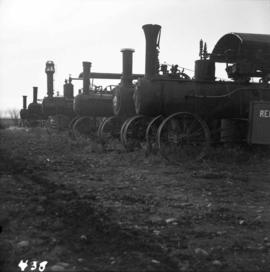
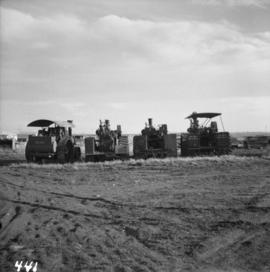
Photograph depicts a rear view of 4 of the 6 traction engines in Nanton, Alberta. The left engine was built by Reeves and Co. in Columbus, Indiana, U.S. Its identification is #4438, it has 2 cylinder simple, and a roof. The next engine was built by Waterloo Mfg. Co. Ltd. in Waterloo, Ontario and has a single cylinder. The third engine was built by Sawyer Massey. The engine on the right side is a Gaar Scott, built in 1913, and has 25 horsepower on the drawbar and 75 horsepower on the belt.
Photograph depicts traction engines owned by Jack Burrows in Nanton, Alberta. There are six in this photo, all of which appear could be steamed, another two in derelict condition, and one in the village in working order. Running from front to rear in the photo: 1) Reeves with roof, U.S. 2) Waterloo, Ontario, Canada 3) Massey, Canada 4) Gaar Scott with roof, U.S. 5) Massey, Hamilton, Canada 6) Gaar Scott, U.S.
Photograph depicts a traction engine built by Sawyer Massey in Hamilton, Ontario. It has a single cylinder and large fire box for burning wood or straw. The engine is located in Nanton, Alberta.
Photograph depicts a traction engine at a ranch on Nicola Lake, near Merritt. The engine was made by Nichols-Shepard Co. at Battle Creek, Michigan and named the "Red River Special." It is undated and has 2 cylinders, side tanks, 16-10 horse power, wood burner, firebox 5 ft. long.
Photograph depicts lettering on several ballast cars which were headed by a tracktor and tailed by a caboose.
File consists of research material regarding trackside operations, which predominantly consist of photocopy reproductions, excerpts from books, and clippings from periodicals (mainly model railroading magazines). Includes information on track fitments, rail bumpers, train order boxes, hose houses, swinging gate crossings, stock guards, telephone boxes, rail and flange lubricators, snow fences, and section houses. Also includes "Recollections of an E&N Railway Trackman, 1945-1955" by Bill Batchelor (recorded by Davies) and "Wyes in Southwestern B.C. and Vancouver Island" by Mike Green.
Photograph depicts tracks made by machinery in an earth road turning left in forest.
Unidentified animal tracks in mud?
Animal tracks in snow
Photograph depicts a "trackmobile" in the CNR Boston Bar yard. Work on replacing ties was being carried out 5-10 miles to north.
Photograph taken near Manning Park.
Photograph depicts spike pulling machines proceeding south. Part of the first operation of dismantling the KVR line.
Photograph depicts the trackage in the mid section of the McCulloch depot area. The left line is a passing track, the mid line is the mainline, and the right track is for storage. The depot is located at mile 76.6, on the Carmi Subdivision. The view is looking north.
Photograph depicts trackage near the CPR depot in Salmon Arm.
File consists of documents regarding track vehicle specifications, which predominantly consist of photocopy reproductions, excerpts from books, and clippings from periodicals. Includes information on push cars, speeders, inspection cars, section cars, motor cars, and other maintenance of way vehicles.
Photograph depicts the track transfer transporter at the Canadian National Railway (CN) repair shops at Port Mann.
Photograph depicts the track transfer transporter at the Canadian National Railway (CN) repair shops at Port Mann, showing the east face of the main building.
Photograph depicts a track shed about 1 mile south of Beaverdell or at about mile 43.25 on the CPR line in the Carmi Subdivision. Despite the open doors and ease of access, it was the only hut on the line found to contain track materials and correspondence. It retained 50 memos addressed to the Section Foreman [at Beaverdell?].
File consists of research material regarding maintenance of way track sections before 1960, which predominantly consist of photocopy reproductions, excerpts from books, and clippings from periodicals. Includes information on pump cars, maintenance of way employees, section gang administration, track trollies, track tools, speeder patrols, tool sheds, section houses, and plans for maintenance of way structures. Also includes the following pieces by Davies: "Track Maintenance Facilities on CNR line: Jasper to Prince Rupert, 1915-1960s"; "History of Track Sections/Houses of CPR/KVR/GNR Princeton Sub."; and "Railway Sub-Divisions in B.C. and Probable Number of Sections Within Them".
File contents relate to: Mine Maintenance Issues. Document type(s) include: report. Notes: budget for projects.
Track laying machine situated on a large mound of earth which is surrounded by (flood?) water.
Ten men working with a large mechanical track layer to lay down the ties for the PGE line.
Photograph depicts a CN Track Geometry 'Test" car for Western Canada. Built in 1954 as "Cape Race." In 1983 it was a VIA sleeper/buffet/lounge.
Photograph depicts a track car model (in fact, the base to the lamp shade).
Photograph taken about 2 miles west of Princeton. Depicts track beside the Tulameen River. Taken, looking west, form a ridge holding on the Princeton to Hope highway.
Series consists of material regarding the laying and maintenance of railway track and other trackside operations in British Columbia. Includes information about rails, track, turnouts, rail ties, gradients, telegraph lines, track signage, road crossings, and diamond crossings.
File contains a transcript of an interview with ‘Wilkins’.
File consists of an issue of Trace Magazine, a Canadian architecture magazine.
File consists of issues of the literary periodical entitled "Trace".
Three little boys playing with boats on the water, Nunavut
File consists of notes and reproductions relating to townsites along the Grand Trunk Pacific Railway. Includes material regarding townsite planning for McBride, Willow River, Prince George, Terrace, Prince Rupert, and South Hazelton.
Photograph depicts the Cassiar valley. Handwritten annotation on verso of photograph: "1958 [1961 crossed through]", on recto: "Cassiar Asbestos Corporation Limited. Cassiar B.C. Townsite in foreground mill and ore storage in left middle ground," "Toronto set". It is believed that this photograph was made into a post card.
File contents relate to: Town Administration of Cassiar Townsite. Document type(s) include: meter records.
File consists of a typescript document titled "Townsite Promotion at Fort George: G.J. Hammond and the Natural Resources Security Company, 1909-1914" by Neil Holmes.
File consists of photocopied articles relating to townsite planning and development in the plains and along the railway. The articles have handwritten annotations by Kent Sedgwick. File includes: "International perspectives on ralway townsite development in Western Canada 1877-1914" by John Gilpin; "Towns of the Western Railroads" by John C. Hudson; and a photocopied book "Plains Country Towns" by John C. Hudson.
The item is a reproduction of a survey map drafted in 1909. The reproduction was likely created in 1990. The area covered is South of Fort George Avenue, East of Fraser Street, North of Mount Stephen Avenue, and West of Simpson Street. Annotations state, "Pl. 649."
The item is a reproduction of a survey map drafted in September 1909. The reproduction was likely created in 1990. The annotations highlight owners of different lots up to approximately 1959. Th area covered is North of Fifteenth Avenue, East of Irwin Street, South of Eighth Avenue and West of Carney Street. Annotations on attached papers indicate different means of scale and measurement for the map.
File contents relate to: Accounting / Payroll, Town Administration of Cassiar Townsite. Document type(s) include: reports.
Photograph depicts the Cassiar plantsite in foreground, including the mill, dry rock storage building, tailings pile, and many other buildings. Townsite in midground, mountains in background. Handwritten annotation on recto of photograph: "Cassiar."
Photograph depicts the Cassiar plantsite including the mill, dry rock storage building, tailings pile, and many other buildings. A portion of the townsite can be seen on left.
Photograph depicts the Cassiar townsite in foreground. Mill, dry rock storage building, and tailings pile can be seen in background. Handwritten annotation on verso of photograph: "1958 [1961 crossed through]."
Photograph depicts the town of Cassiar in foreground, mountain base in background. Photograph was taken from the air, portion of plane visible in top left of image.
Photograph depicts the town of Cassiar, mountain base in background.