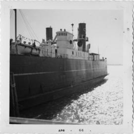
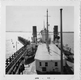
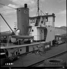
Print preview Close

Showing 21795 results

Archival description
2013.6.36.1.013.30 · Item · Apr. 1966
Part of David Davies Railway Collection

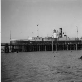
Photograph depicts a C.N.R. rail car ferry, the S.S. Canora, docked at Tilbury, Fraser River, Delta. Note the sailor in bosun's chair on the foremast cleaning the paintwork. This was about 2 weeks before the announcement that the ship would be taken out of service by C.N. at the end of May 1966.

CNR terminal yard, Victoria
2013.6.36.1.059.17 · Item · [23 May 1971]
Part of David Davies Railway Collection

Photograph depicts a Hillcrest Lumber Co. steam crane that was acquired by Terry Fergusan and was moved from Mesachie Lake, Cowichan. It was put to use on the tourist attraction railway, the "Victoria-Pacific," that was created in 1971.

CNR Tete Jaune Subdivision
2013.6.36.1.039.08 · Item · [2 July 1980]
Part of David Davies Railway Collection

Photograph taken on about mile 8 or 10 on the Tete Jaune Subdivision, on the line to Prince George. Located on the north side was the CNR line to Kamloops on the upgrade that passed through a snow tunnel.

CNR Thompson Valley
2013.6.36.1.038.23 · Item · 1 Sept. 1980
Part of David Davies Railway Collection

Photograph taken at about 8 1/2 miles south of Barriere. Davies notes that this was a rare image because there was a single gondola standing on the main track during an average day when it was normally attached to a work train. Men were seen working nearby.

2013.6.36.1.009.49 · Item · Mar. 1966
Part of David Davies Railway Collection

Photograph depicts Canadian National Railway (CN) track crew sheds on Lulu Island at the south end of the Fraser St. road-vehicle bridge, near the intersection of #5 Rd. and Vulcan Way. The track is well used. The view is looking west.

C.N.R. track on Lulu Island
2013.6.36.1.009.20 · Item · Apr. 1966
Part of David Davies Railway Collection

Photograph depicts the Canadian National Railway (CN) track on Lulu Island leading to the swing bridge that crosses the north arm of the Fraser River. The view is looking northeast.

C.N.R. track on Lulu Island
2013.6.36.1.009.21 · Item · Apr. 1966
Part of David Davies Railway Collection

Photograph depicts the Canadian National Railway (CN) track at the east end of Lulu Island. It originally led to a peat plant but now continues southwards to the Lafarge Cement Plant on the south bank of the island. The view is looking due north and there is a whistle board at the left for the Westminster Highway behind the camera.

C.N.R. track on Lulu Island
2013.6.36.1.009.23 · Item · Apr. 1966
Part of David Davies Railway Collection

Photograph depicts the Canadian National Railway (CN) track on Lulu Island, about 4 miles west of the eastern tip of the island. The track to the right runs along the northern edge of the island and the left-hand track goes to the Lafarge Cement Plant on the south bank of Lulu Island.

CNR tractor
2013.6.36.1.114.01 · Item · [May 2004]
Part of David Davies Railway Collection

Photograph depicts a CNR tractor, an old piece of Maintenance of Way equipment coverted to haul equipment required to run at low speeds. It also saved switchers.

2013.6.36.1.009.19 · Item · Apr. 1966
Part of David Davies Railway Collection

Photograph depicts the Canadian National Railway (CN) trestle leading to the swing bridge across the north arm of the Fraser River. The view is taken from Lulu Island, looking northeast. Stumps under the trestle indicate this is the second trestle on the site.

CNR Valemount
2013.6.36.1.038.17 · Item · [30 June 1980]
Part of David Davies Railway Collection

Photograph depicts the depot in Valmount which was still inhabited by an agent. Image captured on mile 74.5 in the Albreda Subdivision

CNR Valemount
2013.6.36.1.038.16 · Item · [30 June 1980]
Part of David Davies Railway Collection

Photograph depicts the depot in Valemount, built according to the type "c," CNR design in 1915. Originally found in Swift Creek, but moved to the present location in 1927. At this date, the depot was actually inhabited by an agent which Davies notes to be a rarity for the period.

CNR Vancouver
2013.6.36.1.035.04 · Item · [15 Oct. 1974]
Part of David Davies Railway Collection

Photograph depicts a CN boxcar that was 56 years old, having been built in 1918. It had a steel frame, but was also built with wood sides and ends. Located in Dunley Street in the CN yards on the site of the old Hastings Mill.

CNR Vancouver Island
2013.6.36.1.044.27 · Item · [29 June 1983]
Part of David Davies Railway Collection

Photograph taken at the CNR Vancouver Island line. Rails and ties were being lifted prior to the date the photograph was taken. Image displays the location of the station's west end siding switch.

CNR Vancouver Island
2013.6.36.1.044.28 · Item · [29 June 1983]
Part of David Davies Railway Collection

Photograph depicts the CNR Vancouver Island line being dismantled. Image captured a section that was left intact and was now owned by a preservation group. Rails labelled "Illinois 1918."

CNR Vancouver Island
2013.6.36.1.044.21 · Item · [June 1983]
Part of David Davies Railway Collection

Photograph taken in the Sooke Lake vicinity. Image captures the road from Shawnigan Lake to Leechtown which is intersected by former trackage. The track may have been removed in 1982.

CNR Vancouver Island
2013.6.36.1.044.22 · Item · [June 1983]
Part of David Davies Railway Collection

Photograph taken in the vicinity of Sooke Lake. Image displays the road from Shawnigan Lake to Leechtown that was intersected by former trackage. A trench was dug to stop access into the Victoria water supply watershed. Rails may have been lifted in 1982.

CNR Vancouver Island
2013.6.36.1.044.24 · Item · [June 1983]
Part of David Davies Railway Collection

Photograph taken in Milnes Landing, depicting former CNR track that became property of a preservation society whose members run speeders over it.

CNR Vancouver Island
2013.6.36.1.044.17 · Item · [23 May 1971]
Part of David Davies Railway Collection

Photo at the corner of Sooke Lake, located 18 miles north-west of downtown Victoria. Davies notes that the lack of rail rust and low growth of vegetation suggest regular, but not too frequent traffic on the line.

CNR Vancouver Island
2013.6.36.1.044.19 · Item · [23 May 1971]
Part of David Davies Railway Collection

Photograph depicts the CNR Vancouver Island Branch in Leechtown. Davies notes that there was now only a passing siding here, but at one time there was a logging operation that included approximately 4 spurs. The surface of the rails suggests regular, but infrequent use.

CNR Vancouver Island
2013.6.36.1.044.23 · Item · [June 1983]
Part of David Davies Railway Collection

Photograph taken in the vicinity of Sooke Lake, north of Leechtown. Location is also within the Victoria watershed area. According to Davies, rails were possibly lifted in 1982, but the trestle still seemed servicable.

CNR Victoria
2013.6.36.1.044.08 · Item · Aug. 1971
Part of David Davies Railway Collection

Photograph depicts the former line from the CNR yards in downtown Victoria. Taken from Boleskine Road overbridge, looking north.

CNR Victoria
2013.6.36.1.044.14 · Item · [July 1982]
Part of David Davies Railway Collection

Photograph depicts a track located beyond a road covered in dense bushes. The rail in the foreground is dated 1918 and 1912. Image captured on Jacklin road, estimated to be on mile 9.2 in the former Cowichan Subdivision.

CNR Victoria
2013.6.36.1.044.03 · Item · [14 July 1968]
Part of David Davies Railway Collection

Photograph depicts the CNR main line from Victoria to Duncan. Image captured looking south from Gorge Road towards a Selkirk water trestle. The line behind the camera was in regular use to the Cedar Hill Grass Roads spur. The main line beside the Island highway ran west out of Victoria.