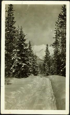
Image depicts a road covered in snow running through the woods at an uncertain location.
Image depicts a snowy road at an uncertain location.
Image depicts a snow-covered road with vehicle tracks, and several houses. The location is uncertain.
Mountains visible in background.
Image depicts the ferry at Soda Creek, B.C.
Image depicts what appears to be a Ranch at Soda Creek, B.C.
Photograph depicts the Soda Creek reaction ferry.
Photograph depicts the Soda Creek reaction ferry. A ferry was sited between Soda Creek and Marguerite. The reaction ferry in Soda Creek itself had been abandoned for some time.
Photograph of a vessel filled with lumber just off the coast of a shore also littered with lumber. Mountains are barely visible in the background.
Handwritten caption above this photo reads: "Sophie [Haach?] [lived?] in the Adams House". Photograph depicts Sophie seated behind table, curtains in background.
Lofty view of stern wheeler in river. Scattered buildings and tents in background. Printed annotation on recto reads: “South Fort George Oct 30th 1910”
Photograph depicts the south shore line of the B.C. Electric Railway in False Creek, Vancouver. B.C. Hydro operated it, if not owned it. The location was directly opposite from Granville Island.
Photograph depicts the South Slocan Junction at mile 11.9 on the CPR line on the Nelson Boundary Subdivision. It closed as an agency in June 1969 but the telegrapher still maintained it. Three to four freights pass per day on the main line: 2 to Trail, 1 to Castlegar pulp mill, and 1 every other day to Midway. On the branch there is 1 train per week to Nakusp that leaves Nelson on Monday, arrives in Nakusp on Tuesday, and returns to Nelson on Wednesday. The view is looking east.
Image depicts the interior of the ferry at Southbank, B.C.
Photograph depicts special equipment opposite a car barn of the B.C. Electric Railway, at New Westminster.
Photograph depicts a Pacific Great Eastern Railway "Special Train" that is "carrying a number of members of B.C. Legislature on their tour of inspection. First train into Lillooet, B.C. Feb. 20, 1915, 5 p.m." The train is depicted on the grade along the Seton River as it leaves Seton Lake.
Photograph depicts a speeder labelled "Rio Grande."
Photograph depicts a CN speeder.
Photograph depicts a speeder labelled "Union Pacific."
Photograph depicts a speeder at a B.C. speeder meet.
Photograph depicts a speeder car.
Photograph depicts a CN speeder.
Photograph depicts a lunch stop at Oyama for the speeder meet. These speeders were Fairmont MT 19.
Photograph depicts a speeder meet of "Motor Car Operators West" enthusiasts. Comprised of 25 cars. All taking part in a weekend tour of the Okanagan. On this day, they were going from Vernon to Lumby and Kelowna. Cars were getting ready to depart at the yard of the Kelowna Pacific Railway in Vernon. The cars were headed south to be preceeded by hi-rail of the KPR.
Photograph taken on the outskirts of Kelowna, in an industrial area about 2 miles north of a branch terminal. The turn around point for all 25 speeders was done on a black-topped, little used public grade crossing.
Photograph depicts a speeder meet along the Okanagan line. As trips started and finished in places that had no washrooms, this mobile porto-potty came along and met definite needs.
Photograph taken at a speeder meet. Davies had ridden in this deluxe vehicle for the whole way along the Okanagan line. Margaret Hope, an organizer of the B.C. segment of a three week tour, mentioned that her husband designed and built the machine.
Photograph depicts a speeder meet. People were taking a rest break at the north end of Monte Lake.
Photograph depicts a speeder meet while on a B.C. run from Armstrong to Campbell Creek Junction and back again. About 25 cars were at the south end of Monte Lake.
Photograph depicts a speeder meet at the Campbell Creek Junction. Visible is a large home-built version.
Photograph depicts a speeder meet while on a B.C. run from Armstrong to Campbell Creek Junction and back again.
Photograph depicts a speeder meet of about 25 vehicles. They were leaving the overpass at Campbell Creek Junction for return back to Armstrong.
Photograph depicts a speeder meet at the Campbell Creek Junction. All speeders, consisting of 25, had just turned around and were ready to go south to Armstrong.
Photograph depicts a speeder at the edge of the East Fork Canyon Bridge over Klo Creek. This is located at mile 86.5 on the CPR Kettle Valley Railway in Myra Canyon. The view is looking north.
Photograph depicts Spences Bridge on the Thompson River and the only surviving pier of the earlier Spences' Bridge. View looking at east bank.
Photograph depicts a Sperry Rail service car #136 at the Penticton C.P.R. depot. It is for detecting faulty or broken rails and visits the area once a year. It is moving off to start work at mile 34 west of Penticton.
Photograph depicts a Sperry Rail service car #136 at the Penticton C.P.R. depot. Note the larger bogie on the right hand bogie which accommodates detection gear. It is being serviced before moving to an area west of Penticton.
Photograph depicts the Sperry Rail service car at the C.P.R. Penticton depot, just moving off to the west.
Photograph depicts the Sperry Rail service car #136 for detection of faulty rails at the Penticton C.P.R. depot. It is used mainly to cover rail manufactured prior to 1932.
Photograph depicts a Sperry Rail Service inspection car that had broken down in the CPR Kamloops yard. Car #127 was built in 1927 as a gas electric car for Boston and Maine R.R. It was modernized in 1989.
Photograph depicts a Sperry Rail testing car in the CPR yard in downtown Kamloops. These cars must have been between 60 and 70 years old, but they were kept in excellent condition. Car #127 was built in 1926 and modernized in 1989.
Item is a photograph of the concrete spillway.
Image depicts a fishing boat on the water somewhere near Prince Rupert, B.C. Only half of its name is visible: "spirit."
Photograph depicts the laying of an extra spur for passenger car storage of Rocky Mountaineer Rail Tours at the CN Downtown Depot in Kamloops.
Photograph depicts a spur leading off the Canadian National Railway (CN) spur to the Lafarge Cement Plant on the south bank and east side of Lulu Island. This spur used to be the original line and led to a peat plant, just seen at left on the horizon. The second car is pushed onto unused and overgrown track, which is dated 1909 Algoma Steel. This siding much used.
The building of this spur in 1977 was a late and short lived attempt to move yearling cattle to Ontario for fattening by rail. The Last stock train ran in 1985. The CN rail track was still in use in August 1998. This photograph shows the spur running east and down grade to a stockyard owned by BC Interior Cattlemen's Association. Additional information is available in article, "Moving Livestock by Rail: An inquiry into an extinct traffic" in The Sandhouse journal, Issue 121, Spring 2006.
Photograph depicts a spur located next to Pounder Emulsions Ltd. Electric capstan (Jeffrey Electric Co, Montreal) used to move full and empty tank cars of bitumen (for blacktops). Did not appear to be used.
Photograph depicts Wilkinson Steel Ltd. The spur was serviced by CN. Visible is an empty bulkhead car that had recently been brought in for its steel.