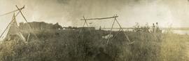
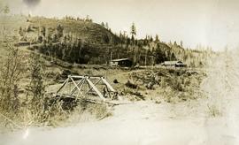
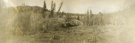
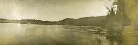
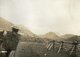
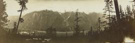
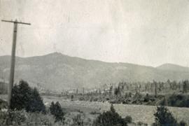
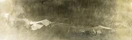
Photograph depicts a view from above the Blackwater telegraph cabin and house. The house has a large fence garden beside, telegraph poles with wires are visible alongside the dirt road. Wood smoke drifts from the house chimney to the sparsely forested area beside.
Photograph depicts a canvas tent and wooden tent frame in the foreground, more canvas tents erected in the background. Two men carry poles on the right, while another man in center photo stands near another pole frame. There is a body of water in the background.
Photograph depicts three men standing on a bridge in the foreground, a cabin and fenced house in the midground, sparsely forested hills in the background. There are telegraph poles with wires between the bridge, cabin and house.
Photograph depicts a body of water surrounded by sparsely forested hills and low mountains.
Photograph depicts the Blackwater bridge and cabin. The forest in the foreground has been roughly cleared.
Photograph depicts a large body of water the shore edged with forest and low hills.
Image depicts an abandoned cabin and shed on Blackwater Road.
Image depicts Blackwater River, B.C.
Image depicts the Blackwater River.
Image depicts Blackwater River.
Image depicts Blackwater River, B.C.
Image depicts a view of Blackwater in the country near Punchaw, B.C.
Image depicts a view of Blackburn Schools, possibly taken from Tabor Mountain.
Item is a hand drawn and coloured map by the City of Prince George Planning Department depicting the Blackburn neighbourhood development area's proposed sector plan in 1976.
Photograph of a large glacier. Printed annotation on recto reads: "Bitter Creek Glacier."
Wide angle perspective of the Bitter Creek glacier, with trees visible in the foreground. Printed annotation on recto reads: "Hughes #22 Bitter Creek Glacier."
Typed message on front reads: “Happy Birthday Your Honour, You have a way of making each person you come in contact with feel so special, so we all want to wish you the happiest birthday year ever. Staff of Government House, October 18, 2002.” Signed by the staff of Government House.
Handwritten annotation on verso reads: “The Rock - I spent 6 years creating 6 gardens surrounding”.
Aerial view of Prince George and surrounding forested area. Printed annotation on recto reads: "Prince George, B.C."
Photograph depicts a panoramic view of Stewart B.C. Annotation on front "Bird's Eye View" "Stewart, BC"
Photograph depicts a view from the railroad looking toward the river and mountain beyond at Billings siding.
Photograph depicts William (Bill) Storie at location known as Limestone Mountain, southwest of Cassiar, B.C. Photo features profile of Bill, hands in pocket, Cassiar valley and mountains in background. Storie was a renowned prospector in the Cassiar area, and the new school at Cassiar was named for him in 1992.
Photograph depicts three men guiding canoe through water. Bushes and forest slash in foreground, bushes on swampy shore in background. Handwritten annotation on recto of photograph: "Bill Barnett at stern of canoe."
Photograph depicts Bill and canoe on sandy shore, river and opposite shore in background. Handwritten annotation on recto of photograph: "Billy Barnett at Giscome Portage."
Photograph depicts the "Big Slide" at Lillooet. Also visible are a horse-drawn cart and the Fraser River.
Photograph of a large explosion on what appears to be a shoreline. Printed annotation on recto reads: "'Big Blast' Prince Rupert. B.C."
Image depicts the a flock of ducks on Big Bar Lake north of Clinton, B.C..
Image depicts two individuals on a canoe on Big Bar Lake north of Clinton, B.C..
Photograph depicts three men standing in a canoe with long poles. Canoe is floating in quiet river water, bluffs in the background.
Photograph depicts a view possibly from a stage coach, fences and rolling hills with dry vegetation in the background.
Rev. William Edwin Collison stands in centre of boat, with wife Bertha and daughters Muriel and Katherine seated behind. Unknown man and woman are also seated in boat, and an unknown man stands on shore holding rope.
Handwritten annotation on verso reads: "Will Collison with wife & children leaving Metlakatla to catch steamship en route to England (1910)".
Image depicts the Berg Glacier at Berg Lake in the Mt. Robson Provincial Park.
Image depicts the Berg Glacier and Berg Lake near Mt. Robson.
Image depicts Bellos Road, most likely in Red Rock, B.C.
Foreground shows two rocky shores covered in dirt and wood debris, connected by a barely visible bridge. Annotation on recto reads: "Before the Blast Apr. 24th 13"
Image depicts a Beehive Burner along the Nechako on River Road. Map coordinates 53°55'34.1"N 122°44'58.0"W
Image depicts a beehive burner, as well as rail road tracks, at an unknown location.
Image depicts an esker at Bednesti Lake, B.C.
Image depicts what appears to be a small ranch. The slide is labelled "Becher's Prairie," possibly meaning Becher's Prairie Provincial Park in B.C.
Image depicts a field of hay somewhere in Beaver Valley.