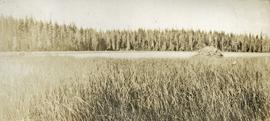
Print preview Close

Showing 3619 results

Archival description
Dog Creek
2012.13.1.52.57 · Item · [1980?]
Part of J. Kent Sedgwick fonds

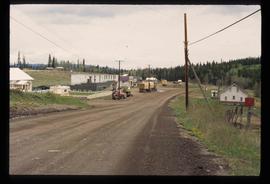
Image depicts a house and numerous rundown vehicles in Dog Creek, B.C.

Dock
2012.13.1.60.18 · Item · July 1973
Part of J. Kent Sedgwick fonds

Image depicts a dock on a lake in Carp Lake Provincial Park, possibly War Lake.

2000.13.1.63 · Item · [between 1962 and 1967].
Part of Ray Williston fonds

Item is a photograph of the diversion tunnel as engineers plan to blast the plug to allow the Peace River to be diverted for construction of the W.A.C. Bennett Dam.

Disturbed Ground
2012.13.1.50.117 · Item · 1980
Part of J. Kent Sedgwick fonds

Image depicts an area of disturbed ground, most likely due to a landslide, at an unknown location.

Disturbed Ground
2012.13.1.50.119 · Item · 1980
Part of J. Kent Sedgwick fonds

Image depicts an area of disturbed ground, most likely due to a landslide, at an unknown location.

2009.5.3.50 · Item · [ca. 1910]
Part of Taylor-Baxter Family Photograph Collection

Photograph depicts settlement across frozen lake. Trees cross midground, mountains stand in background. Handwritten annotation on verso of photograph reads: "Distant view of Tete Jaune B.C.", on recto of photograph: "I marked about where you loaded your boat the telephone pole is down the road toward 53. Tete Jaune Mile 52."

Dirt Road
2012.13.1.87.024 · Item · [between 1975 and 1995]
Part of J. Kent Sedgwick fonds

Image depicts a dirt road leading through numerous trees toward a mountain. The location is uncertain, likely on the way to Longworth, B.C.

Dirt Road
2012.13.1.87.025 · Item · [between 1975 and 1995]
Part of J. Kent Sedgwick fonds

Image depicts a dirt road leading through numerous trees toward a mountain. The location is uncertain, likely on the way to Longworth, B.C.

2000.1.1.4.3.04 · Item · 1961
Part of Cassiar Asbestos Corporation Ltd. fonds

Photograph depicts group of eight men standing in line in the Cassiar valley. Left to right: Charles Rainforth Elliot, John Drybrough, John E. Kennedy, Fred Martin Connell, W. Harold Connell, Ken A. Creery, George Washington Smith, Tam Zimmermann. Power lines and mountains in background.

2000.1.1.4.3.05 · Item · 1961
Part of Cassiar Asbestos Corporation Ltd. fonds

Photograph depicts group of eleven men standing in line in the Cassiar valley. Left to right: Jack Christian, Charles Rainforth Elliot, John Drybrough, John E. Kennedy, Fred Martin Connell, W. Harold Connell, Ken A. Creery, George Washington Smith, Tam Zimmermann, [Fred Murray]?, Nick Gritzuk. Power lines and mountains in background. Most men featured in photo are believed to be members of Cassiar's Board of Directors. Photograph was originally framed with note "Summer 1961" written on cardboard backing.

2012.13.1.87.065 · Item · [between 1975 and 1995]
Part of J. Kent Sedgwick fonds

Image depicts an old house for sale surrounded by overgrown bushes in Upper Fraser, B.C. Map coordinates 54°07'15.0"N 121°57'02.0"W

Dawson Creek
2012.13.1.91.01 · Item · Sep. 1974
Part of J. Kent Sedgwick fonds

Image depicts a road with a guardrail and open fields somewhere near Dawson Creek, B.C.

Dark Image
2012.13.1.60.12 · Item · July 1973
Part of J. Kent Sedgwick fonds

Image depicts light from an unidentified light-source shining on a long, vertical object of an uncertain nature, though it is possibly a tree. The rest of the image is too dark to make out.