Print preview Close

Showing 2849 results

Archival description
2023.2.2.13.1 · File · 2007-2008
Part of Dr. Paul Sanborn fonds

File contains the following data sets:

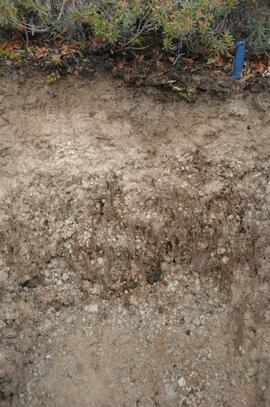
  • S925finl.xls [chemical analysis data, Ministry of Forests & Range, Analytical Chemistry Laboratory for pedons Y07-06 & Y07-07; also includes data for BC07-03 & BC07-04 (Boreal Cordillera grassland soils – see associated file note)]
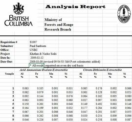
  • S1007finl_revised2.xls [chemical analysis data, Ministry of Forests & Range, Analytical Chemistry Laboratory for pedons Y07-06 & Y07-07: oxalate & dithionite extractions, P retention; also includes P retention data for Nazko pedons BC07-07 & BC07-09]
  • CANTEST lab report 90206003.pdf [particle size analyses for Klutan Glacier pedons Y07-06 & Y07-07; also Tuya pedons BC07-03 & BC07-04 &]
Klutlan Glacier soils
2023.2.2.13 · Subseries · 2007-2010
Part of Dr. Paul Sanborn fonds

With the assistance of the Yukon Geological Survey, Dr. Paul Sanborn was able to visit the terminus of the Klutlan Glacier, a major outlet glacier which originates in the Alaska portion of the St. Elias Mountains. The stagnant terminus has a thick cover of debris, including a large component of White River tephra, providing enough soil material to support a boreal forest. Field work occurred on July 8, 2007, and results were published as:

Sanborn, P. 2010. Soil formation on supraglacial tephra deposits, Klutlan Glacier, Yukon Territory. Canadian Journal of Soil Science 90: 611-618. https://doi.org/10.4141/cjss10042

2023.2.2.8.06 · File · 2003-2014
Part of Dr. Paul Sanborn fonds

File consists of the following data sets:

  • Kluane crust Min N (2003) S671FINL.xls [mineralizable nitrogen for biological soil crusts & upper mineral soil, 2003 samples]
  • Kluane Crust samples (2004) moisture contents.xls [moisture content of air-dry 2004 crust samples from Peninsula & Silver City sites; sampling procedures & locations in Marsh et al. (20060]
  • Kluane Soil Crusts (2004) chemical analyses.xls [consolidated file of chemical data for 2004 crust samples from Peninsula & Silver City sites]
  • Kluane 2003 soil & crust 15N data.xls [15N natural abundance, total N, organic & inorganic C for 2003 crust & upper mineral soil samples]
  • Kluane 2003 soil data.xlsx [consolidated file of chemical data for 2003 crust and mineral horizon soil samples]
  • Kluane Crust 2004 total C & N data.xls
  • Kluane AMS dates (2003-2008 charcoal samples).xls [radiocarbon dates from the University of Arizona Accelerator Mass Spectrometry Lab]
  • Kluane soil transect - texture data.xls [2009 soil particle size analysis data, with potential lithological breaks highlighted]
  • Kluane surveys 2009.xls [topographic surveys for 3 soil transects cutting across eskers along Cultus Bay Rd., SE shore of Kluane L.]
  • S1061_1069_Final_Rev1.xls [lab data report from Ministry of Forests Analytical Chemistry Laboratory for 2009 transect samples: total C, inorganic C, & total N]
  • 100812003 (annotated) -corrected.xls [2009 transect samples: particle size analysis data report from CANTEST]
  • Kluane soil transect - master data file.xls
2007.1.25.7.77 · Item · 1936
Part of Aleza Lake Research Forest fonds

Item is a photograph of a copy print that has been reproduced as a slide, resulting in low photographic quality. Location of original photograph unknown.

"Ken McCannel, a forester in the Surveys Division was in charge of the YMFTP for the entire province. He dropped in at Aleza Lake on an inspection trip at the same time as Malcolm Knapp. Professor Knapp of the forestry department of UBC went from camp to camp giving lectures on forestry to the YMFTP crews. They posed for this picture. Sills were being whip-sawn for foundations on the older buildings." -- from the notes of Ralph Schmidt in accompanying file