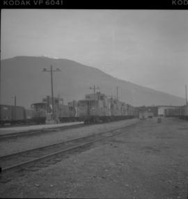
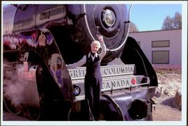
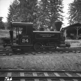
Photograph depicts locomotive #24 "Susie" at the Cowichan Valley Forest Museum. It has a 3' gauge. The last known owner before acquisition by G. Wellburn was the Elk River Collieries Ltd.
Handwritten photo album caption below this photo reads: "This 'Nose' holds a lot." Photograph depicts four men in uniform loading a red cross suitcase onto the nose of a plane. Airstrip, snow, trees and hills in background.
Royal Canadian Air ForcePhotograph depicts a loading spur on the B.C. Electric Railway at Jackman St. (or nearby), 10 miles east of Langley. The view is looking east.
Photograph taken on the CPR branch from Vernon to Lumby. Depicts loading poles at Gorman Bros Ltd.
Handwritten photo album caption below this photo reads: "Everybody Works." Photograph depicts four men in uniform (same men from item 2006.20.12.33) loading a red cross suitcase and other luggage onto plane, movable staircase behind them. It is believed that a fifth man is also semi-visible behind them. Snowbank and various unidentified buildings in background on right.
Royal Canadian Air ForcePhotograph depicts five men loading packed bags into a long boat belonging to Mac McGarvey. The boat is resting near the shore of an inlet at Rolla Landing.
Six men visible on hillside and wood plank roadway, working together to roll cut logs down the hill and load them onto the truck.
Handwritten annotation in pencil on verso read: “logs up to 32 feet in length.”
Photograph depicts six men by building on shore. One man sits in small boat that has been loaded onto a wagon. River and opposite shore in background. Handwritten annotation on verso of photograph: "Loading for the Peace River." Photograph believed to have been taken either at Giscome Portage, or the trading post at Summit Lake, BC.
Photograph depicts five men in uniform loading supplies onto a military plane with the number "7632" on its side. Handwritten photo album caption below this photo reads: "LOADING FOR THE NORTH." It is believed this photograph was taken at the military base in Whitehorse, YT.
Royal Canadian Air ForcePhotograph depicts loading coal at Buckley Bay. Coal is from Tsable Mine belonging to the Comox Colliery Co. The view is looking north.
View of a scow loaded with provisions and several people passing through rapids of the Grand Canyon. Printed annotation on recto reads: “A scow loaded with provisions passing through the Grand Canyon on it’s way to Fort George.” Handwritten annotation in pencil on recto reads: “Nearly Bumped, Nachaco River” Handwritten annotation in pencil on verso reads: “My address will be Fort George BC. Dear Mrs. Cooper, I am up in the wild part of BC now where men horses and everything get drowned every day, sometimes automobiles get drowned also. This is the way we travel up where I am now. I saw a boat upside down in this Canyon it had a bundle of blankets tied on it and one oar was dancing in the whirlpool. This made my hair stand straight up and down.”
Photograph depicts the Lions Gate (suspension) Bridge.
Photograph taken from a small hill looking down on a crowd of men gathered around the Grand Trunk Pacific railway tracks in the winter. Printed annotation on recto reads: "Linking up of Steel on G.T.P. Transcontinental 1914."
The last spike ceremony was held on April 7, 1914 one mile east of Fort Fraser, BC.
Photograph depicts a line of cabooses on the caboose track at Revelstoke. There are rumours that the vehicles are to become obsolete by replacing them with a monitoring device attached to the last car of a train.
Photograph depicts a car crossing the Lillooet Suspension Bridge (also known as the Lillooet Old Bridge) over the Fraser River.
Photograph depicts the the Lillooet River Bridge north of Pemberton, BC. Mt. Currie is visible in the background.
Image depicts a hotel in Likely, B.C.
Image depicts numerous vehicles and individuals outside a hotel in Likely, B.C.
Front of engine reads "BRITISH COLUMBIA, CANADA", "2860". Decorated building stands in left background. A man with large video camera and an RCMP officer in a red serge can be seen standing in crowd. Mountain peak visible in distance.
Front of engine reads "BRITISH COLUMBIA, CANADA". Building and construction area visible in background.
Image depicts a building, possibly an office building, next to a set of rail road tracks in Leo Creek, B.C. An unknown individual is present, and a number of barrels and culverts are visible in the foreground.
Image depicts several individuals seated on a ferry as it possibly departs from a dock somewhere in Prince Rupert, B.C. It is most likely headed for Haida Gwaii, B.C.
Image depicts numerous boats docked by the Prince Rupert Fishermen's Co-operative Association from the deck of a ferry, possibly as it's leaving Prince Rupert, most likely for Haida Gwaii.
This clip of original film footage depicts Pacific Great Eastern Railway (PGE) track laying in Northern British Columbia.
Dock in foreground, ship in water, mountain in background. Unidentified men partially visible in foreground. Printed annotation on recto reads: “Launching of Canadian Scottis –CGM.M. 5500, ton ship at Prince Rupert B.C.”
Photograph depicts men standing on different deck levels of conveyor on the Fraser River. Wood planks built into shore in foreground, trees on opposite shore in background. Handwritten annotation on verso of photograph reads: "Launching Conveyor", on recto: "Launching the rebuilt steamer Conveyor at Tete Jaune 1912".
Photograph depicts the last spike at Craigellachie, 15 miles northeast of Sicamous, looking southwest.
View from of a large ship in dry dock surrounded by water. Printed annotation on recto reads: “G.T.P. Dry dock Prince Rupert B.C. McRae.”
Photograph depicts large fish laid next to a metal L ruler. Fish rests on dark wood speculated to be inside of boat or box of truck. It is believed this photo was taken at Summit Lake, B.C.
Large crowd is gathered around main building in a harbor. Many boats visible in foreground. Smoke from tugboat partially obscures the scene. Annotation on recto reads: "Prince Rupert BC. Photo by MCrae Bros."
Image depicts a large building with numerous vehicles in the foreground.
Photograph depicts long bridge over river. Closest pier in left foreground, opposite shore in background.
Photograph depicts "Landing Craft #10," of the B.C. Provincial Forestry Service.
Image depicts a camper on the shore of what is possibly Melita Lake, near the Tseax Cone.
Photograph depicts Lake Cowichan. Trackage that is unconnected is visible in the foreground. Depot itself is a house and a rail museum combined. It was closed at the same time as the Honeymoon Bay mill. Permission was given to close the 18 mile brand line on November 13, 1984. Track lifting commenced on November 20, 1984.
Photograph depicts disused cars on the CPR spur just north of the crossing between the Esquimalt & Nanaimo Railway and Comox Logging and Railway Company (Division of Crown Zellerbach Canada Ltd.)
Photograph depicts the Ladysmith diamond crossing, looking north from the highway. Esquimalt & Nanaimo Railway is visible on the right and in the centre. On the left are the Comox Logging and Railway Company lines. Strings of disused log cars are on the centre tracks and are owned by CPR.
Photograph depicts the crossing between the Esquimalt & Nanaimo Railway (the camera is facing these tracks) and Comox Logging and Railway Company. The guard tower was manned at 7:00 p.m. and had its roof recently reshingled. It faces southward.
Photograph depicts disused log cars standing on spurs immediately north of the crossing between Esquimalt & Nanaimo Railway and Comox Logging and Railway Company. Both track cars are owned by CPR. Note: protection signals are located on the right. The camera is aimed towards the north.
Photograph depicts the a sign about 200 yards away from depot aadjacent to the Island highway. It was probably erected within the last 9 months as a result of the Canadian Transport Commission's investigation of the Esquimalt & Nanaimo Railway in late 1970. Amongst the other structures there is a lack of sign posting, dirty and unkept stations, and active discouragement of passenger traffic.
Photograph depicts an island and ferry at the "Kwuna" ferry landing at Sandspit, Queen Charlotte Islands.
Photograph depicts the "Kwuna" ferry coming in to dock at the landing at Sandspit, Queen Charlotte Islands.
Photograph depicts the "Kwuna" ferry about to dock at the landing at Sandspit, Queen Charlotte Islands.
Photograph depicts the "Kwuna" ferry coming in to the landing at Sandspit, Queen Charlotte Islands.
Photograph depicts the "Kwuna" Ferry from the wharf at Sandspit, Queen Charlotte Islands.
Image depicts the Kwinitsa CNR station, which is Prince Rupert's railway museum.
Image depicts the Kwinitsa CNR station in Kwinitsa, along the Skeena River.
Photograph taken looking east, towards the depot and town of Princeton. Behind the yard lay the beginnings of the former Copper Canyon branch.