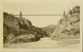
Print preview Close

Showing 3113 results

Archival description
Old Trestle
2012.13.1.100.22 · Item · 1999
Part of J. Kent Sedgwick fonds

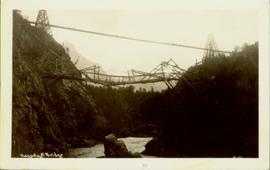
Image depicts an old trestle along the White Pass railway, and the White pass Train on the left of the image.

Old Slump
2012.13.1.50.064 · Item · 1978
Part of J. Kent Sedgwick fonds

Image depicts an old slump type of landslide. The slide labels it as being near "McAlister."

Old Mill?
2012.13.1.50.157 · Item · [1982?]
Part of J. Kent Sedgwick fonds

Image depicts what appears to be an old mill at an unknown location.

Old House in Sinclair Mills
2012.13.1.87.019 · Item · [between 1975 and 1995]
Part of J. Kent Sedgwick fonds

Image depicts an old house missing windows and doors in the foreground, and a bunkhouse in the background, in Sinclair Mills, B.C. Map coordinates 54°01'17.4"N 121°40'53.0"W

Old House in Penny, B.C.
2012.13.1.87.119 · Item · [between 1970 and 1990]
Part of J. Kent Sedgwick fonds

Image depicts an old house in Penny and a woman, possibly Sue Sedgwick, standing in front of it. The location is uncertain.

Old House
2012.13.1.87.118 · Item · [between 1970 and 1990]
Part of J. Kent Sedgwick fonds

Image depicts an old house with a torn up roof. The location is uncertain.

Old House
2012.13.1.87.018 · Item · [between 1975 and 1995]
Part of J. Kent Sedgwick fonds

Image depicts an old house missing windows and doors at an uncertain location.

2009.7.1.314 · Item · [ca.1880-1920]
Part of Archdeacon W. H. Collison fonds

Photograph of a long bridge spanning two rock faces. Below is a smaller, half demolished wooden bridge. A small settlement is visible on the lower right. Annotation on recto reads: "Haquelqet Bridge." Handwritten annotation on verso reads: "Old & New. Old Indian built bridge & later one at Hazelton, BC."

Oddly Shaped Tree Branch
2012.13.1.78.40 · Item · 1982
Part of J. Kent Sedgwick fonds

Image depicts an oddly shaped tree branch that appears to have grown downwards, and is covered in green, mossy growths. Located somewhere on Haida Gwaii.

Northwood Pulpmill
2012.13.1.3.160 · Item · Nov. 2000
Part of J. Kent Sedgwick fonds

Image depicts the Northwood Pulpmill in Prince George, B.C. taken from above the Nechako River looking east. Map coordinates 53°56'00.0"N 122°44'29.7"W

North Peak Strip Mining
2000.1.1.3.13.10 · Item · [1961?]
Part of Cassiar Asbestos Corporation Ltd. fonds

Photograph depicts the North peak of McDame mountain after extensive strip mining, South peak unmined in background. Old mine garage visible on right of West peak in foreground. Crusher plant partially visible on far right. Photograph believed to have been taken just prior to the development of the pit mine between the North and West peak.

Newlands?
2012.13.1.89.028 · Item · Mar. 1975
Part of J. Kent Sedgwick fonds

Image depicts what is possibly the community of Newlands, B.C.

Nechako River?
2012.13.1.23.08 · Item · 1973
Part of J. Kent Sedgwick fonds

Image depicts what is possibly a small section of the Nechako River on Cottonwood Island.

Nechako River?
2012.13.1.22.19 · Item · 1970
Part of J. Kent Sedgwick fonds

Image depicts a body of water in Island Cache. It is possibly a small section of the Nechako River.

Nechako Cutbanks Trail
2012.13.1.3.092 · Item · 12 Oct. 1989
Part of J. Kent Sedgwick fonds

Image depicts the cutbanks on the other side of the Nechako, taken from the nature trail at Island Cache. Map coordinates 53°55'34.6"N 122°45'52.4"W

Nechako Cutbanks Trail
2012.13.1.3.091 · Item · 12 Oct. 1989
Part of J. Kent Sedgwick fonds

Image depicts the cutbanks on the other side of the Nechako, taken from the nature trail at Island Cache. Map coordinates 53°55'34.6"N 122°45'52.4"W

Nechako Cutbanks
2012.13.1.3.090 · Item · 12 Oct. 1989
Part of J. Kent Sedgwick fonds

Image depicts the cutbanks on the other side of the Nechako, taken from the nature trail at Island Cache. Map coordinates 53°55'34.6"N 122°45'52.4"W