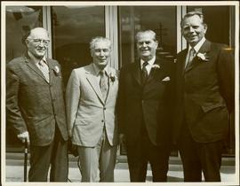
Print preview Close

Showing 3218 results

Archival description
Open Field in Giscome
2012.13.1.87.069 · Item · [between 1975 and 1995]
Part of J. Kent Sedgwick fonds

Image depicts a field in Giscome, B.C. On the right side of the image, in the background, is a grey strip that appears to be a mine, possibly the quarry at Eaglet Lake in Giscome, B.C. Map coordinates 54°03'52.9"N 122°22'10.0"W

Open Field in Giscome
2012.13.1.87.068 · Item · [between 1975 and 1995]
Part of J. Kent Sedgwick fonds

Image depicts a field in Giscome, B.C. On the right side of the image, in the background, is a grey strip that appears to be a mine, possibly the quarry at Eaglet Lake in Giscome, B.C. Map coordinates 54°03'52.9"N 122°22'10.0"W

Open Field in Giscome
2012.13.1.87.163 · Item · [between 1975 and 1995]
Part of J. Kent Sedgwick fonds

Image depicts an open field and Giscome, B.C. in the background. Map coordinates 54°03'52.9"N 122°22'10.0"W

Open Cab Truck
2005.3.62 · Item · [ca. 1946]
Part of John Hart Highway Photograph Collection

Handwritten caption beside this photo reads: "1500wt 4x4". Photograph depicts small open cab truck with tire chains. Forest and unidentified buildings in background. A second vehicle is semi-visible on far left, as well as a pile of logs on far right.

Old Warehouse
2006.20.11.9 · Item · June 1923
Part of Northern BC Archives Historical Photograph Collection

Photograph depicts a large two story building in fenced area. Field spans foreground, stand of trees in background. Handwritten photo caption below photograph reads: "The old warehouse." It is believed that this photograph may have been taken at Fort St. James, BC.

Old Trestle
2012.13.1.100.22 · Item · 1999
Part of J. Kent Sedgwick fonds

Image depicts an old trestle along the White Pass railway, and the White pass Train on the left of the image.

Old mine buildings
2013.6.36.1.077.01 · Item · 13 Sept. 1970
Part of David Davies Railway Collection

Photograph depicts one of various old lead and zinc mine buildings. Behind this building, on the foreshore, were a few men working on the reclamation of tailings and waste from the mine that was dumped in Kootenay Lake.

Old Mill?
2012.13.1.50.157 · Item · [1982?]
Part of J. Kent Sedgwick fonds

Image depicts what appears to be an old mill at an unknown location.

Old House in Sinclair Mills
2012.13.1.87.019 · Item · [between 1975 and 1995]
Part of J. Kent Sedgwick fonds

Image depicts an old house missing windows and doors in the foreground, and a bunkhouse in the background, in Sinclair Mills, B.C. Map coordinates 54°01'17.4"N 121°40'53.0"W

Old House in Penny, B.C.
2012.13.1.87.119 · Item · [between 1970 and 1990]
Part of J. Kent Sedgwick fonds

Image depicts an old house in Penny and a woman, possibly Sue Sedgwick, standing in front of it. The location is uncertain.

Old House
2012.13.1.87.118 · Item · [between 1970 and 1990]
Part of J. Kent Sedgwick fonds

Image depicts an old house with a torn up roof. The location is uncertain.

Old House
2012.13.1.87.018 · Item · [between 1975 and 1995]
Part of J. Kent Sedgwick fonds

Image depicts an old house missing windows and doors at an uncertain location.

O'Keefe Ranch
2013.6.36.1.078.03 · Item · [July 1966]
Part of David Davies Railway Collection

Photograph taken at Okangan Lake, on Alexis Beach. O'Keefe Ranch is located at the head of the lake. Visible is an old house that was used as a hay barn.

2006.20.12.21 · Item · [ca. 1940]
Part of Northern BC Archives Historical Photograph Collection

Handwritten photo album caption below this photo reads: “Officers' Quarters, Ft St John.” Photograph depicts two men standing in distance at doorway of officers' quarters, wood slat sidewalk in foreground. Fence and trees on horizon in background, dirt pile to right of building. The two men are believed to be Captain Read (2006.20.12.17) and the man in charge of general duties (item 2006.20.12.15).

Royal Canadian Air Force