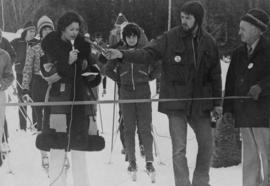
Photograph depicts Skeena MP Iona Campagnolo speaking into a microphone to open the National Cross-Country Ski Championships in Burns Lake. Skiers stand behind the starting line.
Photograph of three unidentified people, Joe Daniels, J.B. [?], Iona Campagnolo, and an unidentified man sitting at a table (see also item 2009.6.1.98).
Handwritten annotations on verso read: “Oct 16/74,” and “Kitwanga, BC, November 11th/74 tour”.
Handwritten annotation on verso reads: “Left to Right: Leonard Bright; Joe Daniels (chief) J.B.; I.C., Richard Morgan; Howard Morgan, Kitwanga, B.C., November 11/74 tour”.
Campagnolo makes a speech from podium at banquet as three unidentified men, an unidentified woman, and Jeanne Sauvé clap; all are standing behind the banquet table with a Canadian flag in the background.
Handwritten annotations on verso read: “copie pour Mme Campagnolo,” and “6”
Head shot of Campagnolo at political function.
Typed label affixed to verso reads: “Campagnolo, Iona, Skeena”; handwritten annotations on verso read: “Gillette Lecture 1974,” “B-7”.
Photograph depicts Skeena MP Iona Campagnolo listening to Jamie Sterritt at BC Federal Liberal Caucus meeting in Terrace.
Handwritten annotations on verso read: “Le “Gang” Louis Hebert, Denis Dawson, Lise St. Martin Tremblay,” and “film A”. Photograph taken in the riding of Louis-Hébert, Quebec.
Photograph depicts Moyie Lake, 15 miles south of Cranbrook, and Moyie Station. The tailings are from a lead and zinc mine directly to the right of the photograph on the hillside. The view is looking north.
Photograph of a large explosion on a rocky shoreline. A bridge is visible in the foreground and a body of water is partially visible in the background. Printed annotation on recto reads: "McRae Bros Moving Mountains at Prince Rupert BC Apr 24th" Handwritten annotation on verso reads: "Rupert. July 17 1913. Dear [illegible]. Just a card for that album if you've got any room left by now. This is one of the blasts for the clearing of the drydock up here. [Illegible] W.M." Postcard is addressed to: "Miss C.M. Ranip[??] 931 Northlane Av.[sic] Seattle Wash." Two Canadian one cent stamps are affixed on verso. Postmark reads: "Prince Rupert BC. PM Jul 17 13."
Photograph of a large explosion on a rocky shoreline. A bridge is visible in the foreground and a body of water is partially visible in the background. Annotation on recto reads: "McRae Bros Moving Mountains at Prince Rupert BC Apr 24th"
Photo depict Movat's store where you could buy food, dry goods, and hardware among other things. Located beside the original pier on Salt Spring Island, now little used for general and commercial traffic.
Photograph depicts the mouth of the Nass River with a flock of birds flying over the water, snow capped mountains in the distance. Handwritten annotation below photograph reads, "mouth of the Naas at Black Point, BC". Location is: Latitude. 54.9829
Photograph depicts a three mounted soldiers with a pack horse in front of a stone building, possibly somewhere between Bella Coola and Anahim Lake during the WWII Polar Bear training exercise. Another man and a woman stand in the background near a truck and a flagpole.
Photograph depicts a valley in the Kutcho Creek area with an exploration camp in the distance at the foot of a hill. The camp was set up by a crew led by Cassiar's Chief Geologist Bill Plumb.
Photograph depicts a view looking across an expanse of water toward treed mountains with snowy peaks.
Photograph depicts an expanse of water, on the shore are low treed hills and snow peaked mountains in the distance.
Image depicts a field and a shack in the foreground and mountains in the background. The location is uncertain, likely Longworth, B.C.
Image depicts a mountain range located somewhere along the Skeena River.
Image depicts what is either the Rocky Mountains or possibly the Columbia Mountains, from McBride, B.C.
Image depicts a mountain range "east of Driftwood," possibly meaning the Driftwood Canyon Provincial Park east of Smithers, B.C.
Image depicts a mountain somewhere in Bear Glacier Provincial Park.
Image depicts numerous mountains surrounding the Bear Glacier.
Photograph depicts a mountain vista seen through a stand of trees.
Photograph depicts a mountain vista seen through tall coniferous trees.
Photograph depicts a mountain vista seen through a close perspective of trees.
Photograph depicts a mountain vista as seen over the tree tops of a densely forested environment.
Photograph depicts mountains in background behind forest trees. River barely visible behind bushes at bottom of photo. Handwritten photo caption on verso and recto of this photograph reads: "On the Clearwater."
Item is a photograph of J.R.M. kneeling in front of a cairn surveying station beside two pack dogs.
Location identified as upper Torrens basin.
Image depicts a rock formation on a mountain side at an uncertain location.
Photograph depicts a mountain ridge rising out of an alpine lake. The photograph location is the Mt. Petrie area from the north and northwest.
Photograph depicts a mountain ridge rising our of an alpine lake that is visible in the foreground. The photograph location is the Mt. Petrie area from the north and northwest.
Photograph depicts a mountain range visible across a wide-river with trees in the foreground.
Photograph depicts snowy mountain tops viewed from the forest and valley floor.