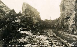
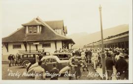
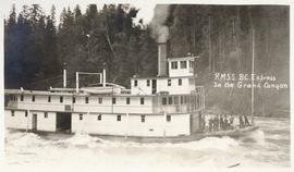
Postcard image of RMSS "BC Express" in Grand Canyon, Fort George
Image depicts a road with what appears to be a junkyard to the right of the image, likely located somewhere in Seton Portage, B.C.
Image depicts a mountain located somewhere along the Skeena River, and a road alongside it.
Photograph depicts the road and rail bridges at New Westminster, BCView is from the north and facing upstream.
Photograph depicts a car parked on the road between Kaslo and New Denver, on the site of a former railway right-of-way.
Photograph depicts the road bridge crossing the south section of the north arm of the Fraser River at Fraser St. The view is from the north bank of Lulu Island.
Photograph depicts a road bridge at Squamish B.C., looking north onto the road leading into the village.
Photograph depicts a road bridge at Squamish B.C. from the north bank.
Photograph depicts a bridge for road vehicles. Also visible is a single track of the CPR that went from Esquimalt to Nanaimo.
Photograph depicts a bridge for road vehicles. Also visible is a single track of the CPR that went from Esquimalt to Nanaimo. Both were opened to allow a large tug to proceed seawards.
Photograph depicts the road bridge crossing over the Kootenay River at Fort Steele, 10 miles northwest of Cranbrook, looking downstream. Two piers of a new bridge can be seen behind the present one. The railway is from Golden to Fernie and built in approximately 1913.
Photograph depicts a road bridge that led from Fort Langley to a ferry slip on an island.
Photograph depicts a road bridge in Quesnel.
Photograph depicts the road bridge over Toby Creek, just north of Invermere or 75 miles north of Cranbrook, looking at upstream piers.
Photo depocts a road bridge in the Inner Harbour of Victoria.
Photograph depicts a road crossing somewhere on the "loops" on the Princeton to Jura line. Looking downgrade at a loop.
Photograph depicts the uppermost crossing before Jura. Davies noted that though it was not listed on any timetable, it was believed that there was a waiting shed on the left side of the track beyond the road. Note the generous width of the railway property beyond the road that was possibly for putting in a level spur.
Photograph depicts the uppermost crossing before Jura.
Photograph depicts a road crossing leading to the Forestry Department campsite at the south end of Hydraulic Lake. The location is about 1 mile south of McCulloch depot or at about mill 75.5, on the Carmi Subdivision. The rail here is 85 lbs. and dated 1940. The view is looking west.
Photograph depicts a road crossing somewhere on the "loops" on the Princeton to Jura line.
Photograph depicts a road roader at work doing black top patching and that belonged to the Pavements Department of the City of Vancouver. Built by Aveling Barford Ltd., Grantham, Lincs, England.
Image depicts the dirt road leading to Keithley Creek.
Image depicts a road leading to Prince Rupert, B.C.
Image depicts the road to Skagway, Alaska. Possibly located on the Klondike Highway in British Columbia with Tutshi Lake on the left.
Photograph depicts a road trestle bridge for cars about halfway between south Wellington and Nanaimo Lake, southwest of Nanaimo.
Photograph depicts road vehicles parked outside of the CPR depot in Salmon Arm.
Photograph depicts the making of a rock cut on the Pacific Great Eastern Railway line at the Lillooet end of Seton Lake during railway construction.
Photograph depicts men on river scow, large rock island or peninsula protruding into river behind them. Trees on opposite shore in background, large rock in foreground. Handwritten annotation on verso of photograph: "Grand Canyon. Fraser River. Big Rock.", on recto of copy print: "1911."
Photograph of a large crowd gathered at the McBride train station. Printed annotation on recto reads: "'Rocky Mountain Rangers Band, McBride, B.C.'"
Photograph depicts a Rocky Mountaineer train with a propelling locomotive short distance away approaching Chilcoltin Road, Kamloops Indian Reserve. St. Joseph's Church is on the left.
Photograph depicts a Rocky Mountaineer train with a propelling locomotive short distance away approaching Chilcoltin Road, Kamloops Indian Reserve.
Photograph depicts a Rocky Mountaineer train proceeding westward onto the North Thompson bridge. It was then propelled down to the branch to downtown Kamloops.
Photograph depicts a southbound Rocky Mountaineer train coming into the CN Kamlops Junction. Included about 8 empty cars.
Photograph depicts a work in progress in extending access to a new depot for Rocky Mountaineer Rail Tour trains.
Photograph depicts a southbound Rocky Mountaineer train coming into the CN Kamlops Junction. Included about 8 empty cars.
Photograph depicts a Rocky Mountaineer Jasper train that had just been propelled into the downtown Kamloops CN station. Once passengers de-trained, the empty train was pulled into R.M.R private trackage on K.I.R. for overnight stabling, cleaning, and restocking.
Photograph depicts cars of the Rocky Mountaineer Rail Tours. Believed that the year the photograph was taken was the first that cars of the company were stored in Kamloops as before they were stored in Vancouver. The initial experience was bad because there was an unseasonable cold snap in November and December that froze all the batteries underneath the cars and ruined them (bursting occured).
Photograph depicts the sidings of the Rocky Mountaineer Railway Tours CN depot in downtown Kamloops.
Photograph depicts a Rocky Mountaineer Rail Tour train passing a newly completed yard.
Photograph depicts a completed yard of the Rocky Mountaineer Rail Tours built on the Kamloops Indian Reserve, about 1 1/4 miles northeast of the VIA waiting room at the CN Kamloops Junction.
Photograph depicts the Rocky Mountaineer Rail Tours yard. Main line track is found on the left and was still used by CN for Okanagan freights and other miscellaneous trafffic.
Photograph depicts the Rocky Mountaineer in downtown Kamloops.
Photograph depicts the Rocky Mountaineer in downtown Kamloops. Locomotive #7488.
Photograph depicts rolling stock on a spur trestle at the Cowichan Valley Forest Museum on Somenos Lake.