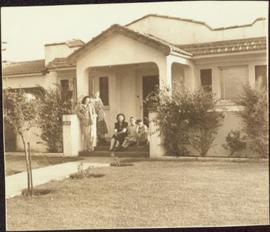
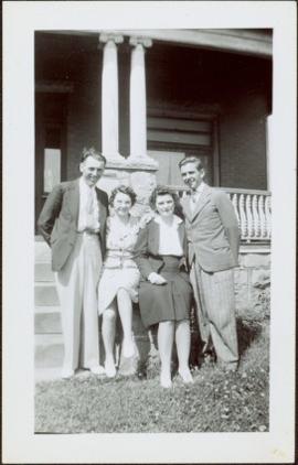
Print preview Close

Showing 3211 results

Archival description
3211 results with digital objects Show results with digital objects
2009.7.1.102 · Item · [ca. 1878 - ca. 1915]
Part of Archdeacon W. H. Collison fonds

Photograph depicts a totem pole supported by smaller poles, and a second totem pole standing straight in background. Beach in foreground, fence and hills in distance.

Handwritten annotation on verso reads: "Falling greatness, Chapt. XXI No. 5, A Chief's Totem Pole inclined to fall. [Gitaix?] Encampment, Nass River. Five illustration for Chapt. XXI."

Exhibition Sports Centre
2012.13.1.7.234 · Item · Mar. 2003
Part of J. Kent Sedgwick fonds

Image depicts the Exhibition Sports Centre, which used to be a drill hall army base, on Keller Street in Prince George, B.C.

Exhibition Sports Centre
2012.13.1.7.244 · Item · Mar. 2003
Part of J. Kent Sedgwick fonds

Image depicts the Exhibition Sports Centre, which used to be a drill hall army base, on Keller Street in Prince George, B.C.

Europe Hotel
2012.13.1.7.178 · Item · Dec. 1999
Part of J. Kent Sedgwick fonds

Image depicts the Europe Hotel in Prince George prior to its demolition in the 1980s; however, the slide itself was only made in 1999 and the date of the photo is otherwise unknown, but most likely around 1979.

Endako
2012.13.1.51.086 · Item · Oct. 1975
Part of J. Kent Sedgwick fonds

Image depicts a train passing through Endako, B.C.

2011.3.3.65 · Item · 11 June 1915
Part of North Coast & Central BC Postcard Collection

Elevated photograph of Prince Rupert taken from a hill. Printed annotation on recto reads: "Prince Rupert BC McRae Bros." Handwritten annotation on verso reads: "11/June c/o PG Prince Rupert, B.C. Dear Rae[??], How about a letter. Love for all, Frank." Postcard is addressed to: "Miss R Boew. Bernie PG [illegible]." Postmark on verso reads: "Prince Rupert BC Jun 11 1 PM 1915."

2013.6.36.1.028.11 · Item · 17 Sept. 1970
Part of David Davies Railway Collection

Photograph depicts the CPR line at Eholt, located at mile 108.7 from Nelson on the Boundary Subdivision. It was a formerly bustling junction with the left-hand spur leading to Phoenix. Nor it only has 3 way freight trains a week from Nelson to Midway. The view is looking west.

2009.7.1.067 · Item · [ca. 1873 - ca. 1920]
Part of Archdeacon W. H. Collison fonds

Photograph depicts town buildings on opposite shore. Beach and dock can be seen in foreground.

Handwritten annotation on verso reads: "Chapter XXII, No 1. Eastern Section of Port Simpson as christianized."

2009.7.1.304 · Item · [ca. 1880-1920]
Part of Archdeacon W. H. Collison fonds

Photo of the Prince Rupert harbour. Many buildings are visible along the shoreline. Annotation on recto reads: "Harbour, Prince Rupert BC. 1658." Handwritten annotation on verso reads: "Early Prince Rupert. Good view of Metlakatla Passage in distance- showery[?] Wolf Island."

2000.1.1.3.24.02 · Item · Septmeber 1954
Part of Cassiar Asbestos Corporation Ltd. fonds

Photograph depicts wood houses behind stand of trees in Cassiar valley. Truck, power poles, and road in foreground, mountains in background. Typed caption below photo in original duotang album: "Two Bedroom Pan-Abode Houses - Cassiar Townsite". Handwritten annotation on verso: "Sept 1954".

2000.1.1.3.13.13 · Item · 1959
Part of Cassiar Asbestos Corporation Ltd. fonds

Photograph depicts the North peak of McDame mountain in the earlier stages of strip mining, South peak unmined in background. Quonset and other shops visible in left foreground, unknown building built into mountainside in right foreground.

2009.7.1.288 · Item · July 1911
Part of Archdeacon W. H. Collison fonds

Photograph of several commercial and residential buildings, including the church and "The Big Furniture Store." Annotation on recto reads: "Prince Rupert. BC Allen Photo July '11." Handwritten annotation on verso reads: "Early day- Prince Rupert."