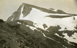
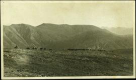
Photograph depicts Knox McCusker’s pack train traversing across an unidentified mountain ridge, ca. 1930. Caption on verso reads: “Knox McCusker’s pack train, ‘30’s”.
Photograph depicts Knox McCusker holding a fish outside a survey camp tent. Caption on verso reads: “Well say! Betty! A Toad River Indian”. It is believed this photo was taken at Tuchadi Lake.
Photograph depicts a view from the Klemtu Lake outlet toward the sea with a cleared site for the proposed powerhouse.
Image depicts a row of totem poles in Kitwanga, B.C.
Image depicts a totem pole in Kitwanga, B.C.
Image depicts an old Hudson Bay Company house in Kitwanga, B.C.
Image depicts an old Hudson Bay Company house, with a totem pole in the foreground, in Kitwanga, B.C.
Image depicts a row of totem poles in Kitwancool, B.C.
Image depicts a totem pole in Kitwancool, B.C.
Image depicts several old totem poles on their sides in Kitwancool, B.c.
Image depicts two old, overgrown and collapsing buildings, as well as a metal frame; it is located somewhere in Kitwancool, B.C.
Image depicts numerous houses in Kitwancool, B.C.
Image depicts the interior of an old, collapsing log building in Kitwancool, B.C.
Photograph depicts view of Kitseucla mountain summit with snow patches and a rocky peak.
Photograph depicts Kitseucla creek, trees and a mountain peak in the distance.
Image depicts a view of the forest and lake around Kitimat, B.C.
Image depicts a row of houses somewhere in Kitimat, B.C.
Image depicts a man holding two fish on a dock in Kitimat, B.C.
Image depicts a harbour in Kitimat, B.C.
Image depicts numerous docked boats in Kitimat, B.C.
Image depicts numerous businesses, such as the Bay, Overwaitea, and Dairy Queen, somewhere in Kitimat, B.C.
Image depicts several buildings in Kitimat, with the Bay being the tall one on the left.
Image depicts numerous docked boats, as well as many houses on the shore in the background; located in Kitimat, B.C.
Image depicts what is possibly the Alcan smelter in Kitimat, B.C.
Image depicts a view of the area surrounding Kitimat, with power-lines in the foreground the city partially visible in the distance.
Image depicts the Kiteen River at Dragon Lake near Aiyansh, B.C.
Image depicts the mouth of the Kispiox River.
Image depicts numerous totem poles in Kispiox, B.C.
Image depicts an old house in Kispiox, B.C.
Image depicts a van on a narrow road, likely the Kettle Valley Trail.
Image depicts a woman walking along a trail somewhere in Kettle Valley, B.C.
Image depicts a view of Kettle Valley, with a bridge of the old Kettle Valley Rail Road visible on a slope.
Image depicts a woman walking along the trail of the Kettle Valley Rail Road.
Image depicts the trail of the old Kettle Valley Rail Road.
Image depicts a man standing on the old Kettle Valley Rail Road.
Image depicts the old Kettle Valley Rail Road.
Image depicts several unknown individuals standing on the old Kettle Valley Rail Road.
Image depicts the Okanagan Kettle Valley, with the Kettle Rail Road faintly visible among the trees
Image depicts the trail of the old Kettle Valley Rail Road.
Image depicts a woman standing on the old Kettle Valley Rail Road.
Image depicts a view of the Okanagan Kettle Valley.
Photograph depicts Kettle River canyon near Cascade, BC.
Photograph depicts a lofty view of the Kettle river near Cascade, BC.
Photograph depicts looking down on a canyon, steep cliffs on either side, a traffic bridge crosses the chasm. Near Cascade BC.