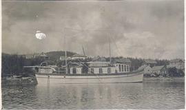
Photograph depicts the boat Westminster on the water with houses on the shoreline visible in the background. Annotation on verso of photograph states: "Westminster"
Photograph depicts the Westholme post office.
Photograph depicts a westward view from the terminal building at the Rainbow Lake Ski Club.
Photograph depicts the western portal of the C.P.R. Connaught Tunnel under Rogers Pass. The Glacier Station is a quarter mile to the rear of the camera. Fans are operated to force air through the tunnel against the direction of the trains, these therefore used for all westbound traffic. Diesel driven, steam for ancillary equipment.
Photograph depicts the "Westbridge II" tug at the Kingcome Navigation dock, Vancouver.
Photograph depicts the Westbridge CPR depot on the Kettle Valley Line. It is located about 11 miles north of Rock Creek and at about mile 123.3 east of Penticton. The depot house is disused and the sidings contained no cars, so there appears to be no local traffic.
Photograph depicts the West Summerland CPR station in the Okanagan. The station often was used but not permanently manned. It was located at mile 9.5 from Penticton. The view is looking south.
Photograph depicts the West Summerland CPR station in the Okanagan, located 9.5 miles from Penticton. The cloud in the middle distance is stone dust from a crusher on the east side of the track. The spur to the right leads to an old crusher but does not appear to be used.
This image is part of the outbound sequence of aerial images obtained on the helicopter flight to the Klutlan Glacier study site. The sequence starts from the base camp at the White River crossing on the Alaska Highway and heads south, to a point just upvalley of the debris-covered terminus (approx. 10-15 km from Alaska border), and turning back north to the landing spot on the Generc River floodplain close to the study site (see Fig. 1 in paper).
This image is part of the return trip sequence of aerial images obtained on the helicopter flight leaving the Klutlan Glacier study site. On the return leg at the end of the day, the flight initially went upvalley to pick up another party.
This image is part of the outbound sequence of aerial images obtained on the helicopter flight to the Klutlan Glacier study site. The sequence starts from the base camp at the White River crossing on the Alaska Highway and heads south, to a point just upvalley of the debris-covered terminus (approx. 10-15 km from Alaska border), and turning back north to the landing spot on the Generc River floodplain close to the study site (see Fig. 1 in paper).
Image depicts woods located west of Leo Creek, with mountains in the distance.
Photograph depicts a view of Vancouver's West End.
Photograph depicts the extreme west end of C.P.R. trackage at Coal Harbour, looking east towards the yards and downtown after a snowfall.
Photograph depicts the west end of a passing loop in Jura. Looking east.
Photograph depicts the west end of a passing loop in Jura.
Photograph depicts train cars of the West Coast Railway Association on the reversing triangle at the C.N. station in Hope. The cars are apart of the special trip from Vancouver to Hope on August 8, 1964.
Photograph depicts the West Coast Railway Association special on the Canadian National Railway (CN) trestle, immediately south of the Fraser River bridge at New Westminster, travelling east.
Photograph depicts the West Coast Railway Association on a special outing from Vancouver to Hope.
Photograph depicts a West Coast Railway Association 2-8-2 tank locomotive and tender at a C.N. station in Vancouver, B.C.
Photograph depicts a West Coast Railway Association locomotive and car at a C.N.R. station in Vancouver. The trackage actually belongs to a demolished Great Northern Railway Station.
Photograph depicts a West Coast Railway Association locomotive and car at C.N. station, ready but not permitted to steam (federal ruling).
Photograph depicts a train car that is part of the West Coast Railway Association special trip from Vancouver to Hope on August 8, 1964. It is stopped on the east side of Sumas Bridge.
Photograph depicts one of the two open C.P.R. cars located at Vancouver included in the West Coast Railway Association special trip from Vancouver to Hope. The cars stopped at Sumas Bridge for a photo halt.
Photograph depicts West Coast Electric Ltd., an electric manufacturers and shop.
Image depicts the Wells Museum in Wells, B.C.
Image depicts the Wells Hotel in Wells, B.C.
Image depicts a crowd of people outside the Wells Hotel in Wells, B.C.
Photograph depicts the old hospital building in Wells. At the time the photo was taken, 1978, it was being used as an apartment building, and that is still its current use.
Image depicts the drainage area for the Helmcken Falls in Wells Gray Provincial Park.
Image depicts the Helmcken Falls in Wells Gray Provincial Park.
Image depicts Wells, B.C.