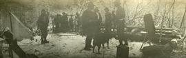
Photograph depicts several men and a dog stand on snowy ground, a canvas tent on the left. A rough hewn table on the right background.
Photograph depicts men standing on different deck levels of conveyor on the Fraser River. Wood planks built into shore in foreground, trees on opposite shore in background. Handwritten annotation on verso of photograph reads: "Launching Conveyor", on recto: "Launching the rebuilt steamer Conveyor at Tete Jaune 1912".
Dock in foreground, ship in water, mountain in background. Unidentified men partially visible in foreground. Printed annotation on recto reads: “Launching of Canadian Scottis –CGM.M. 5500, ton ship at Prince Rupert B.C.”
Image depicts a formation of rock; presumably solidified lava, as the slide is simply labelled "lava." The location of the image is uncertain.
Handwritten annotation on verso reads: "Lava plain Upper Nass River". Forest and hills visible in distance across plain.
Image depicts numerous boats docked by the Prince Rupert Fishermen's Co-operative Association from the deck of a ferry, possibly as it's leaving Prince Rupert, most likely for Haida Gwaii.
Image depicts several individuals seated on a ferry as it possibly departs from a dock somewhere in Prince Rupert, B.C. It is most likely headed for Haida Gwaii, B.C.
Image depicts a view of the Fraser Lake from Lejac, B.C.
Image depicts the BCR station in Leo Creek, B.C.
Image depicts a few piles of culverts in Leo Creek, B.C.
Image depicts a building, possibly an office building, next to a set of rail road tracks in Leo Creek, B.C. An unknown individual is present, and a number of barrels and culverts are visible in the foreground.
Photograph depicts a cluster of wooden buildings including a flagpole and church spire at a Lheidli T'enneh village site. Original photo identified this image as "Indian Village, Fort George".
Handwritten notation affixed to verso reads: “Stikine Canyon Sept 2006”.
The Lieutenant Governor stands next to bridge and highway at top of image, cliffs and white water rapids visible below.
Front of engine reads "BRITISH COLUMBIA, CANADA", "2860". Decorated building stands in left background. A man with large video camera and an RCMP officer in a red serge can be seen standing in crowd. Mountain peak visible in distance.
Trees and town can be seen from balcony, and mountains are visible across water in background. Handwritten annotation on verso reads: “Aug 2006, Her Honor, Dorothy Grant & Carole Sabiston”.
Photograph depicts a view from the ocean toward a lighthouse on a rocky ocean shore point. There are a few building near the lighthouse.
Image depicts numerous vehicles and individuals outside a hotel in Likely, B.C.
Image depicts a bridge, and the town of Likely on the the other side of a river.
Image depicts a hotel in Likely, B.C.
Image depicts Lillooet, B.C.
Image depicts a view of Lillooet, B.C.
Image depicts two bridges over the Fraser River, located somewhere in Lillooet, B.C.
Image depicts some farmland in Lillooet, B.C.
Image depicts rows of water, possibly being irrigation ditches, somewhere in Lillooet, B.C.
Image depicts a view of the mountains surrounding Lillooet, B.C.
Image depicts a view of the Fraser River and the mountains surrounding Lillooet, B.C.
Image depicts an old church located somewhere in Lillooet, B.C.
Photograph depicts a view of a river, possibly the Fraser River, canyon, mountains, and scrub land.
Image depicts an area around Lillooet, B.C. It is possibly the Fraser River running through the Moran Canyon.
Image depicts the Lillooet River at the head of Lillooet Lake.
Image depicts the Lillooet River delta at the head of Lillooet Lake.
Image depicts what is possibly the Lillooet River, full of driftwood.
Marsh along the edges of Eagle Lake features tall riparian plants and lily pads. Handwritten annotation in pen on verso reads: “Eagle Lake.”
Item is a photograph of the Lloyd Bros. Cluculz Lake Operation in April 1964.
View of a scow loaded with provisions and several people passing through rapids of the Grand Canyon. Printed annotation on recto reads: “A scow loaded with provisions passing through the Grand Canyon on it’s way to Fort George.” Handwritten annotation in pencil on recto reads: “Nearly Bumped, Nachaco River” Handwritten annotation in pencil on verso reads: “My address will be Fort George BC. Dear Mrs. Cooper, I am up in the wild part of BC now where men horses and everything get drowned every day, sometimes automobiles get drowned also. This is the way we travel up where I am now. I saw a boat upside down in this Canyon it had a bundle of blankets tied on it and one oar was dancing in the whirlpool. This made my hair stand straight up and down.”
Photograph depicts three or more men near a wagon loaded with supplies. A team of two or more horses are hitched to the wagon. Lake and rolling treed hills in the background.
Photograph depicts six men by building on shore. One man sits in small boat that has been loaded onto a wagon. River and opposite shore in background. Handwritten annotation on verso of photograph: "Loading for the Peace River." Photograph believed to have been taken either at Giscome Portage, or the trading post at Summit Lake, BC.
Photograph depicts a woman standing beside a car parked in front of the Lodge at Riske Creek in the Chilcotin. Lodge consists of a log structure which has an attached general store. Annotation on verso reads: "Risske [sic] Creek in the Chilcotin 1949".
Photograph depicts totem poles (crest poles?) in front of lodge buildings on river shore. Canoes can be seen floating in foreground, hills in background.
Handwritten annotation on verso reads: "Chapter XII. Number 1. Section of Indian Village on Nass River showing lodges and totems".
Lofty view of downtown Prince Rupert, with water and mountains in the background. Printed annotation on recto reads: "Prince Rupert, B.C."
Image depicts a log cabin and an orange truck somewhere in or near Longworth, B.C.
Photograph depicts a view of a log jam on the Kettle River from Billings siding.
Three men can be seen carrying bundles across bridge above river, forest on shore in background.
Handwritten annotation on verso reads: "Upper Nass River. Chapt. XXII. No. 4. An Indian Bridge on a canyon."
Photograph depicts a forested mountain, the bottom half of which has been logged and terraced; beneath the mountain is a railroad track and parked vehickes including a schoolbus and two dumptrucks.
Handwritten annotation on verso reads: “Fairview Sodturning, Prince Rupert, 1/3/75”.
Image depicts a logging area somewhere near Prince George, B.C.