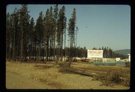
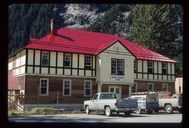
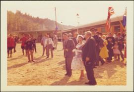
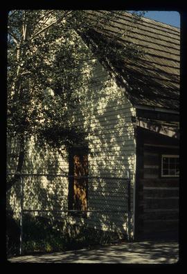
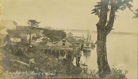
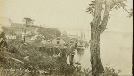
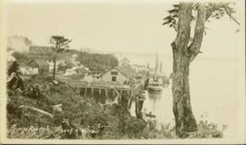
Image depicts the Hudson Bay store in Quesnel, B.C. It was built in 1859.
Image depicts the Bohanon House in Quesnel, B.C.
Image depicts numerous unknown individuals at the Bohanon House in Quesnel, B.C.
Photograph depicts railway track previously owned by BCER. It led onto the east end of Lulu Island and then to Annacis Island. Looking from the Naew West River Walk to the Queensborough bridge that was protected by signals and had a high chain link fence to deter pedestrians. It was likely that the rail was only used at night. Originally built by Canadian Northern Railway to reach Steveston, circa 1917.
Photograph taken at the University of Northern British Columbia in Prince George, B.C. Campagnolo and Weller wear full regalia, and RCMP officers can be seen in crowd.
Photograph depicts the Queen Charlotte Islands museum site overlooking Skidegate Inlet and next to a gravel beach.
Image depicts Quadra Ventures Industrial Lodge in Tumbler Ridge, B.C.
Photograph depicts a pump house on the Island Highway, north of Qualicum Beach, Vancouver Island.
Photograph depicts a Public Weigh Scale that was operated in Vancouver, on Main Street, opposite the CN Depot.
Photograph taken during European Sports Tour with Team Canada.
Image depicts the Prince George Public Library from 7th Ave.
Image depicts the Prince George Public Library.
Photograph depicts the Provincial Government Mine Rescue Station established in 1913 in Nanaimo, B.C. It is in the south side of the city.
Image depicts the Provincial Government Building located in Stewart, B.C.
Item is a photograph of Princess Margaret with Mr. Williston on her right.
Photograph of the Prince Rupert wharf. A small vessel is docked, and a large tree is in the foreground. Annotation on recto reads: "Prince Rupert Wharf & Harbor[sic]. Allen Photo."
Photograph of the Prince Rupert wharf. A small vessel is docked, and a large tree is in the foreground. Annotation on recto reads: "Prince Rupert Wharf & Harbor. Allen Photo." Handwritten annotation on verso reads: "766[?]"
Photograph of the Prince Rupert wharf. A small vessel is docked, and a large tree is in the foreground. Annotation on recto reads: "Prince Rupert Wharf & Harbor. Allen Photo."
Lofty view of the buildings along the Prince Rupert wharf with workers unloading a vessel. Water and mountains can be seen in the background. Printed annotation on recto reads: "Prince Rupert Wharf."
Street level view of the United Church in Prince Rupert BC. Printed annotation on recto reads: "Photo J.W. United Church Prince Rupert."
Photo of entire ship building plant, including several vessels in the foreground. Hills are visible in the background. Annotation on recto reads: "Prince Rupert Ship Repair and Ship Building Plant. Prince Rupert BC. Frank E Kirby, William T Donnelly, Engineers. 17 Battery Place. NYC."
Street view of Prince Rupert storefronts. A high cliff can be seen in the background with several large houses perched atop it. Printed annotation on recto reads: "Prince Rupert Residences on the Cliff which runs thru the Heart of the City." Handwritten annotation on verso reads: "8-18-24 I am still on the go but heading for home when [illegible] to be by Soft cot. Here seen some great scenery in Canada. Trains by boat to-night for Vancouver. Nan felt better. Love for all Chas[??]." Handwritten address on verso reads: "Mrs. Friderich Eley R [illegible] 3 Santa Ana Calif. U.S.A." Postmark stamped on verso reads: "Prince Rupert BC. 10 PM Aug 18 1924."
Image depicts a view of the port in Prince Rupert, B.C. The slide is labelled "superport."
Wide angle photograph of Prince Rupert sometime during the winter. There is snow on the ground and a marge mountain range is visible in the background. Annotation on recto reads: "Prince Rupert looking East from Waterworks J.D.A Pho 5/2."
Side view of the Prince Rupert in on Prince Rupert Road. Printed annotation on recto reads: "Prince Rupert Road, showing Prince Rupert Inn."
Photograph depicts the multi-level Prince Rupert hospital with trees and shrubbery in the foreground. Annotation on recto of photograph states: "Prince Rupert Hospital W.W.W. Photo"
Overhead view of the dry dock in Prince Rupert, BC. Printed annotation on recto reads: "Prince Rupert Dry Dock."
Ground level view of the Prince Rupert court house. Printed annotation on recto reads: "Court House." Handwritten annotation on recto in blue ballpoint pen reads: "Prince Rupert BC." Handwritten annotation on verso reads: "Hi Folks. Guess you've heard the good news by now. Well we've finished our cruises for this year so its home again finally to be with Marge and Janet. Will write shortly. Love Derek." Postcard is addressed to: "Mr & Mrs J.J. Oliver Box 666 Yarmouth N.S." Verso affixed with a three cent Canadian stamp. Postmark on verso reads: "Prince Rupert BC Oct 23 130 PM 1952."
Postcard featuring a car parked outside of Prince Rupert City Hall. Handwritten annotation on verso reads: "Alex Hall, Glyn P.O., Victoria, B.C. Prince Rupert, Billy S."
Image depicts a view of what is possibly a shipping yard in Prince Rupert, B.C. The slide is labelled "superport."
Image depicts the rail yards in Prince Rupert.
Image depicts an old building on the main street of Prince Rupert, B.C. Only half of the business name is visible: "Skeena Color [sic]."
Image depicts the main street of Prince Rupert, B.C.
Image depicts numerous houses on the cliff-sides in Prince Rupert, B.C.
Image depicts numerous houses in Prince Rupert, B.C.
Image depicts several houses in Prince Rupert, B.C.
Image depicts numerous houses in Prince Rupert, B.C.
Image depicts numerous buildings and a small dock somewhere in Prince Rupert, B.C. One of the buildings is labelled "Fishermen's Supply."
Image depicts a view of the downtown core of Prince Rupert, B.C.
Image depicts the City Hall of Prince Rupert, B.C.
Image depicts the Bank of Nova Scotia located on "Besner Block" in Prince Rupert, B.C.
Image depicts a view of Prince Rupert, B.C.
Wide angle photograph of a forested area with Prince George in the distance. Printed annotation on recto reads: "Prince George, B.C. 1924."
Photograph depicts the major buildings and streets of the town. Sloped cutbank visible across the Nechako River in background. It is believed that this photograph was taken from Connaught Hill. Handwritten annotation on verso of photograph reads: "PRINCE GEORGE, B.C."
Image depicts the Four Seasons Leisure Pool, and the Centennial Fountain in Prince George, B.C. Map coordinates 53°54'48.5"N 122°44'49.2"W
Image depicts the Prince George welcome and population sign, with a population of 71,086. Map coordinates 53°53'52.0"N 122°46'08.7"W