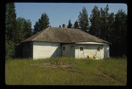
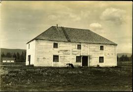
Typed annotation on recto: "Old Hudson Bay Company storhouse [sic] at Fort St. James, B.C." Cow grazing in front of a large, white, two-story building with a ladder on its roof. Wood fence, smaller second building, and forest hillside can be seen in background.
Image depicts an old house missing windows and doors in the foreground, and a bunkhouse in the background, in Sinclair Mills, B.C. Map coordinates 54°01'17.4"N 121°40'53.0"W
Image depicts an old house in Penny and a woman, possibly Sue Sedgwick, standing in front of it. The location is uncertain.
Image depicts an old house with a torn up roof. The location is uncertain.
Image depicts an old house missing windows and doors at an uncertain location.
Photograph depicts an old hotel sightseeing bus built prior to 1923. It is located at the Cowichan Valley Forest Museum.
Image depicts an old, boarded up hotel in Stewart, B.C.
Photograph depicts one of the few surviving hand operated gas pumps, halfway between Campbell River and Kelsey Bay, BCWithin three months this gas station will have electricity.
Caption describing photograph: "Old growth Douglas fir 300 yrs, 28" DBH 90' Ht. Wind shook, coarse limbed sweeping bole, heart rot, survivor of old fire. Weakly drained lacustrine deposit. Note typical of isolated distribution (single or groups occuring in Sub-Alpine zone). Very infrequent cone crops - low viability, suspect high level inbreeding. No regeneration though receptive bed. West branch, F.E.S. Aleza Lake." Harry Coates stands in the photograph for scale.
Photograph depicts an old gas station at 1603 West 3rd Ave. and Fir St. in Vancouver, BC
Photograph depicts narrow valley between steep cliffs.
Handwritten annotation on verso reads: "on left Vertical side of old Indian fort at Nagas W. Coast Q.C.I".
Photograph depicts a cluster of buildings including a church, a river in the foreground, rolling hills in the background.
Photograph depicts an old CPR passenger car at Salmon Arm. It is now in work service as #41645.
Photograph depicts old CPR passenger car at Salmon Arm. The car is now in work service as #41645 and is used for storage.
Photograph depicts an old wooden CPR caboose, formerly #436919, at Kamloops. It was built in 1928 and has sat unmoved for 2 or 3 years. By 1981 it had disappeared.
Photograph depicts old CPR boxcar #42018 at Savona, on the west end of Kamloops Lake. It was built in July 1922 and is now in work service. It has steel ends and frame but wooden sides.
Image depicts Sue Sedgwick and a dog standing next to an old, collapsing cabin which is sloped sideways. The location is uncertain.
Image depicts an old, collapsing cabin which is sloped sideways. The location is uncertain.
Photograph depicts the end of the old Coal Harbour extension of the C.P.R. line from Vancouver. It was disused for several years. The view is looking east with Woodward's Marina behind.
Photograph depicts an old church or school being demolished at 1701-1721 West 3rd Ave. (and Pine), in Vancouver, B.C.
Handwritten annotation on verso reads: "Old church - Kincolith Nass River BC".
Chicken wire crosses foreground, hills visible in background.
Image depicts several old log cabins, possibly at McLeod Lake.
Image depicts an old cabin in the woods at an uncertain location.
Photograph depicts an old business car located on a spur on the west side of the Nelson CPR depot, where it seems to be a semi-fixture. The business car was #13 and had no dates.
Image depicts a couple of old buildings, and a field full of tree trunks and dead wood. Located somewhere in or around the Upper Fraser Canyon.
Image depicts several old buildings at an uncertain location. The slide is simply labelled "Spring house?"
Image depicts several old buildings. The location is uncertain.
Photograph depicts an old building at 119 Water St. in Vancouver, B.C.
Photograph depicts a collapsed bridge on North Fork creek.
Photograph depicts a creek with banks on either side.
Photograph depicts a once used booming boat made of log sections at a log dump on seashore about 5 miles north of Powell River, and opposite Harwood Island. Stern at left with prop guard.
Image depicts an old, boarded-up school building at an uncertain location.
Image depicts an old beehive burner at an uncertain location.
Photograph of a long bridge spanning two rock faces. Below is a smaller, half demolished wooden bridge. A small settlement is visible on the lower right. Annotation on recto reads: "Haquelqet Bridge." Handwritten annotation on verso reads: "Old & New. Old Indian built bridge & later one at Hazelton, BC."
Image depicts an Anglican church in Old Aiyansh.
Image depicts a view of Old Aiyansh.
Image depicts an old, abandoned log house somewhere in Quesnelle Forks, B.C.
Image depicts an old, abandoned church located somewhere in Seton Portage, B.C.
Image depicts an old abandoned cabin at an uncertain location.
Photograph taken at Okangan Lake, on Alexis Beach. O'Keefe Ranch is located at the head of the lake. Visible is an old house that was used as a hay barn.
Photograph depicts 2 locomotives and a 2 car train, both northbound.
Photograph depicts a locomotive lettered "Central Kansas Railway" (possibly a parent company).
Photograph depicts 2 freight cars of the Okanagan Valley Railway.
Photograph depicts 2 car freight near Oyama on the CN branch from Kelowna to Vernon. The lead locomotive was lettered "Hudson Bay Railway." Central Kansas Railway may be a parent.
Photograph depicts the Okanagan CN Subdivision in Kamloops. Immediately east of Red Bridge.