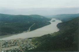
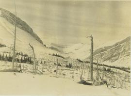
Photograph depicts a damaged tree line situated on a snow-covered mountain slope.
Photograph depicts couples dancing in large room, crowd seated on chairs against wall in background. Ornaments are hung in a row from ceiling. Man dancing in centre wears traditional dress. Handwritten annotation on recto of photograph: "Elders gathering 1983".
Photograph depicts a dancer wearing a duck mask crouching while performing on stage at Glen Vowell potluck.
Photograph depicts a dancer wearing a duck mask performing on stage with children dressed as flowers at a Glen Vowell potluck.
Photograph depicts the Giscome Rapids. Opposite shore in background, rocky beach in foreground. Handwritten photo caption on verso and recto of this photo reads: "Point where G.T.P. [Grand Trunk Pacific] canoe capsized at Giscome Rapids & where 3 men were drowned."
Photograph depicts Danny Demitr speaking with an unknown man.
Image depicts Danskin, B.C.
Image depicts a sawmill in the Danson Industrial Park in Prince George, B.C.
Image depicts a the Danson Industrial Park in Prince George, B.C.
A boat.
Photograph depicts Special Olympics athlete Daphne Pendleton on the left with an unknown woman.
Image depicts light from an unidentified light-source shining on a long, vertical object of an uncertain nature, though it is possibly a tree. The rest of the image is too dark to make out.
Item is a photograph of a little girl playing with a spoon and a tin on a sandy beach.
Caption: On the scow between Stuart Lake and Tatla Lake. Dave Hoy and family plus Bob. Item is a photograph of three men, three boys and a dog standing beside rowboats brought up on shore.
Photograph depicts utilities foreman Dave Tripp sitting at a desk.
The David Davies Railway Collection encompasses all facets of railway history specifically in the province of British Columbia and the Yukon territory. The collection consists of research material accumulated over the course of more than fifty years, and includes monographs, periodicals, articles, clippings, railway timetables, photographs, maps and plans, and excerpts. Material covers public, tourist, and private (industrial) railways, including: CPR, KVR, E&N; CNR, CNoR, GTPR; and PGER, BCR. The collection excludes material regarding streetcar systems and rapid transit, but includes long distance electric interurbans.
Photograph depicts a lake in the foreground with a possible island in the center of the photograph, low treed hills in the background.
Photograph depicts lake water in the foreground, low treed hills in the background.
Photograph depicts the bow of a boat in the foreground, lake water and low treed hills in the background.
Photograph taken in Trout Lake City which had no electricity, so the pumps displayed were hand worked. The car belonged to the Davies family. It was a 1953 Vauxhall Velox.
Photograph depicts temporary warehouse clerk Dawn McGill sitting at a desk.
Image depicts a road with a guardrail and open fields somewhere near Dawson Creek, B.C.
Image depicts a street of businesses in Dawson Creek, B.C.
Image depicts a large building which is labelled "Alberta Pool Elevators Ltd. Dawson Creek," located in Dawson Creek, B.C.
Image depicts the interior of what is possibly a heritage building in Dawson Creek, B.C.
Image depicts a street of businesses and Mile "0" of the Alaskan Highway in Dawson Creek, B.C.
Image depicts Mile "0" of the Alaskan Highway in Dawson Creek, B.C.
Image depicts the Station Museum in Dawson Creek, B.C.
Image depicts the interior of the Station Museum in Dawson Creek, B.C.
Image depicts stuffed wildlife exhibits inside the Station Museum in Dawson Creek, B.C.
Image depicts the Station Museum and the "Alberta Pool Elevators Ltd." building in Dawson Creek, B.C.
Photograph depicts a dead end stop at the CPR Penticton yard.
Image depicts a church in Deadman Creek, west of Kamloops, B.C.
Image depicts several children and numerous adults inside a church in Deadman Creek, near Kamloops, B.C.
Image depicts the corner of an old log building in Deadman Creek, near Kamloops, B.C.
Image depicts two children in front of an old log building on the Deadman Creek reserve, located west of Kamloops, B.C.
Item is a photograph of a waterfall.
Image depicts Upper Fraser residential area during demolition of town site. Map coordinates 54°06'51.6"N 121°56'26.3"W
Image depicts debris left in residential area on Giscome, B.C. townsite. Map coordinates 54°04'16.7"N 122°21'55.1"W