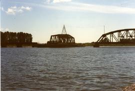
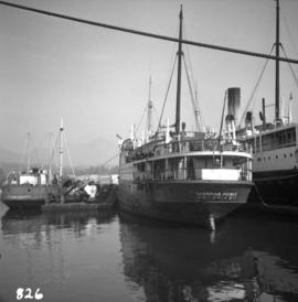
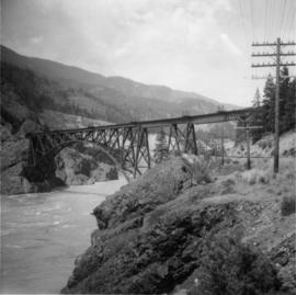
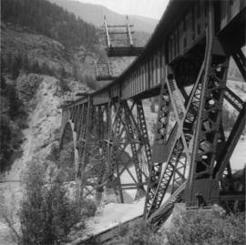
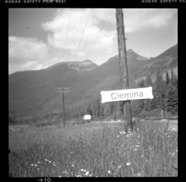
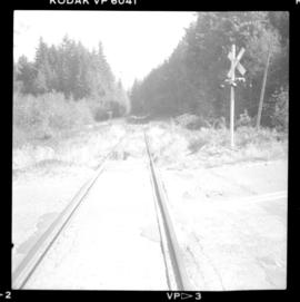
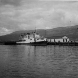
Photograph depicts a CN standby tug boat called "Pentowna," found at the CNR wharf in Kelowna. Built in 1927.
Photograph depicts a CN turntable pit in Boston Bar.
Photograph depicts a crane that had been renovated in 1993 after an accident that occurred up north Thompson. A huge rock tumbled down a creekl and overturned the crane. Taken at the Kamloops Junction.
Photograph depicts the Canadian National Railway (CN) yards at Port Mann. A wrecking crane, without a jib, and water tanker are behind.
Photograph depicts a turning wye located on the left, just beyond a hut in th middle ground. Davies spotted a continuous rail a train and a work train on a spur siding.
Photograph depicts a water tank car jacketed for protection against the weather.
Photograph depicts a CN work car. Labelled "MTN Region Maintenance of Way Training Car."
Photograph depicts a bridge over the creek beside the Mount Robson stop. It was built in 1932.
Photograph depicts an outfit spur at the Albreda Subdivision. Image captured looking upgrade towards Valemount. A work crew was working on repairing rock retaining walls.
Photograph depicts a continous rail train parked on the siding with work cars. Davies notes that it was most likely that the rail train would be laid there soon.
Photograph depicts the southern portal of a CNR snow shed.
Photograph taken at about mile 96.9 (from Jasper), Albeda Sub Division. The visible turning wye had been recently used, possibly by crate trains that Davies had spotted earlier at the location.
Photograph depicts a CN passenger car that had now become a work crew car.
Photograph depicts a derailment of a coal unit train between Basque and Martel, at about mile 63 which is approximately 15 minutes south of Ashcroft.
Photograph depicts a CNR bascule bridge across the upper waters of Victoria Harbour. The rest of the trackage had been removed, except for the bridge itself.
Photograph taken in Basque, on mile 58.5 on the CNR from Kamloops and mile 55.9 on the CPR. At this point, the tracks of the two companies are only 150 yards apart. This is the interchange line to divert traffic when the there are blockags in the canyon. The line on the left is owned by the CNR while the line on the extreme right is owned by the CPR.
Photograph taken on mile 58.5 from Kamloops. Davie notes that he found this picture to be particularly depressing as he had been there 15 months prior and took a photograph of an abandoned depot which stood where the name sign now stood on the far side of the tracks. It was right near this spot that the "last spike" was driven on the Canadian Northern Railway between Edmonton and Vancouver on 23 Jan. 1915.
Photograph depicts a former flagstop on mile 61.6 from Blue River in the Clear Water Subdivision.
Photograph depicts a former flag stop on mile 61.6 from Blue River in the Clear Water Subdivision.
Photograph depicts a CN spreader, built in 1960.
Photograph depicts a plough that was built in 1936. It was found at the depot in Blue River.
Photograph depicts a buffing post put up by "Dominion Wheel and Foundries Ltd, Toronto."
Photograph depicts a concrete pot in an elaborate station station garden that was still maintained but at a much lesser degree than in previous years.
Photograph depicts a former steam locomotive tender.
Photograph depicts a second class station built by the CNR in 1916.
Photograph depicts the depot in Blue River built in 1916. It was located at a subdivisional point.
Photograph depicts a crane, numbered 50402. Located at the CNR depot in Blue River.
Photograph depicts train #1, the Super Continental, headed westbound, that was just entering the Boston Bar depot. Image captured looking southward.
Photograph depicts a westbound train, the Super Continental, standing at the Boston Bar depot. Its engineer made no attempt to pull the passenger cars in order to face the depot. As a consequence, 3 locomotives and 4 baggage cars occupied the platform area and the rest of the cars covered the grade crossing and track to the north.
Photograph depicts a former house about 200 yards south of the depot on the eastern side of the main track.
Photograph taken at the Boston Bar depot. Image captured looking towards the north. Sign on the depot says "Restaurant" (which was defunct) and "Boston Bar: 2802 miles Montreal, 132 miles Vancouver."
Photograph depicts a westbound train, the Super Continental, standing at the Boston Bar depot. Image captured looking northward.
Photograph depicts a fire fighting tender that displays an older CNR insignia.
Photograph depicts the three long distance westbound freights being held by the Super Continetal, a westbound train.
Photograph depicts a westbound train, the Super Continental, standing at the Boston Bar depot. Image captured looking southward.
Photograph depicts a passenger train, the Super Continental. The train had stopped for a locomotive crew change.
Photograph depicts an old type of boxcar (#71139) at Canadian National Railway (CN) Kamloops Junction. It was left right beside the station to hold coal and had no building date marked on it.
Photograph depicts the CNR depot in Burns Lake. Image captured looking eastward.
Photograph depicts a CNR caboose, possibly near Boston Bar.
Photograph depicts chimney details of a CNR caboose on the Clearwater Subdivision.
Photograph depicts a CNR caboose labelled "For Engineering Use." Spotted on a spur behind several ballast cars labelled "Branch Line Rehabilitation."
Photograph depicts a spur to cattle market. A Kamloops switcher of the Kelowna Pacific Railway, painted in blue, sat in the background in its normal parking position.
Photograph depicts a CNR ship named "Canadian Prince" being gutted, with the material on the scow at left. Alongside at right is the CPR "Princess Lousie" at Lynn Terminals, North Vancouver.
Photograph taken on mile 54.1 from North Bend and about 14 miles west of Hope. Siding capacity at this location was for 120 cars. Davies notes that the location was likely to be demolished within a short time.
Photograph depicts Cisco Bridge, that crossed the Fraser River in Fraser Canyon. Looking upstream with CPR track in the lower right of the photo. 200 yards behind this photo, the CPR tack crossed the Fraser River to the west bank.
Photograph depicts Cisco Bridge that crossed the Fraser River 36 miles below Lytton in Fraser Canyon.
Photograph taken at about mile 96.9 (from Jasper), Albeda Sub Division. Davies notes that it was named after Clemina Buckle, a family friend who, at the time, was 91 years old.
Photograph taken on the line between the Deerholme Junction and Colwood (north Victoria) at about 1/4 mile north of the road that runs to north of Shawnigan Lake to Port Renfrew. The line had recently started to be used again.
Photograph taken on the CNR branchline from Cowichan Bay to Youbou. The rails are labelled "Canadian Algoma, 1924." An telegraph post stands on the right of the photo.
Photograph depicts CNR equipment that used to run any trains required on the remaining trackage of about 31 miles. A caboose, water tank car, and CN locomotive are all visible.