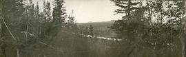
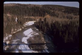
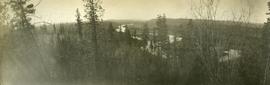
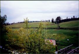
Photograph depicts landscape scene. Tree, bridge, and sign featuring cross country skier in foreground. Fence, hills, and forest in background.
Photograph depicts five men standing in a field of cut hay. Some men are holding scythes, buildings, forest and rolling hills in background.
Photograph depicts 5 men in a field using scythes to cut grain.
Pier, house, and tress with snowcapped mountains in background. Image has been cropped to oval shape. Handwritten annotation in pencil on verso reads: “Port Simpson B. C. showing magnificent background in the distance”, on recto: "W. I. O'Neill Es. Aberdeen B.C. Hope you are well my dear D.D. - Have written to K. and are sending you and [?] Boy each a card. [?] will wish to saw we are all ok. Yours, M.", "Yours 10derly". Recto stamped "PORT SIMPSON B.C. MR 14 07".
Photograph depicts a lofty view of a winding river, forest in the foreground, rolling forested hills in the background.
Photograph depicts a looking through trees to a view of a river, forested low hills in the background.
Photograph depicts a full length image of (presumably) one of Holland's survey crewmen.
Photograph depicts a river scow in midground, close to opposite shore. Handwritten photo caption on verso and recto of this photograph reads: "In the Grand Canyon."
Handwritten annotation on verso reads: "Travelling thru' canyon on Nass River 'Engine & poles'".
Hill on opposite shore in background.
Image depicts a group of unidentified individuals walking along a crevasse filled ridge somewhere in the vicinity of Smithers, B.C. The slide also labels it as a "drift ridge."
Image depicts a crevasse filling ridge somewhere in the Bulkley Valley, B.C.
Image depicts a man attaching a logging trailer to a crane on a wooden structure to stack the trailer on the truck. A Crestbrook Forest Industries sawmill is located in the background.
Image depicts a logging truck with its trailer being attached on top of it. A Crestbrook Forest Industries sawmill is located in the background.
Image depicts a row of houses and the side of a train in Crescent Spur, B.C.
Image depicts the railway running near Crescent Spur in the Rocky Mountain Trench.
Image depicts what appears to be a small mill in the community of Crescent Spur, B.C.
Image depicts a church school in the community of Crescent Spur, B.C.
Image depicts a beehive burner in the community of Crescent Spur, B.C.
Image depicts the community of Crescent Spur, B.C.
Image depicts a creek near Quesnelle Forks, B.C.
Image depicts a creek near Iron Road North, north of Woodpecker, B.C.
Photograph depicts a craggy mountain peak covered with coniferous trees and snow.
Photograph depicts large bridge and dam over a wide river, industrial structures throughout. Hills on opposite shore in background. Handwritten annotation on recto of photograph: "Coulee Dam, This is were[sic] I went this fall. Wished you had of been with me."
Image depicts a the Cottonwood Island Nature Park sign and map in Prince George, B.C.
Image depicts Elmer Mercier, a former mayor of Prince George, B.C., cutting the ribbon to open Cottonwood Park's Heritage Trail.
Image depicts a crowd of people in Cottonwood Park in Prince George, B.C.
Image depicts Cottonwood Island.
Image depicts the picnic site of the Cottonwood House Historic Site, located on the Barkerville Highway, east of Quesnel, B.C.
Image depicts the Cottonwood House Historic Site along Barkerville Highway, east of Quesnel, B.C. A sign posted by the fence reads: "For over half a century the Boyd family operated this haven for man and beast. Here weary travellers found lodging, food, and drink. Here fresh horses were hitched to stage-coaches and miners bought supplies. This historic road-house, built in 1864, stood as an oasis of civilization on the frontier of a rich new land."
Image depicts a section of the Heritage Trail on Cottonwood Island in Prince George, B.C.
Typed annotation on recto: "Cottonwood dugout on Tachi River Stuart Lake Section of B.C." Two people sit in dugout canoe, tree-covered banks in background.
Photograph depicts a narrow canyon on the Fraser River.
Photograph depicts a steamboat on the Fraser River with a full view of the paddles.
Image depicts the Cottonwood Canyon.
Photograph depicts a steamboat on the Fraser River.
Photograph depicts a view of rough river waters from the deck of a steamboat.
Image depicts a view of a river from the Cottonwood Bridge.
Image depicts a forest; the image is possibly taken from somewhere near the Cottonwood Rail Road Bridge.
Image depicts a rail road bridge, possibly the Cottonwood Bridge, at an uncertain location.
Image depicts the Cottonwood Bridge.
Photograph depicts a street scent at the corner of Laselle and Second St. in Fort George. A wagon is visible in the dirt road and wooden buildings cross the mid ground. Three unidentified men sit on the boardwalk outside Rigg's Restaurant while one man stands in the doorway of The White Laundry.
Street view of some vehicles parked in front of commercial buildings in Prince/Fort George. Businesses include "J.P. Robertson 'The Men's Store'" and "James & Co. Clothing and Shoes." Printed annotation on recto reads: "Fort George- Corner Hammond and Central."
Photograph taken from a low elevation of various businesses in Stewart, BC. Visible businesses include "The R. Boyd Young Co." and "Motel King Edward." Printed annotation on recto reads: "Cor. 5th and Columbia Sts. Stewart. B.C. Hughes #45."
Photograph taken from a low elevation of various businesses in Stewart, BC. Visible businesses include "The R. Boyd Young Co." and "Motel King Edward." Printed annotation on recto reads: "Cor. 5th and Columbia Sts. Stewart. B.C. Hughes #44."
Image depicts a cookhouse at Sinclair Mills, B.C.