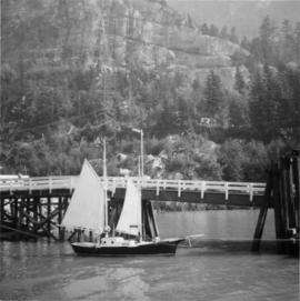
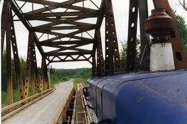
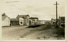
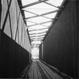
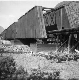
Photograph depicts the Fraser St. road bridge over the north section of the north arm of the Fraser River (ie. between Vancouver and Mitchell Island). Shot is looking northeast.
Photograph depicts the Fraser St. road bridge over the north section of the north arm of the Fraser River, looking north from Mitchell Island to Vancouver, BC
Image depicts the small town of Fraser, B.C. Located on the Klondike Highway.
Handwritten caption above this photo reads: "Fred Youngstrom in [church shirt?]" Photograph depicts two men (Fred on left) standing on snow-covered road in front of car with a British Columbia license plate "93-650". A wood pile and long building with porch can be seen in background in front of forest trees. It is believed that this photo was taken at the camp in Summit Lake, B.C. (see item 2005.3.57).
Handwritten caption beside this photo reads: "Fred Youngstrom & Kitchen Staff. 1946." Photograph depicts Fred standing to right of three woman, a young girl, and a dog. The group is standing on the snow-covered front steps of a (kitchen?) building, lumber pile on far right. A large metal triangle is hanging behind Fred. It is believed that this photograph was taken at the camp at Summit Lake B.C. (see item 2005.3.57).
Handwritten caption beside this photo reads: "Fred Youngstron [sic?]" "Foreman spotting for operator." Photograph depicts one man seated on D8 Caterpillar operating a haulback rig, and a second man (Fred?) standing behind him on Caterpillar. Image quality is poor and faces are not visible. Dirt and debris in foreground, forest in background. It is believed this rig is operating in a long-line skidding system.
Handwritten caption above this photo reads: "Fred Youngstron[sic?]" "Foreman spotting for operator." Photograph depicts one man (Fred?) seated on D8 Caterpillar operating a haulback rig, and a second man standing beside him on the Caterpillar. Dirt and debris in foreground, forest in background. It is believed this rig is operating in a long-line skidding system.
Photograph depicts a freight shed at the Nelson CPR depot. There is a terminal spur on the south side of the shed and road trucks on the north side. The road side of the main depot building can be seen in the left rear of the photo. The view is facing east.
Photograph depicts a freight train at the Pacific Great Eastern yards in Brackendale, as it is about to cross the highway. The view is looking north.
Photograph depicts a westbound freight train near Moyie on the CPR line. This is at about mile 13 on the Nelson Subdivision, which spans 137.8 miles from Cranbrook to Nelson. The line here is adjacent to the Moyie Lake Provincial Campsite. The train is about to enter the portal of a small tunnel that bores through the rocky headland of the lake.
Photograph depicts a Princeton bound freight train passing the old CPR station at Brookmere, located at 30 miles south of Merritt. The freight is passing the summit between Spences Bridge and Princeton. It consisted of 4 locomotives and 38 cars (mainly chip cars). At one time Brookmere was a thriving substation divisional point in the middle of nowhere. Now it is a passing loop to hold 64 cars.
Photograph depicts a southbound freight train passing the old CPR station at Brookmere, located at mile 108.7 on and from the Princeton Subdivision. The freight passed at about 20 mph, after a long grind uphill from Merritt. It consisted of 4 locomotives, 38 cars, and a caboose. Regular freights only pass twice a week, one each on Tuesday and Thursday. It is passing the derelict water tank at the north end of the yards, which are at the summit of this subdivision.
Photograph depicts a freight wagon that stood beside a deserted farm house.
Photograph depicts a freshly painted Canadian National Railway (CN) caboose at Kamloops Junction depot.
Photograph depicts a Gaar Scott traction engine in working order, steamed twice a year at least. It was built by the M. Rumely Co. in Richmond, Indiana, U.S. The engine is a #16541, has 25 horse power, and 2 cylinders. It was photographed at Texaco Station in Nanton, Alberta. It was owned by Jack burrows of Nanton.
Photograph depicts the rear view of the Gaar Scott traction engine parked at Texcoc Station in Nanton, Alberta. The rear wheels have a 2'9" tread. It was used on farms for haulage, threshing, chaff cutting etc., but not plowing.
Photograph depicts a gaff rigged schooner. Its sails were apparently set to dry them. No one was aboard and the vessel was securely moored. Davies notes that it was an unusual sailing rig for the area.
Image depicts a road near or on Gang Ranch in the Upper Fraser Canyon.
Photograph depicts a garbage burner in the Esquimalt & Nanaimo Railway yards in Victoira. This photograph is taken just south of Victoria West Park.
Photograph depicts gas pumps that were adjacent to the Acton Kilby General Store that was operated by Mr. Acton Kilby, aged 81. He is visible in the shadows towards the left of the photograph and the left pump. Mr. Kilby's father acquired the store in 1902. The store was near historical Harrison Mills.
Photograph depicts details of agas tank and carrying handles.
Handwritten photo album caption below this photo reads: "Gathering up the pieces [re. plane crash, item 2006.20.12.42]." Photograph depicts two trucks and a large group of men standing in airstrip believed to be at Whitehorse. Group of various buildings visible in background on right.
Royal Canadian Air ForcePhotograph taken at the Northwood Pulp and Timber Ltd, Prince George. Visible is a General Motors switcher, built in 1959. Aqcuired in 1981. On private Northwood trackage with the mill in the background.
Photograph depicts a switcher running towards a CN interchange. Just left the Fraser River bridge. All private and owned by Northwood Pulp and Timber Ltd.
Photograph depicts young girl standing on front deck of "WANAMAKER'S GENERAL MERCHANDISE." Car visible on left, gas pump in front. Trees and neighbouring house visible in background. Handwritten annotation on recto of photograph: "ATLIN."
Photo depicts a street perspective of George St., in Prince George, BC, ca. 1950. Annotation recto reads: "George St. Prince George BC Photo by J Wrathall." Handwritten annotation in pen on verso of postcard reads: “This is the Hastings Street of Prince George. This & 3rd Streets are the main thoroughfares.”
Photograph of George Street in Prince George B.C. Cars, people, and signage are visible. Printed annotation on recto reads: “George St. Prince George B.C. 1921 R7 by Moore” There is an “X” in ink over the fire hall. Handwritten annotation in ink on verso reads: “This view is also looking north and where I have put the X is the one and only fire hall and you can see the fire engine in the street. This is the main street.”
Handwritten annotation on verso of photograph reads: "George St. Prince George BC Photo. S Wrathall". Prince George Hotel and Cafe stand on left side of street in foreground, and many other buildings and businesses can be seen. Vehicles line the street, cut banks visible in background. Photograph believed to have been taken while George Street was being prepared for a new lawyer of asphalt.
Photograph depicts buildings and vehicles lining street, and hill in background. There is snow on the road and several store signs are visible. Printed annotation on recto reads: “GEORGE ST. PRINCE GEORGE B.C.”
Photograph depicts a wooden arch supporting the sagging Georgia Viaduct in Vancouver, BCThe road in the foreground is Taylor Way.
Image depicts a helicopter in Germansen Landing, B.C.
Image depicts an unknown woman standing in front of a truck that either weighs 80 tonnes, or is capable of carrying that much; the slide is simply labelled "80 tons." It is located at the Gibraltar mine site.
Image depicts the Gibraltar mine site north of Williams Lake, B.C.
Image depicts an 80 tonne truck full of rocks at the Gibraltar mine site north of Williams Lake, B.C.
Image depicts a number of workers putting in blasting powder at the Gibraltar mine site north of Williams Lake, B.C.
Image depicts a loading truck at the Gibraltar mine site north of Williams Lake, B.C.
Image depicts a private driveway, most likely leading to the Ginter Property in Prince George, B.C.
Image depicts a road near the Ginter House in Prince George, B.C.
Photograph depicts a covered wooden grider bridge of the former Great Northern Railway spur that ran from north Washington state into B.C. at Keremeos, then west to Princeton. It was now only operating as far north as Keremeos.
Photograph depicts a covered grider bridge of a former railway (subsidiary of the Great Northern Railway, built in 1907-14) that formerly ran between Keremeos and Princeton, but had long since been lifted. The bridge was now used by vehicles going to a nearby ranch.
Image depicts the CN Station, with bundles of wood sitting near the tracks, in Giscome, B.C. Map coordinates 54°04'32.3"N 122°21'42.3"W
Image depicts the Giscome mill site in Giscome, B.C. The railroad tracks are in the foreground. Map coordinates 54°04'17.6"N 122°22'06.1"W
Image depicts the old CN station in Giscome, B.C. Map coordinates 54°04'20.7"N 122°22'01.1"W
Image depicts the new CN station in Giscome, B.C. Map coordinates 54°04'20.7"N 122°22'01.1"W
Image depicts the old CN station in Giscome, B.C. Map coordinates 54°04'20.7"N 122°22'01.1"W
Image depicts what is possibly the CN Railway Station and tracks located in Giscome, B.C.
Image depicts the Giscome railway station and buildings remaining in townsite in Giscome, B.C. Map coordinates 54°04'18.0"N 122°22'04.7"W
Image depicts a parking lot full of vehicles with the Giscome store in the background. Map coordinates 54°04'18.5"N 122°21'57.7"W
Photograph depicts people on river shore, and boat and buildings in midground. River bank in foreground, forest in background. Handwritten annotation on verso of photograph: "Giscombe Portage Fraser River", on recto: "Huble & Seaback on Fraser River."