Print preview Close

Showing 3593 results

Archival description
Peace River
2012.13.1.91.13 · Item · Oct. 1978
Part of J. Kent Sedgwick fonds

Image depicts the Peace River, possibly near Clayhurst or Hudson's Hope, B.C.

Peace River?
2012.13.1.91.06 · Item · Oct. 1978
Part of J. Kent Sedgwick fonds

Image depicts what is possibly the Peace River running parallel to a road, possibly Highway 29.

Peace River
2012.13.1.93.27 · Item · 1978
Part of J. Kent Sedgwick fonds

Image depicts the Peace River and visible layers of sediment deposits in the surrounding cliffs.

2011.13.53 · Item · 9 August 1911
Part of Parker photograph collection

Side perspective photograph of a Portland Canal Short Line engine being either loaded or unloaded by several men at the station in Stewart, BC. Printed annotation on recto reads: "Aug 9 1911 Stewart BC."

Pat's Pass
2012.13.1.79.18 · Item · Aug. 1977
Part of J. Kent Sedgwick fonds

Image depicts a view of a valley; the slide itself labels the image in two places, "central basin" on the left side of the image, and "Pat's Pass" on the top of the image between the two mountains.

2012.13.1.87.004 · Item · [between 1975 and 1995]
Part of J. Kent Sedgwick fonds

Image depicts several eighteen wheelers at the Pass Lake Road and Upper Fraser Road intersection with numerous houses and buildings in the background in McGregor, B.C. Map coordinates 54°04'38.1"N 121°50'00.1"W

2009.5.2.52 · Item · [ca. 1910?]
Part of Taylor-Baxter Family Photograph Collection

Photograph depicts a man standing in a loaded canoe floating close to shore. Two men stand on rocky shore in left foreground. Tall hills in background, river rapids behind canoe in midground. Handwritten annotation on recto of photograph: "Parle Pas Rapids Peace River."

Parking Lot Frisbee
2012.13.1.93.18 · Item · 1979
Part of J. Kent Sedgwick fonds

Image depicts a group of people throwing a frisbee in a parking lot at an uncertain location, likely in the Peace River Region.

Paddlewheel Park
2012.13.1.7.202 · Item · Nov. 2000
Part of J. Kent Sedgwick fonds

Image depicts the Fraser River at Paddlewheel park, with a train on the other side of the river, in Prince George B.C.

Paddlewheel Park
2012.13.1.7.201 · Item · Nov. 2000
Part of J. Kent Sedgwick fonds

Image depicts the Fraser River at Paddlewheel park, with a train on the other side of the river, in Prince George B.C.

2009.5.4.52 · Item · [ca. 1912]
Part of Taylor-Baxter Family Photograph Collection

Photograph depicts four men on conveyor, and clear view of paddle wheel. A small boat is docked to the conveyor with men and equipment. Crowd of men on shore in foreground on right, trees on opposite shore in background. Mountains visible in distance. Handwritten annotation on verso of photograph reads: "Str. Conveyor".

Packing horses
2014.10.1.010 · Item · 1907
Part of Arthur Holland Land Surveying Collection

Photograph depicts a group of horses in process of being loaded with packs. Four or more men attend. There is a canvas tent, open fire and more people in the background.

2020.08.82 · Item · [between 1915 and 1917]
Part of Pacific Great Eastern Railway Region Photograph Collection

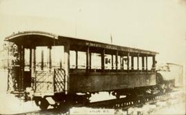
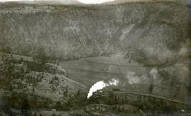
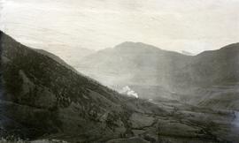
Photograph depicts a Pacific Great Eastern Railway train on Pavilion Creek trestle at Mile 20.3. Also visible are a water tank and possibly the graveyard at Pavilion.

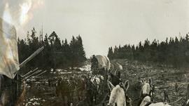
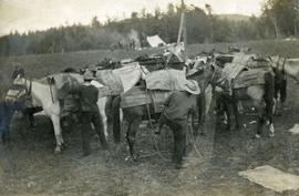
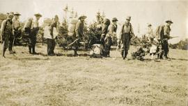
The ca. 1921-1927 “PGE Bridge List” from the notebook of William H. Hewlett (1914-1968) references a 389.4 foot long, 34 ft. high, framed trestle with 26 spans of 14.8 feet at Mile 20.3 carrying the line over Pavilion Creek. There was a water tank at Pavilion located between the North end of the siding and the South end of the trestle. A track profile chart confirms that the track at this point is on a 12 degree curve. This photograph was taken from a vantage point up the hill to the North. The structures at the lower left of this image (2020.08.82) are consistent with a small construction camp, which accounts for the presence of a camp cook in image 2020.08.83.

"Canadian Railway and Marine World" reported in their January 1916 issue (p. 11, c.1), that track had been laid to within ½ mile of Clinton (Mile 45.0) on Dec. 14, 1915. If a constant rate of construction had been maintained from Mile 14, reached on July 30, 1915 as previously discussed, to Clinton, the approximate date of completion to Pavilion would be around the end of August, 1915 which is probably the earliest possible date for this photograph.

Overview of Stewart, BC
2011.13.21 · Item · ca.1910-ca.1930
Part of Parker photograph collection

Photograph of Stewart BC taken from a distance. Trees in the foreground slightly obscure the village, and a large mountain is visible in the background. Printed annotation on recto reads: "Stewart B.C. Hughes 93."