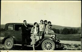
Violet Baxter's older sister Ellen and younger sister Lucy are among other unknown individuals who stand and sit on a car in the road. Ellen stands second from left, and Lucy sits in back behind other girls. Forest and hillside can be seen in background.
Image depicts employee houses on mill site in Giscome, B.C. Tug boats are in the foreground on the right. Map coordinates 54°04'23.4"N 122°22'16.9"W
Image depicts a building surrounded by a tall, circular enclosure somewhere on Haida Gwaii, B.C.
Photograph of a team of sled dogs and resting men silhouetted against snowy mountaintops. Printed annotation on recto reads: "#92 Enroute to Naas On the Big Glacier."
Photograph depicts two men standing and paddling in canoe on river, trees stand above rock face on opposite shore in background. Handwritten photo caption on verso and recto of this photograph reads: "Entering the Grand Canyon."
Photograph depicts the entrance to the Squamish River at Squamish, looking upstream. The pier on the left belongs to the original logging railway, circa 1909-1925.
Image depicts what appears to be an eroding rock face. The slide itself is labelled "ash loger at top" for unknown reasons. Possibly located somewhere near Whitehorse, Y.T.
Image depicts an eroding rock face at an uncertain location.
Image depicts an eroding rock face; the river in the right corner of the image is possibly the Fraser River.
Image depicts Eskers Park, near Prince George, B.C.
Image depicts an atmometer. According to the slide, it is being used for measuring the rate of water evaporation "from carborundum stone." The location is uncertain.
Image depicts a group of individuals who appear to be examining a rock. It is possibly part of an educational trip.
Image depicts three unidentified individuals examining rocks near a set of railway tracks at an uncertain location in the Peace River Region.
Image depicts a view of an experimental farm, possibly taken from Tabor Mountain.
Item is a photograph of the explosion which opened up the diversion route for the Peace River during construction of the W.A.C. Bennett Dam.
Photograph depicts Shannon Falls near Squamish, which was formerly named Fairy Falls.
Image depicts some fallen trees at Island Cache.
Image depicts a farm at an uncertain location.
Image depicts a farm on the west side of the Fraser, south of Quesnel, B.C.
Image depicts what appears to be a farm at an uncertain location.
Image depicts a farm at an uncertain location.
Image depicts a farm at an uncertain location; possibly somewhere in the McGregor Valley.
Image depicts a farm at an unknown location.
Photograph depicts a field in the foreground, trees and mountains in the distance.
Photograph depicts farmstead in cleared area of forest. Plowed and fenced area on left, buildings and firewood on right.
Image depicts an unknown individual standing next to what appears to be a fault at an unknown location.
Image depicts what appears to be a fault at an unknown location.
Image depicts a large number of felled trees, and an unknown individual standing on the path.
Photograph depicts a young female standing beside a stump dressed in outdoor clothing, a tent is in the background.
Photograph depicts a young female standing beside an open tent in outdoor clothing (possibly a crew member?).
Image depicts a fence, perhaps somewhere in the Chilcotin region.
Image depicts a fence in the Blackwater River area in the Chilcotin.
Image depicts a fence somewhere in Anahim Lake, B.C.
Image depicts a fence and power lines near the shore on Haida Gwaii. It is possibly a small community such as Masset.
Image depicts two unidentified individuals standing outside a small, enclosed area somewhere in a forest. The location is uncertain.
Photograph depicts a totem pole standing in front of a forested environment with a fence line in the foreground. Photographer’s stamp on verso: “W.E. Nicholson, 268 E. 10th, Vancouver 10, B.C.”
Photograph depicts a scow loaded with three or more pack horses with men attending. The scow is crossing the river, guided by a cable. There is one building, and forest in the background.
Photograph depicts a man standing near a rough log shed. A fence line leads toward a lake. A small settlement and treed hills in the background.
Image depicts a ferry entering Horseshoe Bay in the Howe Sound region.
Photograph depicts a man standing near a fenced garden plot is nearby. A body of water, a small settlement and treed hills in the background.
Image depicts the Fraser River, likely near the Hansard railroad bridge.
Photograph depicts fields recently cleared from virgin bush on Miracle Breach on Vancouver Island.
Photograph depicts rolling fields with a newly ploughed area in the center of the image with forest in the background.
Photograph depicts a ranch style gate looking beyond to a road and buildings.
Street view photograph of 5th Street. Printed annotation on recto reads: "5th St. Stewart, B.C. Hughes #127."
Image depicts numerous skiers standing near a finish line somewhere on Tabor Mountain in Prince George, B.C.
Photograph depicts river and shore in foreground, hills on opposite shore in background. Handwritten annotation on recto of photograph: "Finlay Forks."