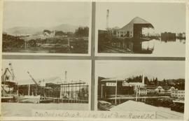
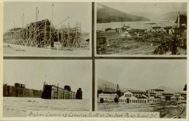
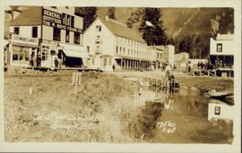
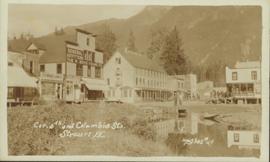
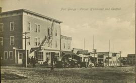
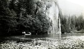
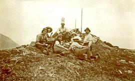
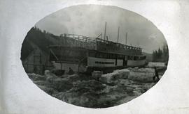
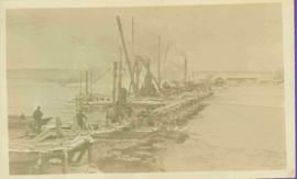
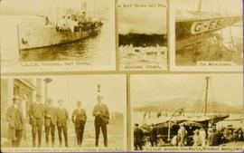
Captions below images on recto read: “H.M.C.S. Thiepval. Capt Beech.; In surf Recks and Fog. Wikelski Island; The Aeroplane; Major Stuart MacLaren, and party, at Prince Rupert. B.C.; British Around –the –World, Wrecked Aeroplane”.
Collection of four photographs of the Prince Rupert dry dock. Printed annotation on recto reads: "Dry Dock and Ship Building Plant, Prince Rupert BC."
Collection of four photographs of the Prince Rupert dry dock. Two images are the finished dry dock buildings. One image is of construction. Printed annotation on recto reads: "Before Launching Canadian Scottish Dry Dock, Prince Rupert BC."
Image depicts a collapsing shack somewhere in the Seton Portage area.
Item is a hand drawn and coloured map by the City of Prince George Planning Department depicting the College Heights and southwest (Vanway) neighbourhood area existing land use in 1976.
Group can be seen in distance by canoe close to trees and cliff on opposite shore. Rocky shore of river in foreground.
Handwritten annotation on verso reads: " 'The Place of Echoes' The Big Creek at Kincolith. Dad, Jack, Joyce & Bob Stewart". Believed to be present in image are the son, grandson, and granddaughter of Archdeacon W.H. Collison, respectively: Rev. W.E. Collison, John (Jack) Macdonald and Joyce Collison.
Photograph depicts the sons and daughters of Marion and Archdeacon W.H. Collison sitting on the ground with food supplies at the top of a hill. Individuals believed to be (left to right): Arthur, Elsie, Herbert, Henry (in chef's hat), unknown, William, John Maxwell ('Max').
Handwritten annotation on verso reads: "Collison family on prospecting trip up Portland Canal."
Photograph depicts the sons and daughters of Marion and Archdeacon W.H. Collison, and one unidentified man. Buildings can be seen on shore in background.
Handwritten annotation on verso reads: "Collison family at camp (Portland Canal) Max, ?, Henry, Elsie, Arthur, Alice, Herbert".
Photograph of a bridge along a rocky shoreline. Printed annotation reads: "Colloway Rapids Bridge Prince Rupert Highway W.W.W." Handwritten annotation on verso is heavily obscured by residual album paper and reads: "PO Box 777 Prince Rupert BC. [Illegible] Lal. This[??] is a piece of our new bridge which [obscured] neats our Island with the mainland. We have had picnics on the other side & [illegible] is open for [illegible] to [illegible]ve ours this side of the [obscured] our stuff to the little [obscured] patronize[??]. Mrs. [illegible] are back again in Rupert [obscured] Kamloops office closed down [obscured] was no chance of transfer. Have not."
Street view photograph of several commercial buildings on an unidentified dirt road in Prince Rupert, BC. Foreground is primarily a shot of "Wallace's Dry Goods."
Photograph depicts a Chevrolet pickup truck on highway to right of Mud Lake, at Km 632 on the Stewart-Cassiar Highway. Forest on hillside in background.
Photograph depicts an unidentified man walking in front of orange and brown two-story building speculated to be bunkhouse residences. Second unknown individual can be seen unloading car in left foreground. Trees and mountains visible in background.
Photograph depicts four orange and brown two-story buildings speculated to be bunkhouse residences. Blue car in foreground, forest and mountains in background.
Photograph depicts two unidentified individuals in canoe on Boya Lake, B.C. (formerly known as Chain Lakes). Foliage silhouetted in foreground; forest and hills on opposite shore in background.
Photograph depicts church believed to be the All Saints Anglican Community Church at Cassiar, B.C. Trees and fence in foreground, forest and mountain in background.
Photograph depicts two fire trucks semi-visible in garage with the sign "FIRE HALL". House and snowmobile can be seen in left midground, truck and power pole in right foreground. Mountains in background. Warning visible on front of trucks: "KEEP BACK 500m".
Photograph depicts group of men and women on rocky shore, pile of fish in foreground. Photo speculated to have been taken in the Telegraph Creek area, possibly at the Tahltan or Stikine River, B.C.
Photograph depicts row of houses on either side of street in midground. Forest trees in foreground, mountains in background.
Photograph depicts the new mine garage behind machinery, mountains in background. Mobile blast hole drill can be seen in left foreground (manufactured by Robbins with Caterpillar undercarriage). Two 50-tonne Wabco "haul paks" in right foreground (ore haulage trucks).
Photograph depicts two-story main office building in right midground behind sign reading "CASSIAR ASBESTOS CORPORATION Ltd / CASSIAR MINE / MAIN OFFICE". Building believed to be warehouse can be seen behind raised Canadian flag on pole in left midground. New mill building and tailings pile visible behind warehouse and office, mountains in background.
Photograph depicts two unidentified men playing tennis in foreground. Buildings stand in midground, including what appears to be the All Saints Anglican Community Church. Forest and mountain in background.
Photograph depicts unidentified man walking up front steps to building with the following sign: "TOWN ADMINISTRATION / MOTOR VEHICLE BRANCH / HCBC AGENCY / DISTRICT REGISTRAR / CDN CITIZENSHIP COURT / FISH & GAME LICENCES". Vehicles parked in foreground and behind at unknown building in midground. Power line and mountains in background.
Photograph depicts ore cars on cables running between tramline towers. Flowers in foreground, mine valley and McDame mountain in background. Tramline ran through mine valley, between loading station (2000.1.13.19.197) in mine and dump station at mill on plantsite (2000.1.1.3.19.124)
Photograph depicts a group of children dressed in white walking in a line, and adults and other children watching from behind. Group of six man stand in line on left, one holding a flag, another a drum. Jail tower and large building stand behind fence in background.
Handwritten annotation on verso reads: "Old Mission House & jail at Metlakatla Before the fire."
Image depicts what appears to be a small community on the shore of a lake. The location is uncertain.
Image depicts several unidentified concrete structures that are badly damaged and cracking, located on old mill site in Giscome, B.C. Map coordinates 54°04'18.0"N 122°22'04.7"W
Image depicts a construction area somewhere in Tumbler Ridge, B.C.
Photograph depicts construction of a possible steamboat at Soda Creek.
Photograph depicts a large construction in Victoria BC, possibly be related to the construction of the Johnson Street Bridge or the construction of a large building near the shoreline.
Item is a photograph of the construction of a temporary river bed to divert the Peace River during construction of the W.A.C. Bennett Dam.
Photograph depicts pier under construction, workers, buildings smokestacks and river with chunks of ice. Handwritten annotation in pencil on recto reads: “S. FT. GEORGE G.T.P. BRIDGE”.
Item is a photograph of the construction of the WAC Bennett Dam.
Item is a photograph of the construction of the W.A.C. Bennett Dam
Slightly elevated street view of buildings and sidewalks being constructed in Prince Rupert, BC. Printed annotation on recto reads: "Photo by McRae Bros. Third Ave Prince Rupert, BC." Handwritten annotation on verso reads: "Dear Florence you better [illegible] will try and answer it in a few day I am well I will try and send you some cards I will stay here till in Dec Write[??] me and send me some cards I am 15 mile in the mountains Write your Bro LS Bill." Postcard is addressed to: "Miss Florence Wilson P.O. Box 1178 Worcester Mass U.S.A." A 2 cent Canadian stamp is affixed on verso. Postmark reads: "Prince Rupert BC Jul 1 10."
Photograph depicts yellow conveyor belt in foreground over gravel pit, dump truck behind in midground. Mountains visible in background. Photo speculated to have been taken at the plant or near the Cassiar airstrip. Stamped annotation on recto of photograph: "JUN. 1987".
Photograph depicts men standing on upper deck of conveyor, close to opposite shore, where lumber and buildings can be seen. Canoe in left foreground, trees and mountains in background.
Photograph depicts five men sitting on a rough, log table. Table is under a tarp, upturned pails and cooking utensils are on the table.
Photograph depicts a rough table under a canvas tarp. There are various cooking utensils on the table and hanging from the tarp support. A man stands behind the table.
Image depicts a cookhouse at an uncertain location.
Image depicts a cookhouse at Sinclair Mills, B.C.
Photograph taken from a low elevation of various businesses in Stewart, BC. Visible businesses include "The R. Boyd Young Co." and "Motel King Edward." Printed annotation on recto reads: "Cor. 5th and Columbia Sts. Stewart. B.C. Hughes #45."
Photograph taken from a low elevation of various businesses in Stewart, BC. Visible businesses include "The R. Boyd Young Co." and "Motel King Edward." Printed annotation on recto reads: "Cor. 5th and Columbia Sts. Stewart. B.C. Hughes #44."
Street view of some vehicles parked in front of commercial buildings in Prince/Fort George. Businesses include "J.P. Robertson 'The Men's Store'" and "James & Co. Clothing and Shoes." Printed annotation on recto reads: "Fort George- Corner Hammond and Central."
Photograph depicts a street scent at the corner of Laselle and Second St. in Fort George. A wagon is visible in the dirt road and wooden buildings cross the mid ground. Three unidentified men sit on the boardwalk outside Rigg's Restaurant while one man stands in the doorway of The White Laundry.
Image depicts a rail road bridge, possibly the Cottonwood Bridge, at an uncertain location.
Image depicts the Cottonwood Bridge.