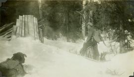
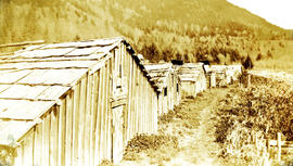
Photograph depicts a row of small buildings constructed of lumber. These deserted buildings may be located in or near the Red Bluff Indian Reserve 88 of the Nisga'a People. Handwritten annotation below photograph reads, "Indian village of Red Bluff, deserted".
Photographed depicts part of a deserted roundhouse in the CPR Penticton yard. It is a 5 bay house, which all lead to the turntable that is still in use. The view is looking northeast.
Photograph depicts a deserted wharf and the Esquimalt & Nanaimo Railway, located in the foreground. It had its trackage and ties removed recently. Davies believed it to be a private wharf and railway for the Hartsville Coal Mine that operated in 1920-1941.
Photograph depicts an abandoned 3-track wharf leading to a north running connection with the Esquimalt & Nanaimo Railway. It connected on mile 85. The trackage beyond the wharf had recently been remove while the wharf itself had not been evidently been used for many years.
Photograph depicts an abandoned wharf with rail trackage that formerly led to the Esquimalt & Nanaimo Railway.
Caption: "Deserter Canyon"
Photograph depicts the design for the coin commemorating the 1978 XI Commonwealth Games in Edmonton Alberta. Design details both sides of the coin.
Photograph depicts two pick hammers laid in asbestos fibre. Annotations on note glued to recto of photograph: "ASBESTOS"; "Detail view of asbestos talus. Early test pit near top of showing. Western slope." Areas of image have been labeled "A" and "B". Photo caption under printed copy of image in 1952 Annual Report: "A - Asbestos fibre partially opened by frost action. B - Serpentine rock originally containing the asbestos fibre."
Photograph depicts a spare crane and an idler car.
Photograph depicts a spare crane and an idler car. Visible are the details of the rear end of the idle car.
Photograph depicts details of a CN derailment that occurred in Kamloops.
Photograph depicts the details of 3 axle trucks and car steps.
Photograph depicts details of a spout on a preserved water tank.
Photograph depicts stalks of devil club. Handwritten annotation below photograph reads, "devil club stalks".
Map of Timber Sale X72108 shows area to be scarified. Location is outside Prince George in the Upper Fraser area near Kenneth Creek.
Map of Timber Sale X72108 shows area to be scarified, as well as previously logged areas. Location is outside Prince George in the Upper Fraser area near Kenneth Creek.
Image depicts an aerial view of Diamond Island, near Quesnel, B.C.
Caption: Dick, Shorty Haynes (6'4"). Trappers' lean-to, McGregor River, tributary to the Fraser [River]. Item is a photograph of "Shorty" Haynes in snow shoes and carrying a pack sack looking at a trappers' lean-to while pack dog "Dick" looks on.
Item is a photograph of Skookum Davidson holding Dick by the collar in an open field.
Item is a photograph of three husky pack dogs resting in the snow.
Item is a photograph of Skookum Davidson and Walter hunting in the grass with two pack dogs.
Photograph depicts a former steam roller that was converted to diesel drive. It was no longer working.
Item is a photograph of a copy print that has been reproduced as a slide, resulting in low photographic quality. Location of original photograph unknown.
Photograph depicts a diesel switching locomotive, owned and on the premise of the Vancouver Iron and Engineering Works Ltd, at 1155 west 15th Ave. The view is looking north to False Creek.
Image depicts a dilapidated house in Sinclair Mills, B.C.
Image depicts two dilapidated houses in Sinclair Mills, B.C.
Image depicts an old house for sale surrounded by overgrown bushes in Upper Fraser, B.C. Map coordinates 54°07'15.0"N 121°57'02.0"W
Photograph depicts a small vessel called "Dinamac." It had a red hull, suggesting that it may have been a Department of Transport tender.
Image depicts an old building with a sign labelling it as a "Dining Lounge," it is possibly in Prince Rupert, B.C.
Item is a photograph of dinosaur footprints discovered at the W.A.C. Bennett Dam site.
Photograph depicts group of nine men standing on lawn in front of building known as "House 130" or "Director's Lodge". Left to right: Andre Beguin, unknown, Charles Rainforth Elliot, Jack Christian, W. Harold Connell, Plato Malezemoff (from Newmont Mining), Tam Zimmermann, Ken A. Creery, Fred Martin Connell. Daffodils and tulips planted in foreground, trees and mountains in background. Most men featured in photo are believed to be members of Cassiar's Board of Directors; Beguin was a General Superintendent.
Photograph depicts group of eight men standing on lawn in front of building known as "House 130" or "Director's Lodge" (see item 2000.1.1.3.19.88). Left to right: Nick Gritzuk, Charles Rainforth Elliot, Jack Christian, W. Harold Connell, Plato Malezemoff (from Newmont Mining), Tam Zimmermann, Ken A. Creery, Fred Martin Connell. Daffodils and tulips planted in foreground, trees and mountains in background. Most men featured in photo are believed to be members of Cassiar's Board of Directors.
Photograph depicts group of eight men standing on lawn in front of building known as "House 130" or "Director's Lodge". Left to right: Nick Gritzuk, Charles Rainforth Elliot, Jack Christian, W. Harold Connell, Plato Malezemoff (from Newmont Mining), Tam Zimmermann, Ken A. Creery, Fred Martin Connell. Elliot appears to be comparing height with Gritzuk. Trees and mountains in background. Most men featured in photo are believed to be members of Cassiar's Board of Directors.