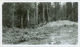
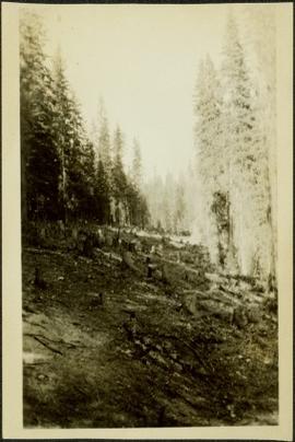
Showing 27993 results

Archival description
17269 results with digital objects Show results with digital objects
2006.18.6.01 · File · [196-?]
Part of Aleza Lake Research Forest Society fonds

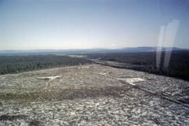
Photographs are panoramas taken from the Churchill BC Forest Service Lookout, located at latitude 54°04' and longitude 122°16'. The photographs were bound together and include a transparent grid that was intended to be used for locating forest fires.

Chute depot on the CPR line
2013.6.36.1.024.11 · Item · [24 June 1979]
Part of David Davies Railway Collection

Photograph depicts the Chute depot at mile 106.5 on the CPR line in the Carmi Subdivision. It is a totally isolated location, but not reachable by road. The photo shows the only surviving large building. The rail here is dated 1942.

"City Hall"
2012.13.3.1.15.02 · Item · Aug. 2002
Part of J. Kent Sedgwick fonds

The item is a photograph of a photograph depicting Prince George's City Hall circa. 1922 including an approximately 120 word write up describing its history. The building is approximately two stories high. There is an artillery cannon next to the building. A reflection of the photographer is barely visible in the photograph.

"City Hall"
2012.13.3.1.15.03 · Item · Aug. 2002
Part of J. Kent Sedgwick fonds

The item is a photograph of a photograph depicting Prince George's City Hall circa. 1922 including an approximately 120 word write up describing its history. The building is approximately two stories high. There is an artillery cannon next to the building. A reflection of the photographer is barely visible in the photograph.

"City Hall"
2012.13.3.1.15.04 · Item · Aug. 2002
Part of J. Kent Sedgwick fonds

The item is a photograph of a photograph depicting Prince George's City Hall circa. 1922 including an approximately 120 word write up describing its history. The building is approximately two stories high. There is an artillery cannon next to the building. A reflection of the photographer is barely visible in the photograph.

City Hall
2012.13.1.3.165 · Item · May 2001
Part of J. Kent Sedgwick fonds

Image depicts Prince George City Hall. Map coordinates 53°54'46.3"N 122°44'41.9"W

"City Hall"
2012.13.3.1.15.07 · Item · Aug. 2002
Part of J. Kent Sedgwick fonds

The item is a photograph of a photograph depicting Prince George's City Hall circa. 1922 including an approximately 120 word write up describing its history. The building is approximately two stories high. There is an artillery cannon next to the building. A reflection of the photographer is barely visible in the photograph.

"City Hall"
2012.13.3.1.15.05 · Item · Aug. 2002
Part of J. Kent Sedgwick fonds

The item is a photograph of a photograph depicting Prince George's City Hall circa. 1922 including an approximately 120 word write up describing its history. The building is approximately two stories high. There is an artillery cannon next to the building. A reflection of the photographer is barely visible in the photograph.

"City Hall"
2012.13.3.1.15.06 · Item · Aug. 2002
Part of J. Kent Sedgwick fonds

The item is a photograph of a photograph depicting Prince George's City Hall circa. 1922 including an approximately 120 word write up describing its history. The building is approximately two stories high. There is an artillery cannon next to the building. A reflection of the photographer is barely visible in the photograph.

"City of Prince George"
2012.13.2.15.18.27 · Item · 2001
Part of J. Kent Sedgwick fonds

The photograph of the map depicts a map of Prince George, BC with the location of eleven buildings as points of interest and the years they were built. Areas covered on the map are South of the Nechako River, East of the Fraser River, North of Bowser Street, and West of Fraser Street. All street names are written on their specific roads.

"City of Prince George"
2012.13.2.15.18.28 · Item · 2001
Part of J. Kent Sedgwick fonds

The photograph of the map depicts a map of Prince George, BC with the location of eleven buildings as points of interest and the years they were built. Areas covered on the map are South of the Nechako River, East of the Fraser River, North of Bowser Street, and West of Fraser Street. All street names are written on their specific roads.

City of Prince Rupert
2009.10.3.66 · Item · [between 1923 and 1926]
Part of Fred Jeffery Photograph Collection

Photograph depicts a view of a walkway and slew, power poles, city buildings and mountains in the background. Handwritten annotation below photograph reads, "Portion of Rupert".

2012.13.3.1.16.1 · Item · Jan. 1998
Part of J. Kent Sedgwick fonds

The item is a photograph depicting the Prince George Coliseum from the outside. It shows a full parkin lot, a bus dropping people off and a layer of snow on the ground. The Civic Centre can be seen in the background. The annotation on the back states, "Coliseum Jan. 98."

Clanston road
2012.13.2.15.31.01 · Item · [between 2001 and 2010]
Part of J. Kent Sedgwick fonds

The item is a photograph depicting a metal swinging gate and cattleguard on Clanston Road. Annotation on reverse side of photograph states, "Clanston Rd."

Clanston road
2012.13.2.15.31.02 · Item · [between 2001 and 2010]
Part of J. Kent Sedgwick fonds

The item is a photograph depicting Clanston Road. Annotation on reverse side of photograph states, "Clanston Rd."

Classroom Photograph
2008.3.1.102.1 · Item · [1995 or 1996]
Part of Bridget Moran fonds

Photograph depicts group of unidentified men and women seated in chairs in unknown classroom.

2009.10.1.96 · Item · [between 1926 and 1933]
Part of Fred Jeffery Photograph Collection

Photograph depicts several persons standing watching a man with a shovel. The charred remains of a building are being cleaned up. Handwritten annotation below photograph reads, "cleaning up after fire, Echo Cove".

Clear Cut Logging
2012.13.1.122.03 · Item · Oct. 1975
Part of J. Kent Sedgwick fonds

Image depicts a highway, and a section of mountain in the background which is bare due to clear-cut logging. It is possibly somewhere near Prince George, B.C.

Clear Cut Logging
2012.13.1.122.04 · Item · Oct. 1975
Part of J. Kent Sedgwick fonds

Image depicts a logging area, and a section of mountain in the background which is bare due to clear-cut logging. The slide is also labelled "logging show." It is possibly somewhere near Prince George, B.C.