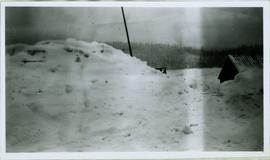
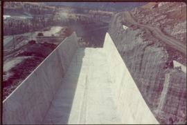
Photograph depicts very large snow pile in plowed yard. A small building with a log roof is semi-visible behind snow on far right.
Image depicts the Buckhorn Snowmobile Club, though it was formerly the Buckhorn school.
Image depicts the annex for the Buckhorn Snowmobile club.
Image depicts a snow-covered road with vehicle tracks, and several houses. The location is uncertain.
Image depicts a bridge at Soda Creek, B.C. There are numerous unknown individuals present.
File consists of photographs depicting Soda Creek Cemetery and presumably the general Soda Creek area. Also includes photographs of a personal residence and Kent Sedgwick with a dog.
Image depicts the old BX Sternwheeler office building in Soda Creek, B.C.
Image depicts the cemetery in Soda Creek, B.C.
Image depicts a house in Soda Creek, B.C.
Image depicts the old community hall in Soda Creek, B.C.
Image depicts the old jail house in Soda Creek, B.C.
Image depicts an old building located somewhere are the Pickard farm north of Soda Creek, B.C.
Image depicts what appears to be a Ranch at Soda Creek, B.C.
Image depicts a section of land, with a few houses, in Soda Creek, B.C.
File consists of notes, clippings, and reproductions relating to South Fort George. Includes: "South Fort George - A trip to the past" heritage brochure produced by South Fort George Community Association (1987) and "B.C. Express Co. Heritage Site" typed document prepared by the Heritage Advisory Committee (Feb. 1994). Also includes photographs depicting various buildings from old South Fort George.
Image depicts a house somewhere in the South Fort George subdivision of Prince George, B.C.
Overhead view of downtown Prince George with a forested area in the background. Printed annotation on recto reads: "South Fort George- 1914."
Photograph depicts the Cassiar valley: plant and tailings pile in left foreground, west end of town in right foreground. South mountain range stands in background.
Image depicts Southbank, B.C.
Image depicts the interior of the ferry at Southbank, B.C.
The item is a photograph of Speedy Cash and Gundy's News building on 3rd Avenue in Prince George.
Item is a photograph of the concrete spillway.
Image depicts a few houses, most likely near the airport in Prince George, B.C.
Image depicts a rural setting, most likely near the airport in Prince George, B.C.
Image depicts an old building at an uncertain location. The slide is simply labelled "Spring house."
Image depicts a Lakewood view of Spruceland in Prince George, B.C.
The item is a front exterior photograph of Spruceland Elementary School at 3805 Rainbow Drive, Prince George.
Hand coloured photo of various squatter's shacks and tents, with mountains in the background. Printed annotation on recto reads: "Squatters, Prince Rupert, B.C." Artist's stamp on lower right corner reads: "104,0033 J.V."
Church stands behind white fence, road and power lines in foreground.
Handwritten annotation on verso reads: "St. Andrew's Church, Sandwick, [?] Campbell River Rd (Maud Highway) The mother church in the '[?] District'."
Photograph depicts St. Anne's log church on French Creek, near Parksville on Vancouver Island. The church was built in 1894 and was still in use at the time.
Photograph depicts St. Ann's Academy, a girls boarding school. In the distance, a graceful spire marks the highest point of the building.
Photograph depicts St. Ann's Academy, a girls boarding school that was close to the centre of Victoria. In the corner of the property, nuns had established the first school in B.C. in 1853.
Photograph depicts St. Ann's Academy, a girls boarding school that was close to the centre of Victoria. Captured the front of the main building.
Side perspective of St. Frederick’s Catholic Church located on Brown Ave. in Giscome. Handwritten annotation in pen on verso reads: “The Catholic Church, St. Frederick.”
Photograph depicts the St. Helen's Anglican Church on Old Yale Rd. (overlooking the Patullo Bridge) in South Westminster, Surrey.
Photograph depicts St. Hilda's Anglican Church in Sechelt on the Sechelt Peninsula. Tall tree on left just coming into flower is a dogwood.
Photograph depicts St. John the Divine church, built in 1914 at Hubert which is now a ghost town. Moved to this location in the open country in 1928.
Image depicts the St. Joseph's Roman Catholic Church, in Kamloops, B.C.
Image depicts a large crowd of people seated inside the St. Joseph's Roman Catholic Church in Kamloops, B.C.
Image depicts the altar inside the St. Joseph's Roman Catholic Church in Kamloops, B.C.
Image depicts a representation of the crucified Christ in the St. Joseph's Roman Catholic Church in Kamloops, B.C.
Photograph depicts St. Margaret's Anglican Church on Bradner Rd., 3 miles northeast of Aldergrove in the Fraser Valley.
File contains slides depicting St. Marie, Ontario.
Image depicts St. Mark's Anglican Church in Woodpecker, B.C.
Image depicts the St. Mark's Anglican Church and a small house in Woodpecker, B.C.