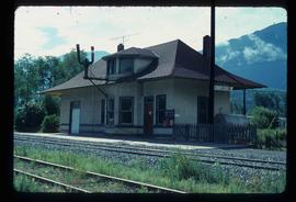
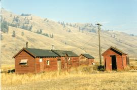
Postcard depicts Kamloops station at about 1895.
Image depicts the townsite of Keithley Creek, B.C.
Image depicts a blue truck and a camper in the wooded area surrounding the townsite of Keithley Creek, B.C.
Photograph taken at the Kekuli Bay Provincial Park and boat launch. Image captures the view of all 25 speeders on an Okanagan tour of "Motor Car Operators West" (a U.S. group with western Canadian additions). On this segment, Davies travelled in the fifth speeder from the front.
Photograph taken at the Kekuli Bay Provincial Park and boat launch. On the speeder meet, there was always a semi-official photograph of the whole group and this was the selected spot. Here, no power boats could take the see-saw.
Photograph taken on the Kelowna "main" line, which was perhaps half of a mile south of the Lumby Junction on the very outskirts of Vernon.
Image depicts a boat on the Nechako Reservoir at Kenny Dam.
Image depicts a boat dock on the Nechako Reservoir at Kenny Dam.
Photograph depicts ore haul truck at dump in mine, driver visible, mountain range in background. Handwritten annotation on recto of photograph: "Kenworth - Model 802 dumping stripping waste at 6565 Elevation", on verso: "1961".
Photograph taken at Kettle River Bridge. Immediately on the far side of the river, the track did a sharp turn to the side of Christina Lake.
Photograph taken at the Kettle River Bridge on the former Boundary Subdivision about 12 miles due east of Grand Forks. Visible is a deck truss and dock plate girder spans that were believed to have originally a covered bridge.
Image depicts a woman walking along the trail of the Kettle Valley Rail Road.
Image depicts the trail of the old Kettle Valley Rail Road.
Image depicts a man standing on the old Kettle Valley Rail Road.
Image depicts the old Kettle Valley Rail Road.
Image depicts several unknown individuals standing on the old Kettle Valley Rail Road.
Image depicts the Okanagan Kettle Valley, with the Kettle Rail Road faintly visible among the trees
Image depicts the trail of the old Kettle Valley Rail Road.
Image depicts a woman standing on the old Kettle Valley Rail Road.
Image depicts a view of Kettle Valley, with a bridge of the old Kettle Valley Rail Road visible on a slope.
File consists of documentary photographs taken by David Davies of Kettle Valley Railway equipment found in Brookmere, British Columbia.
File consists of documentary photographs taken by David Davies of the Kettle Valley Railway line from Merritt to Midway, British Columbia.
Photograph depicts a locomotive belonging to the Kettle Valley Railway Heritage Society in Summerland.
Photograph taken at the temporary upper terminus at the Prairie Valley station (near the Rodeo Grounds). The tourist train originally started with 4 kilometers of track, but in September 1996, it increased to 10 kilometers by continuing past Summerland to the Rodeo Grounds. Turn-around siding was also installed beyond the new terminus. The first train went over the new track on August 22, 1996. Summerland was down grade to the right of the photo.
Photograph depicts a shay rounding around its train at the temporary south terminus at Canyon View Road Crossing, 200 yards from Trout Creek Bridge.
Photograph taken from a grade crossing that went into the Rodeo Grounds in Summerland. Locomotive belonged to the Kettle Valley Railway Heritage Society.
Photograph depicts a home built open car of the Kettle Valley Steam Railway.
Image depicts a woman walking along a trail somewhere in Kettle Valley, B.C.
Image depicts a van on a narrow road, likely the Kettle Valley Trail.
Postcard depicts Kicking Horse Canyon.
Postcard depicts the Kicking Horse Canyon. As seen from the Golden-Field Highway. Along the CPR line.
Postcard depicts Kicking Horse Canyon in the Canadian Rockies.
Postcard depicts Kicking Horse Canyon, Field, BC on the CPR line.
Postcard depicts Kicking Horse Canyon, Field, A.B.. on the CPR line.
Postcard depicts Kicking Horse Pass, Golden B.C.
Image depicts numerous docked boats, as well as many houses on the shore in the background; located in Kitimat, B.C.
Image depicts numerous docked boats in Kitimat, B.C.
Image depicts a harbour in Kitimat, B.C.
Image depicts the CN Rail station located in Kitwanga, B.C.
Photograph depicts Knox McCusker’s pack train traversing across an unidentified mountain ridge, ca. 1930. Caption on verso reads: “Knox McCusker’s pack train, ‘30’s”.
Photograph depicts Koksilah depot of the Esquimalt and Nanaimo Railway on Vancouver Island. It is 2 miles south of Duncan and the view is looking north.
Photograph depicts the Kelowna Pacific Ralway yard in Vernon, near the CNR Okanagan Subdivision.
File consists of documentary photographs taken by David Davies of Kettle Valley Railway and current Burlington Northern Railroad trackage in Grand Forks and Greenwood, British Columbia.
Photograph depicts KVR (CPR) trackage between Boundary Falls and Midway. The line had not yet been officially abandoned, but it was little used, if not at all.
Photograph depicts a terminus of a boundary Subdivision on mile 126.6 from Nelson.
File consists of documentary photographs taken by David Davies of the dismantling of the KVR line from Princeton to Jura, British Columbia.