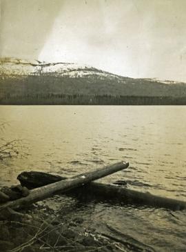
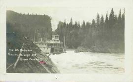
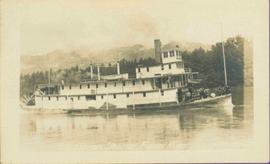
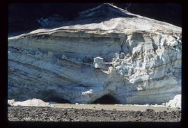
Showing 3808 results

Archival description
3546 results with digital objects Show results with digital objects
Avenue A in Prince Rupert
2011.3.3.75 · Item · 9 August 1908
Part of North Coast & Central BC Postcard Collection

Slightly elevated view of the Prince Rupert Inn on Avenue A. Printed annotation on recto reads: "Avenue A Prince Rupert BC Allen Photo." Handwritten annotation on verso reads: "August 9 1908 Hopping[sic] this will find you all well with kind regards. [illegible]. C Mouat." Postcard is addressed to: "Miss Jemima Colvin Rosedale Farm Cowichan Station B.C." Verso affixed with a one cent Canadian stamp. Postmark on verso reads: "Prince Rupert BC Au 9 08."

Babcock Creek
2012.13.1.55.27 · Item · 1971
Part of J. Kent Sedgwick fonds

Image depicts two unknown individuals pulling a canoe through Babcock Lake's three mile creek.

Back Road
2012.13.1.41.11 · Item · 2002
Part of J. Kent Sedgwick fonds

Image depicts a back road at an uncertain location, possibly near Iron Road North, north of Woodpecker, B.C.

Bare Logs
2012.13.1.122.17 · Item · [1979?]
Part of J. Kent Sedgwick fonds

Image depicts numerous logs that have been stripped of their bark at a saw mill in Prince George, B.C.

Bare Trees
2012.13.1.93.35 · Item · 1978
Part of J. Kent Sedgwick fonds

Image depicts a forest of bare trees, possibly somewhere near Fort St. John, B.C.

2000.1.1.2.2.29 · Item · 1963
Part of Cassiar Asbestos Corporation Ltd. fonds

Handwritten caption beside this photo reads: "Elaborate barricades required due to amount of loose rock falling continuously". Three men work in area confined by barricades made of vertical metal rods and horizontal wood planks. Miscellaneous building material and supplies cover the ground. Rock pile in foreground on right.

Barriere
2012.13.1.74.01 · Item · Aug. 1974
Part of J. Kent Sedgwick fonds

Image depicts a section of river located somewhere near Barriere, B.C.

Battle Hill
2012.13.1.51.108 · Item · 1978
Part of J. Kent Sedgwick fonds

Image depicts the Battle Hill National Historic Site in Kitwanga, B.C.. The sign located there says: "The small knoll in the valley was a native fortress. Legends maintain that it was man-made: built to repel marauding coastal tribes. The hill was the scene of local tribal battles, and at one time was crowned with the defenders' buildings. Known as Dhawdezp, the unique mound is a prominent feature in the legends and history of the Indian people."

2012.13.2.19 · Subseries · 1955-2011
Part of J. Kent Sedgwick fonds

Subseries contains material collected and created by Kent Sedgwick for research on various areas in British Columbia and Alberta. Includes written notes by Kent Sedgwick, pamphlets, and newspaper clippings relating to towns and settlements. These areas include Quesnel, Likely, the Yukon Telegraph Trail, Barkerville, Wells, the Cariboo region, Fort Alexandria, Soda Creek, the Chilcotin region, Jasper, the Rocky Mountains, Mackenzie, Tumbler Ridge, the Peace River region, Fort St. James, the Omineca region, Kitimat, Lethbridge, the Bulkley Valley, and Fort Mcleod. These files cover a variety of topics including Chinese people in British Columbia, land settlement, tourism, and historic information on the regions.

2012.13.2.17.08 · File · 2003
Part of J. Kent Sedgwick fonds

File consists of notes and reproductions relating to the Upper Fraser historical geography field trip for the BC Historical Federation by Kent Sedgwick. Includes photographs depicting a group from the BC Historical Federation standing outside at one of the East Line communities listening to a presentation by Kent Sedgwick and Greg Halseth (May 2003).