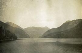
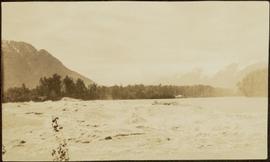
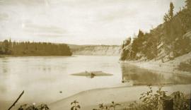
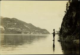
Typed annotation on recto: "Stuart Lake Scene - British Columbia." Man stands in water close to cliff which is reflected in water on right. Hills on opposite shore can be seen in background.
Photograph depicts a man bathing himself while standing in a small metal tub. Photograph description in album notes this as "His 'Semi Annual'" [bath]. On the left is a log structure, presumably a cache building. A large clearing surrounds the building and bathing man. There is a forest and bluff in the background. Possibly located near Giscome Portage.
Image depicts a man, possibly Kent Sedgwick, standing next to a monument which states: "In honour of the pioneers of the Ootsa Lake Valley, first settled in 1905." Located somewhere in either the Francois Lake Provincial Park or the Wistaria Provincial Park.
Image depicts a man, with what is possibly the Robson Glacier visible in the background.
Photograph depicts the Mamquam River near Squamish.
Photographs depict different construction projects at separate locations in Cassiar. Photographs were originally housed in envelopes with the following annotations: "POLICE STATION. July 15, 1977."; "Aggregates and Concrete (PERMASTEEL)"; "Fibre Storage and Handling"; "Powerhouse Expansion"; "Sewage Collection Plant."; "Sewage Treatment Plant"; "Single Person Accommodations - Site Work."; "Outside Work - Camp Nos. 1,2,3." Photos generally feature the work sites, supplies, vehicles, machinery, and work in progress at each location.
Additional photographs integrated into file include maintenance project on lining of tubes, lining of aspiration hood, and lining of willow fiberizer. Also five photographs of maintenance in the townsite to fix in ground piping.
Photograph depicts a view of main street Grand Forks BC.
Photograph depicts a view of main street Grand Forks, BC. There are power poles in the center of the photograph, buildings line the street
Photograph depicts a view of main street Grand Forks, BC.
Photograph depicts a billboard size sign on the side of a building in Grand Forks BC.
Photograph depicts a view of main street Grand Forks, BC.
Photograph depicts a group of men standing near a building with the sign, "James Reid Ltd. General Merchants". There are a few fences and buildings in the background.
Hand coloured photo of Main Street in Prince Rupert, with various tents and buildings on either side of the wooden road. Printed annotation on recto reads: "Main Street, Prince Rupert, B.C. : On comparatively Level Line London to Yokohama." Artist's mark on lower right corner reads: "104,035 J.V."
Photograph depicts the main street of Rolla with a dirt street and wooden sidewalks, tethered horses, and the storefront of H.G. Atkinson General Merchants. Three people are visible walking through the streets.
Image depicts several buildings along the main street in Stewart, B.C. One of them has been boarded up.
Image depicts several buildings along the main street in Stewart, B.C.
Image depicts the main street of Stewart, B.C.
File contains slides depicting places in and around Mackenzie Town.
Image depicts the Mackenzie Reservoir in Mackenzie, B.C.
Image depicts numerous vehicles in the parking lot of a mall in Mackenzie, B.C.
Image depicts a small section of Mackenzie, with the Mackenzie Curling Rink visible on the right side of the image.
Image depicts a truck parked on a beach in Mackenzie, B.C.
Image depicts a trailer park somewhere in Mackenzie, B.C.
Image depicts a trailer park in Mackenzie, B.C.
Image depicts a row of houses in Mackenzie, B.C.
Image depicts the frozen Morfee Lake just to the East of Mackenzie, B.C. The slide is also labelled "sub-boreal," referencing that it is a sub-boreal spruce zone.
Image depicts a row of houses in Mackenzie, B.C.
Image depicts several apartment buildings and the sign for a Gulf Gas Station in Mackenzie, B.C.
Image depicts numerous condominiums somewhere in Mackenzie, B.C.
Handwritten caption beside this photo reads: "Placing Crusher Pinion; Pitman; weight approx. 20 tons". Man stands on top of a very tall, red peice of equipment believed to be a crusher pitman. Boom of crane is visible in foreground, and two other men stand on a high level of the crusher building. Crusher foundations, an unidentified building, and mountain in background.
Image depicts two unknown individuals canoeing on the lower part of Spectacle Lake.
Image depicts the lower end of the river channel leading to the Spectacle Lakes.
Handwritten annotation on verso reads: "Lower end of canyon on Naas River. North of Prince Rupert". Forest and mountains visible on shore in distance.
Image depicts a view of the lower Cayoosh Valley.
Photograph depicts of Lowe Inlet BC from the water looking toward the mountains.
Photograph depicts a view from the water of Lowe Inlet.
Photograph depicts a stream of water, a steep canyon wall in the background.
Image depicts several buildings in the community of Loos, B.C.
Photograph depicts a view of sparsely forested rolling hills with low mountains in the background.
Photograph depicts a view of sparsely forested hillsides with a creek in the center of the photo, low mountains in the background.
Photograph depicts river and high river bank in the distance.
Photograph depicts rolling hills with dry vegetation and river in the background.
Photograph depicts tree tops and sky.
Photograph depicts a view past tree tops to a snow capped mountain range.
Photograph depicts looking beyond a treed mountain ridge to snow capped mountains in the distance.
Photograph depicts a view of a forested mountain valley, looking toward a peak.