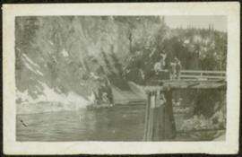
Photograph depicts lumber piles and what appears to be a very long sluicing trough along Otter Creek. Forest and hills in background. Handwritten annotation on verso of photograph: "Otter Creek 6/6/37". See also item 2009.5.2.70.
Switchback road, power lines and tramline towers are believed to be visible in the background valley. Construction of a long structure near the edge of the excavation area can be seen in midground; this is speculated to be the section of the crusher building which housed conveyor "B".
Image depicts what appears to be a junkyard for old mining equipment at an uncertain location, though possibly near Gibraltar.
Image depicts a group of people at a mine somewhere near Hazelton, B.C.
Photograph depicts buildings near West Peak of Cassiar mine. Haul trucks parked near old mine garage in background, new mine garage and unknown buildings in foreground. Mine valley crosses midground, expansive western mountain range in background.
File contains photographs featuring:
- the pit mine: fault line, geology, snowdrifts, plowed snow, blast patterns marked by orange cones, mist, and surrounding mountains.
- Pit mine is depicted by aerial photographs and a profile diagram.
- Several photographs also depict what is speculated to be the portal to the underground mine adit in the early phases of development.
- One photograph depicts the shop building in the pit mine, used for maintenance of mining equipment and to house the primary crusher.
- Several photographs show office interiors and personnel and it is speculated that these photographs were taken in the upper floor of the shop building.
- Several photographs depict small sinkholes in the pit mine.
- Mining equipment depicted includes pickup trucks, front end loaders (including a Cat 988), ore haulage trucks, scoop trams, D8 Caterpillar dozer, grader, mining drill rig, jumbo drill, rock hammer, P&H excavator, and wireline extensometer. Photolab envelopes accompanying these materials were annotated “R. Tyne” and “falling ground”. Slide sleeves were annotated “Mine Nov-Dec 1975”, “AERIAL SHOTS OF MINE 1976” and “Phase 8 Dec 1975”.
- Photographs of a Gardner Denver blasting drill at the mine and other ground drills working
- Photograph of proposed power line to #1 switchback in 1975,
- Collection of photographs of a Wsbco truck with corresponding mechanical transfers of those photographs.
- Also photographs a Gardner Denver drill and a Bucyrus Erie drill that was rented to Cassiar Mine in 1974. This collection includes a depiction of an accident with these drills.
- An additional collection of photographs of #709 Drill that was involved in minor accident. A pipe was either damaged or was the cause of the accident.
- Negative collection of photographs with corresponding notes of descriptions.
- Photographs of G.D. 80 Drill - Blasthole drill at work in the open pit.
- Photographs part of Month End Reports from January - June 1980
- Photographs of portable toilets used on Mine site.
- Photograph collection of mine garage January 21, 1988
- Photograph collection of what is believed to be the inside of the mine garage and various storage units and equipment. Marked "Receiver File" in original enclosure.
- Photos of Crane in 1984.
- An Album of 192 photographs of machinery in March of 1976 working at the mine site. Some of the equipment from either the plantsite or the mill is also depicted.
File contains photographs depicting machinery, individuals, buildings, and mining processes at the open mine on McDame Mountain, Cassiar, B.C. Some photos depict benches from open strip mining, and two images feature models of the mine (1955 and 1970). Machinery depicted includes shovels, bulldozers, tractors, ore haul trucks (Kenworth, International Harvester, and Wabco), air track drills, blasthole drills, and Ingersoll-Rand Drill. Identified individuals include Fred Murray, R.R. [Kiresan?], C.E. Bronson, Bill Giachino, and "Sam".
File consists of notes and reproductions relating to a heritage interpretative sign for the Millar Addition in Prince George. Includes: "RE: Millar Addition Sign" letter from the Borealis Creative Productions to Kent Sedgwick (28 June 1995). File also includes photographs depicting Fort George Park, a street view, and houses in the Millar Addition of Prince George (1995).
Image depicts a view of the Millar Addition suburb in Prince George, B.C.
Image depicts numerous trees on the bank of a river, possibly in Miles Canyon near Whitehorse, Y.T. The slide is labelled "canyon city."
Image depicts numerous unidentified individuals getting off a boat which bears the name "Schwatka." It is located somewhere in Miles Canyon.
Image depicts the Robert Lowe Bridge, built in 1922, in the Miles Canyon near Whitehorse Y.T.
Image depicts several unidentified individuals on a boat in the Miles Canyon near Whitehorse Y.T.
Image depicts a river in the Miles Canyon near Whitehorse Y.T.
Image depicts a river in the Miles Canyon near Whitehorse Y.T. The Robert Lowe Bridge, built in 1922, can be seen over the canyon.
Image depicts the river which runs through Miles Canyon, located near Whitehorse Y.T.
Image depicts a river at an uncertain location, but possibly in Miles Canyon near Whitehorse, Y.T.
Image depicts a stretch of land from Highway 97 at Mile 231, possibly near Clinton, B.C.
Image depicts the property of an old ranch at Mile 108 of Highway 97.
Image depicts Middle River by Trembleur Lake.
Image depicts the Meziadin Lake and the Bear Pass in the distance.
Image depicts the Meziadin Lake.
Image depicts the fish ladder of the Meziadin Falls, designed to help fish swim upstream.
Image depicts the Meziadin Falls in Meziadin Lake Provincial Park.
Image depicts several salmon somewhere in the Meziadin Lake Provincial Park.
Image depicts several individuals looking down into a closed off section of a river in Meziadin Lake Provincial Park. They are counting fish.
Photograph depicts large buildings on shore. Three unidentified individuals can be seen walking on dock in foreground.
Printed on image: "METLAKATLA B.C. / McRAE BROS"; handwritten annotation on verso reads: "A section of Metlakahtla, showing Church & Schoolhouse." See also item 2009.7.1.58 for similar image also featuring the new church building at Metlakatla, B.C.
Image depicts buildings in the village community of Metlakatla, B.C.
Image depicts Metlakatla, located near Prince Rupert, B.C.
Image depicts buildings in the village community of Metlakatla, B.C.
View of crusher building from above, featuring the bottom level foundation. A dirt road and long building believed to be housing conveyor "B" cross the midground. Valley in background.
Man standing on far left believed to be H.F. Glassey. One mam stands in military uniform. Hauling truck parked close behind plane, hill in left background.
Photograph depicts workers sitting in the back of a truck at the construction site for the Pacific Northern Gas pipeline from Summit Lake to Kitimat.
Photograph depicts men standing on different deck levels of conveyor in river. Wood planks built into shore in foreground, trees on opposite shore in background. It is speculated that this photo may have been taken near Tete Jaune Cache shortly after the conveyor was rebuilt. Handwritten annotation on verso of photograph reads: "Str. Conveyor".
Photograph depicts a line of men standing on rocky shore and holding a long rope between them, while men on scow float close to shore in distance. Trees on opposite shore in background. Handwritten photo caption on verso and recto of this photo reads: "in the Grand Canyon."
Photograph depicts a line of men standing on opposite shore and holding a long rope between them, while men on scow float close to shore in distance. River water in foreground, trees on shore in background. Handwritten photo caption on verso and recto of this photograph reads: "In the Grand Canyon."
Five unidentified men sit with dog in canoe. One man stands on dock in foreground.
Handwritten annotation on verso reads: "Freighting by canoe on skeena river".
Men working among lumber at crusher building site, various materials scattered throughout. Vertically protruding planks from framework of crusher building are in foreground. Tree-covered valley in background. Construction of a long structure near the edge of the excavation area can be seen in midground; this is speculated to be the section of the crusher building which housed conveyor "B".
Photograph depicts three men standing with oars in small boat, forest slash at their feet. More slash lies in foreground behind bushes and plants on swampy shore. Trees in background. These men are believed to be members of the Bourchier forestry crew.
Photograph depicts two unidentified men standing on wood walkway extended high above water. Cliffs in background. Photograph speculated to have been taken at Sayer Creek, B.C.
Photograph depicts two men beside the creek below the lake outlet at the proposed site for the hydro power project on Klemtu Lake.
Photograph depicts pipeline construction workers for the Pacific Northern Gas pipeline from Summit Lake to Kitimat with a helicopter on the north end of Prudhomme Lake.
Photograph depicts two men standing on mining bench in mountainside, three boxes and what appears to be a long hose to the left. Third man and tractor plow can be seen in distance at end of bench. Photo caption next to printed copy of image in 1953 Annual Report: "Benches being prepared for mining."
Photograph depicts two men working with air track drill in mine area. Hose and dynamite box in foreground, mountains in background. Handwritten annotation on verso of photograph: "Sept. 1954." This photograph was originally stored inside duotang labeled "CASSIAR ASBESTOS CORPORATION LIMITED PHOTOGRAPHS 1954"; photo caption beneath this image: "Starting New Bench at South end of Deposit."
Photograph depicts a memorial totem pole in front of a fence line and a forested environment. Inscription on memorial pole states: “In loving memory of Tlaqwa Latle of the Qidwasudinuk Tribe, Died Nov. 9 - ” Photographer’s stamp on verso: “W.E. Nicholson, 268 E. 10th, Vancouver 10, B.C.”
Image depicts a house with torn-up siding. The slide is labelled: "Mellos house relocated from Penny." The location is uncertain.
Photograph depicts McRae Creek Falls.
Photograph depicts McRae creek canyon.