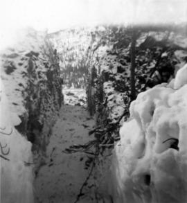
Photograph depicts high snow bank on right, side of tractor plow on left. Mountainside in background. Corresponding note on accompanying photo description page: "3. Plowing snow on road to mine. This location is just past the Upper Camp. Our TD-14 tractor to left."
Photograph depicts a cleared path through the snow and trees, mountain in background. Wood box and post semi-visible in foreground. Handwritten annotation in blue ink on recto of photograph: "You will notice we have a little snow here."
Photograph depicts snowy, cleared area bordered by dirt piles. Stakes visible in mid ground, trees and mountainside in background. Corresponding note on accompanying photo description page: "3. Survey stakes on power house site. Snow piles in background."
Handwritten annotation below photo on page taped to photograph: "PHOTO #2: Looking N across talus slide of asbestos fibre and serpentine fragments." Handwritten annotation on verso of photograph in blue ink describing sections of photograph which have been pointed to or outlined: "Talus of asbestos fibre & serpentine fragments -->" "Photo #1 -->" "Approx upper contact of serpentine -->".
Photograph depicts track loader moving dirt in semi-cleared area. Trees and mountains in background.
Photograph depicts track loader moving dirt in cleared area. It is believed that the loader may have been excavating area for ore haul truck dump (see item 2000.1.1.2.222). Trees and mountains in background.
Photograph was taken facing down a narrow, snowy trench, mountain base visible at end. Corresponding note on accompanying photo description page: "1. Trench through snow banks at mill site. We had to dig these trenches to facilitate surveying the mill foundations."
Image depicts Manson Creek, B.C.
File contains slides depicting places in and around Manson Creek.
Image depicts a man and his family filling up their truck with gas at Manson Creek, B.C.
Image depicts the gas station at Manson Creek, B.C.
Image depicts a creek with a half collapsed shack in the background somewhere in Manson Creek. The slide is labelled "Manson workings."
Image depicts the road to Manson Creek, B.C.
Photograph of the Prince Rupert wharf. Many vessels are docked next to small buildings along the water. Annotation on recto reads: "Prince Rupert BC."
File consists of research materials regarding Margaret Morse Nice, including photocopied letters, pamphlet by Margaret Morse Nice, and handwritten notes. File also contains a photo of Elizabeth M. Parnis and her CV.
Fonds predominately reflects Ainley's research as a professor at the University of Northern British Columbia. Her research is arranged into thirteen subseries. Research material includes: photocopies of publications and archival material, correspondence, bibliographies, research interviews, transcripts, draft manuscripts, photographs, and other records. A series of personal records includes: retirement activities, her hobbies of art and writing, diplomas, and photographs. The series on her administrative and supervisory activities of professorship of women’s studies and environmental studies is arranged according to the major activities with which Ainley was involved and includes: meeting minutes, memoranda, reports, correspondence, employment, and other records. A series of electronic records relating, predominately, to Ainley’s research includes: draft manuscripts, conference proceedings, bibliographies, transcripts, correspondence, curricula vitae and other records. A series of professional development records includes records from conferences she attended and occasionally presented at as well as other professional development activities that she undertook. A series of correspondence predominantly consists of personal correspondence but also includes professional correspondence related to her research and occupation.
Ainley, MarianneAnnotation on slide: "Marked-to-cut tree with old scar, Summit selection trial".
No annotation on slide.
Photograph depicts Mary John wearing flower print dress in cut field. Hay bales, trees, and fence in background.
Image depicts several houses in McBride, B.C. A mountain is visible in the background.
Image depicts a view of what is either the Rocky Mountains or possibly the Columbia Mountains from McBride, B.C.
Image depicts a view of what is either the Rocky Mountains or possibly the Columbia Mountains in the background of a small section of McBride, B.C.
File contains slides depicting places in and between McBride and the Yellowhead Pass via the Yellowhead Highway.
Image depicts the McBride Hotel near the Mt. Robson Provincial Park.
Image depicts a view of the Herrick River in what is possibly McGregor Canyon; the slide is simply labelled "McG above Canyon."
Image depicts a view of the Herrick River in what is possibly McGregor Canyon; the slide is simply labelled "McG Canyon."
Image depicts a view of the Herrick River in what is possibly McGregor Canyon; the slide is simply labelled "McG above Canyon."
Image depicts a view of the Herrick River in what is possibly McGregor Canyon; the slide is simply labelled "McG Canyon - above Herrick."
Image depicts the McGregor River at an uncertain location.
Image depicts what is possibly the McGregor River.
Image depicts the McGregor River at an uncertain location.
Image depicts a bridge over the McGregor River. A sign in the image reads: "Danger. The river is not navigable for any type of boat. Down stream falls and rapids impassible!"
Image depicts a bridge over the McGregor River.
Image depicts the McGregor from the point of view of a bridge.
File contains slides depicting the McGregor River and its surrounding areas.
Image depicts a view of McGregor Valley from an uncertain location.
Image depicts a view of McGregor Valley.
Image depicts a view of the McGregor Valley.
Image depicts a view of McGregor Valley.
Image depicts a view of McGregor Valley from an uncertain location.
Image depicts a view of McGregor Valley.