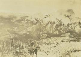
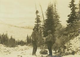
Photograph depicts hunting guides, Bruce Otto and Alex McDougall, standing next to a campfire with food in hand with a forest in the foreground.
Photograph depicts hunting guides, Alex McDougall and Bruce Otto, standing on top of a mountain peak searching for game. In the background a snow-covered mountain range is visible.
Photograph depicts hunting guides, Bruce Otto and Alex McDougall, searching for game from a snow covered valley with a forested area and mountains in the background.
Photograph depicts hunting guides, Bruce Otto and Alex McDougall, searching for game on mountain ridges from Terrace Creek. In the background of the image a forest and snow-covered mountain is visible.
Photograph depicts gulls at Lost Lagoon in Vancouver, B.C.
Image depicts a bridge in Hagwilget, B.C.
Image depicts a church on a hill in Hagwilget, B.C.
Close view of bridge built with wooden planks, poles, and wires, braced from below, with triangles built into its frame. The bridge crosses Hagwilget Canyon on the Bulkley River, five kilometres from its confluence with the Skeena River. This is one of the many bridge structures that have crossed this location since at least 1859. Photograph was taken from one side of canyon, near bridge. Opposite canyon wall in background. Typed annotation glued to verso of photograph: "HAGWILGET - 'the gentle or quiet people'."
Photograph depicts two men and a horse on a bridge built with wooden planks, poles, and wires, braced from below, with triangles built into its frame. The bridge crosses Hagwilget Canyon on the Bulkley River, five kilometres from its confluence with the Skeena River. This is one of the many bridge structures that have crossed this location since at least 1859. Photograph was taken from a distance. Rocky riverbank in foreground, opposite shore in background behind bridge. Typed annotation in red ink on verso of photograph: "INDIAN BRIDGE, NEAR HAZELTON, B.C."
Photograph depicts bridge built with wooden planks and poles, braced from below, with triangles built into its frame. The bridge crosses Hagwilget Canyon on the Bulkley River, five kilometres from its confluence with the Skeena River. This is one of the many bridge structures that have crossed this location since at least 1859.
Handwritten annotation on recto of photograph: "old bridge at the Bulkley River."
Photograph depicts the wooden Hagwilget Bridge spanning a rocky gorge over the Bulkley River. Forested area visible in the background. Annotation on recto of photograph states: "W.W.W. Old Indian Bridge, Bulkley River"
File contains slides depicting places on Haida Gwaii, formerly known as the Queen Charlotte Islands.
Image depicts Haldi Lake near Prince George, B.C.
Image depicts a house on Blackwater Road.
View of 5 buildings and 4 tents on land that has been cleared to stumps. Printed annotation on verso reads: “HAMILTON AVE. FORT GEORGE”, added handwritten annotation in ink reads: “1910”.
Image depicts a hammer sitting in dirt at an uncertain location.
Image depicts the new Hansard Bridge. Map coordinates 54°04'57.9"N 121°51'10.1"W
Image depicts the Hansard railroad bridge taken from the new Hansard vehicle bridge. Map coordinates 54°04'58.1"N 121°50'58.0"W
Image depicts a road leading into a First Nations' Reserve at the head of Harrison Lake.
Annotation on slide: "Harry Coates with Sw seedlings planted spring of 1991, SBSwk1, Note chlorotic seedlings"
Photograph depicts Harry Coates, Ted Baker, and John Revel at Aleza Lake Research Forest re-opening ceremony on July 9, 1992.
Photograph depicts Harry Snyder with three wagons and horse teams coming into Hudson's Hope from Portage. In the background three small buildings are visible in front of a forested area.
Image depicts the road leading to the historic Hat Creek Ranch site north of Ashcroft, B.C. Several individuals are sitting on the front porch of the Ranch house.
Photograph of a large wooden bridge across Hayes Creek, Prince Rupert, BC. Printed annotation on recto reads: "Hayes Creek Bridge Prince Rupert BC." Handwritten annotation on recto reads: "Dear Mary. Why don't you and my letter hyp[illegible] old [illegible] Louisa A./ P.O. Box 32./ P.R." Handwritten address on verso reads: "Miss Mary Wonoghue Prideaux St., Nanaimo. B.C." Postcard is affixed with a one cent Canadian stamp. Postmarks on verso read: "Prince Rupert B.C. PM Jun 18 11." and "Nanaimo B.C. 18 Jun 21 11."
Image depicts Hazelton, B.C.
Image depicts a beaver dam somewhere in Hazleton, B.C.
Image depicts the cemetery in Hazelton, B.C.
Image depicts a tombstone in the cemetery in Hazelton, B.C.
Image depicts the cemetery in Hazelton, B.C.
Image depicts the canoe group around a campfire at the head of Indianpoint Lake.
Image depicts the head of Lillooet Lake.
Slide depicts a man operating heavy equipment in a forest, likely at the Aleza Lake Experiment Station.
Image depicts a piece of heavy machinery lifting numerous logs off the back of a logging truck. It is likely located in Prince George, B.C.
Image depicts a piece of heavy machinery lifting numerous logs. It is likely located in Prince George, B.C.
Annotation on slide: "Heavy Residual Basal Area: Summit Lake".
Image depicts what is possibly either the Hecate Strait or Minette Bay from somewhere near Kitimat, B.C.
Image depicts the Hecate Strait near Prince Rupert, B.C.
Image depicts the waters of the Hecate Strait.
Image depicts the waters of the Hecate Strait, possibly on approach to Haida Gwaii, B.C.
Image depicts the Hecate Strait near Prince Rupert, B.C.
Image depicts what is possibly either the Hecate Strait or the Minette Bay from somewhere near Kitimat, B.C.
Image depicts a man standing in front of a helicopter; a waterfall is visible on the cliffs in the background. The slide itself is labelled "BC Parks Tour."
Photograph depicts crusher plant in centre foreground. Shifter shack and vehicles can be seen in front of pit area. West Peak semi-visible in right midground. Mine valley an northwestern mountain range in background.
Photograph depicts the West Peak of the Cassiar mine on McDame Mountain. Pit area visible between West Peak and road in foreground. Mine valley and north mountain range in background. Photo speculated to have been taken from a point on or near the South or North Peak.
Photograph depicts mine valley and road in foreground. Cassiar plant and tailings pile visible in left midground, townsite in right midground. Mountainside of McDame Mountain in foreground, southern mountain range in background.