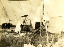
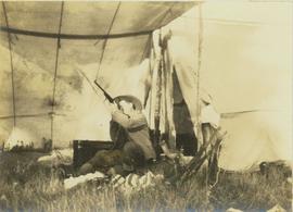
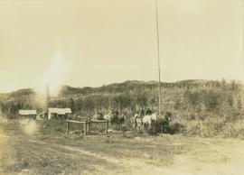
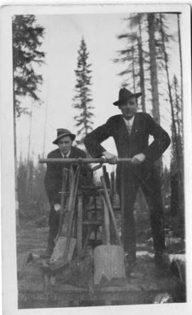
Photo depicts two men on a hand car: handwritten descriptor with photo reads: "Hand car photo, Chicken Lake (now Lake Kathlyn just west of Smithers on CN mainline; was the Grand Trunk Pacific ice house. Sunday March 14th, 19__."
Photograph depicts a hand car at the Fort Steele Railway Museum. Built by Fairmont of Canada.
Photograph depicts a hand car owned by the Kettle Valley Steam Railway. Behind it was a Woodings inspection car.
Photograph depicts the hand truck and track material at Tilbury, Delta in the Fraser Valley. It belongs to the Canadian National Railway (CN)
Image depicts a man and woman shaking hands in a building at an uncertain location, possibly in Cottonwood Park. The man standing behind the two is possibly Elmer Mercier, a former mayor of Prince George, B.C.
Photograph depicts some stumps and grassland in the foreground, a few buildings on the right, sparsely forested rocky hillside in the background.
Photograph depicts a building that was believed to have had many usess, its last being a fish store.
Photograph depicts Hanford Woods, author of "The Drubbing of Nesterenko and First Loves".
Photograph depicts Hanford Woods at bat.
Photograph depicts Hanford Woods' wife.
Photograph depicts an exterior view of a hangar at the Edmonton Airport surrounded by four airplanes and three automobiles.
Photograph depicts Hans Fenger and Jayne Duncan at the wedding of Brian Fawcett and Nancy Boyd.
Photograph depicts Hans Fenger and Victoria Wagner at the wedding of Brian Fawcett and Nancy Boyd.
File consists of notes and reproductions relating to Hansard, a community along the East Line. File contains material regarding the community and the building of a railway bridge over the Fraser River at Hansard. File also includes photographs depicting the new Hansard bridge (2005).
Image depicts the new Hansard Bridge. Map coordinates 54°04'57.9"N 121°51'10.1"W
Caption describing photograph: "Hansard Ferry"
Image depicts the Hansard railroad bridge taken from the new Hansard vehicle bridge. Map coordinates 54°04'58.1"N 121°50'58.0"W
Image depicts the Hansard railroad bridge looking west. Map coordinates 54°04'37.9"N 121°50'46.3"W
Photograph depicts Happy and Missy the dogs at Fawcett property in Penticton.
View of building, dock, harbour and small islands with snow peaked mountains in background. Printed caption on verso reads: “Port Essington B.C. Photo by P. E. Fisher”. Handwritten annotation in ink on verso reads: “up the Skeena”, in pencil on verso: “Port Essington, North Coast Commercial Coy”.
Boats, docks, ships and a large building in waterscape. Printed annotation on recto reads: “Prince Rupert B.C.” Handwritten annotation in pencil on verso reads: “McRae Bros”.
Elevated view of the buildings along the Prince Rupert shore, including the Prince Rupert Inn. The waterfront and some small islands can be seen in the background. Printed annotation on recto reads: "Harbour, Prince Rupert, B.C. 1658."
Photograph depicts Coal Harbour in Vancouver. The photo is facing land fill with stone on the tidal side. The site is for the first block of the Harbour Park Development Ltd. high rise apartments.
Photograph depicts the Harbour Park Development site in Coal Harbour, Vancouver. Taking rock from the scow to face fill with anti-erosion material. The site is for new high rise apartments at the edge of Stanley park between Georgia St. and the sea.
Photograph depicts a harbour seal. Davies' sailboat is in the foreground.
Photograph depicts a harbour seal diving into the water after sunning on a boom log. The bow of Davies' sailboat is in the foreground.
Caption describing photograph: "Hardwood stand on Lacustrine deposits following severe burn, negligible coniferous understory. 1922 burn N side Eaglet Lake. Aspen with scat Birch +/-20 yrs. +/-6 D.B.H. +/-35'. Understory willow and alder, twin flower R O Dogwood Rose H B Cranberry, scat sorylus, rubus, was A-D S-B site."
Photograph depicts the Hardy Bay pier. Handwritten annotation below the photograph reads, "Hardy Bay. Vancouver Island".
Image depicts a road leading into a First Nations' Reserve at the head of Harrison Lake.
Fonds consists of records Harry Coates created or received and retained during his career as a BC Forest Service Research Technician and into his retirement as a Sustainable Forest Management activist. Fonds includes materials from his work at the Aleza Lake Research Forest.
Coates, HarryPhotograph is a copy print.
Annotation on slide: "Harry Coates with Sw seedlings planted spring of 1991, SBSwk1, Note chlorotic seedlings"
Photograph depicts Harry Coates, Ted Baker, and John Revel at Aleza Lake Research Forest re-opening ceremony on July 9, 1992.
Handwritten annotation on recto of photo reads: "Harry Monson Edmonton Prince George." Harry reclines on bed under window, surrounded by personal effects. Photograph was taken after nightfall. Handwritten caption beside this photo reads: "Harry talked my dad into selling him my boat".
Photograph depicts Harry Snyder (left) and Carrol Paul (right) seated side by side on a log with a low wooden building in the background.
Photograph depicts Harry Snyder sitting under a tent cleaning his rifle. In the background behind Snyder are several boxes and a man standing with his back to the camera.
Photograph depicts Harry Snyder sitting under a tent cleaning a rifle with two other rifles resting beside him.
Photograph depicts Harry Snyder sitting under a tent sighting his newly cleaned rifle with two other rifles leaning beside him.
Photograph depicts Harry Snyder with three wagons and horse teams coming into Hudson's Hope from Portage. In the background three small buildings are visible in front of a forested area.
Image depicts Glenview Drive near the Hart Highway in Prince George, B.C.
Photograph depicts Hart Gardner. Handwritten annotation on verso of photograph reads, "Hart Gardner".
File contains slides depicting places along the Hart Highway.
Image depicts a neighbourhood on the Hart Highway in Prince George, B.C.
The item is a photograph depicting the weathered Hart Highway schoolhouse. The school is shown at its relocation to the Myatovic farmland. Annotation on reverse side of photograph states, "east building s. end looking NE - from Hart Hwy."
The item is a photograph depicting the weathered Hart Highway schoolhouse. The school is shown at its relocation to the Myatovic farmland. Annotation on reverse side of photograph states, "east building, n. end, view se." Accompanying note with photograph states, "Shady Valley relocation to Myatovic farm property."
The item is a photograph depicting three weathered schoolhouses lined next to each other. The schools are from Hart Highway, Shady Valley, and Westlake. They are shown at their relocation to the Myatovic farmland. Annotation on reverse side of photograph states, "Myatovic property, N side looking west - left - Hart Hwy, Mid - Shady V, right - West L."