Showing 1363 results

Archival description
936 results with digital objects Show results with digital objects
2011.3.3.20 · Item · [ca. 1910]
Part of North Coast & Central BC Postcard Collection

View of fish boat in water, with net spread and smaller boat on opposing side of net. Several gulls can be seen flying in the air. Rail cars town and treed hills in background. Printed annotation on recto reads: “Herring Fishing In Prince Rupert Harbour McRae Bros.” Handwritten message in ink on verso is addressed to “Mr. H. Smart 2550 Blackwood St. Victoria B.C.”

2009.7.1.133 · Item · [ca. 1910?]
Part of Archdeacon W. H. Collison fonds

Photographs depict groups of men gathered on ice. Herbert leans over behind two friends seated on ice sled (son of Marion and Archdeacon W.H. Collison). Pile of caught fish can be seen in foreground behind large whole in ice.

Handwritten annotations on verso read: "Oolichan Fishing Fishing Bay Nass River"; "Uncle Herbert with Indian friends fishing for oolichan through the ice."

2000.1.1.3.19.101 · Item · [ca. 1975]
Part of Cassiar Asbestos Corporation Ltd. fonds

Photograph depicts the West Peak of the Cassiar mine on McDame Mountain. Pit area visible between West Peak and road in foreground. Mine valley and north mountain range in background. Photo speculated to have been taken from a point on or near the South or North Peak.

2005.3.63 · Item · [ca. 1946]
Part of John Hart Highway Photograph Collection

Handwritten annotation on recto of photo reads: "Harry Monson Edmonton Prince George." Harry reclines on bed under window, surrounded by personal effects. Photograph was taken after nightfall. Handwritten caption beside this photo reads: "Harry talked my dad into selling him my boat".

2011.3.1.02 · Item · [ca. 1905]
Part of North Coast & Central BC Postcard Collection

View of building, dock, harbour and small islands with snow peaked mountains in background. Printed caption on verso reads: “Port Essington B.C. Photo by P. E. Fisher”. Handwritten annotation in ink on verso reads: “up the Skeena”, in pencil on verso: “Port Essington, North Coast Commercial Coy”.

2009.7.1.268 · Item · 28 September 1920
Part of Archdeacon W. H. Collison fonds

Photograph of a partially sunken sailboat near a harbour. Individuals on debris and in a rowboat are surveying the damage. Annotation on recto reads: "GTP. SS Prince Rupert Sept 28th 1920 McRae." Handwritten annotation on verso reads "CTP "Prince Rupert" Sunk at Prince Rupert BC 1920."

Grizzly Bear
2005.3.52 · Item · [ca. 1945]
Part of John Hart Highway Photograph Collection

Handwritten caption below this photo reads: "Bought in Picture Prince George". Photograph depicts a grizzly bear walking on all fours in forest area, slash debris in background.

Gravel Pit
2000.1.1.3.18.013 · Item · June 1987
Part of Cassiar Asbestos Corporation Ltd. fonds

Photograph depicts close up view of gravel pit, ruler displayed for scale. Photograph speculated to have been taken at the plant or near the Cassiar airstrip. Stamped annotation on recto of photograph: "JUN. 1987".

Grand Trunk Pacific
2000.23.1.053 · File · 1968-1985
Part of Audrey Smedley L'Heureux fonds

File consists of collected research materials regarding the Grand Truck Pacific Railway. Materials include brochures, newspaper clippings, a CN supplement, a bibliography, pamphlets, correspondence, photographs, and reproductions of articles. Highlights include:

  • Fraser Fort George Museum, "Grand Truck Pacific: The Transcontinental Line", 1983 (exhibit brochure)
  • CN Mountain Region Supplement 1 employee time table for June 21, 1978
  • CN Headquarters Library, "A Selected Bibliography on Canadian Railways", Special Series No. 25 6th edition, 1968
  • Greater Victoria Public Library, "Railroads & Railroading in Canada: A selected booklist", 1988 (pamphlet)
  • Stephen Ruttan, "Transportation in British Columbia", 1985 (pamphlet)
  • Fort George Regional Museum, "Fort George Railway, Prince George B.C.", [198-?] (pamphlet)
  • Bulkley Valley Historical and Museum Society, "Smithers Grand Trunk Pacific Freight and Passenger Division Headquarters", 1978 (booklet)
  • Prince George Railway Museum, "On Track" newsletter, Vol. 9 No. 6-7 July, 1991 (newsletter)
  • Central British Columbia Railroad Preservation and Museum Society, "On Track" newsletter, Vol.3 No.5 1985 (newsletter)
  • BC Provincial Archives of British Columbia Aural History Programme, "The Grand Trunk Pacific", Interviewed by Imbert Orchard, People in Landscape Educational Series, 1969 (booklet)
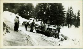
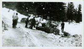
  • Reproduction of BC Archives photograph depicting the Grand Trunk Pacific Railway entitled "Camp near Burns Lake", Aug 1912
  • Reproduction of BC Archives photograph depicting the Grand Trunk Pacific Railway entitled "G.T.P. Steel bridge across the Shuswap River, Mile 79, 12 miles east of McBride", [191-?]
  • Reproduction of BC Archives photograph depicting the Grand Trunk Pacific Railway entitled "Prairie Creek Bridge nearly completed, 5 miles west of Hilton", [191-?]
  • Reproduction of BC Archives photograph depicting the "McKenzie & Blais store", [191-?]
  • Reproduction of BC Archives photograph depicting the Grand Trunk Pacific Railway entitled "Linking up of Steel on G.T.P. Transcontinental, Fort Fraser", 1914
2011.12 · Collection · September 1950 - June 1951

This photograph collection consists of 53 photographs featuring primarily Giscome with a few of Prince George. Subjects include the Eagle Lake Sawmill, Eagle Lake, Giscome townsite (including specific buildings and general road perspectives), Giscome School, Division II class photos (1950-51), and the Giscome School teacherage.

Giscome Sawmill
2012.13.1.87.167 · Item · [between 1975 and 1995]
Part of J. Kent Sedgwick fonds

Image depicts the mill site at Giscome, B.C. Map coordinates 54°04'19.7"N 122°22'04.7"W

Giscome Sawmill
2012.13.1.87.171 · Item · [between 1975 and 1995]
Part of J. Kent Sedgwick fonds

Image depicts the mill site at Giscome, B.C. A sign in the foreground reads "Maynard's Industrial Auctioneers." Map coordinates 54°04'19.7"N 122°22'04.7"W

Giscome Sawmill
2012.13.1.87.168 · Item · [between 1975 and 1995]
Part of J. Kent Sedgwick fonds

Image depicts the mill site at Giscome, B.C. Map coordinates 54°04'19.7"N 122°22'04.7"W

Giscome Sawmill
2012.13.1.87.170 · Item · [between 1975 and 1995]
Part of J. Kent Sedgwick fonds

Image depicts the mill site at Giscome, B.C. Map coordinates 54°04'19.7"N 122°22'04.7"W

Giscome Sawmill
2012.13.1.87.169 · Item · [between 1975 and 1995]
Part of J. Kent Sedgwick fonds

Image depicts the mill site at Giscome and its beehive burner. Map coordinates 54°04'19.7"N 122°22'04.7"W

2012.13.1.87.086 · Item · [between 1980 and 2000]
Part of J. Kent Sedgwick fonds

Image depicts the Giscome mill site in Giscome, B.C. The bunkhouse is the large building with many windows. A train and railroad tracks are in the foreground. Map coordinates 54°04'17.6"N 122°22'06.1"W

Giscome - Power Poles
2012.13.1.87.098 · Item · [between 1975 and 1995]
Part of J. Kent Sedgwick fonds

Image depicts the remains of a street of houses in Giscome, B.C. The quarry is slightly visible in the background. Map coordinates 54°04'20.9"N 122°21'53.1"W