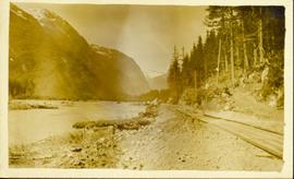
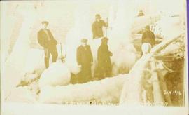
Image depicts two merging railway tracks, and what appears to be a frozen river, somewhere near the summit of a mountain.
Photograph of a stretch of railroad passing by a small body of water. Mountains are visible in the background.
Photograph depicts winter landscape with track and logs in foreground. Bridge, trees and cleared land in background.
Image depicts a man and woman standing in the mouth of a tunnel from the old Kettle Valley Rail Road.
Image depicts the mouth of a tunnel from the Kettle Valley Rail Road.
Image depicts an unknown figure standing inside a tunnel from the old Kettle Valley Rail Road.
Image depicts a tunnel from the old Kettle Valley Rail Road.
Image depicts a woman standing inside a tunnel from the old Kettle Valley Rail Road.
Image depicts the mouth of a tunnel from the Kettle Valley Rail Road.
Image depicts rail road tracks west of Takla Landing.
Image depicts a rail road construct from Highway 97 at Mile 126; the slide is also labelled "McAlister."
Annotation on slide: "20 cm radial growth on released subalpine fir, Summit Lk trial".
Image depicts Kent Sedgwick standing in front of a sign with a dog in Quesnelle Forks, B.C. The sign describes the history of the site, which began as a mining camp in 1859, but was later completely abandoned after a fire in 1866. It is now managed as a Forest Service Recreation Project.
Image depicts the forest surrounding Quesnelle Forks.
Image depicts a dirt road and power-lines running through the woods, possibly near Quesnelle Forks.
Image depicts a collapsed wooden structure, possibly a bridge, which is likely located somewhere near Quesnelle Forks.
Image depicts an old building which has collapsed into a pile of wood, possibly in Quesnelle Forks.
Image depicts numerous abandoned and ruined cabins at Quesnelle Forks.
File contains slides depicting Quesnelle Forks, B.C.
Image depicts numerous old and ruined cabins in Quesnelle Forks.
Image depicts numerous wood piles near the sawmill somewhere in Quesnel, B.C.
Image depicts a sawmill somewhere in Quesnel, B.C.
Image possibly depicts the Fraser River from Highway 97 near Quesnel, B.C.
Image depicts the Fraser River from Highway 97 near Quesnel, B.C.
Image depicts Quadra Ventures Industrial Lodge in Tumbler Ridge, B.C.
Image depicts an old, pyramid shaped wooden frame somewhere near Miworth, B.C.
Photograph taken at Government House, Victoria, B.C.
Image depicts a pulpmill, likely Northwood, in Prince George, B.C.
Image depicts the flows from a pulp mill in Prince George, B.C.
Conveyor sits on tall steel framework, encased in steel sheeting, and stands to right of snow-covered slope. Propane tank sits on log structure below conveyor. Snowy mountains in background. See also item 2000.1.1.2.373. Handwritten caption below this photo reads: "Project completed - at 52˚ temp."
Photograph depicts a profile view of a pack horse laden with Prentiss Gray's camera equipment.
Photograph taken at Government House in Victoria, B.C.
Photograph of a small vessel on the ocean with a dock and harbour buildings in the foreground. Tents and piles of lumber can be seen among the buildings. Annotation on recto reads: "The Wharf, Prince Rupert, BC. 1657." Printed annotation on verso reads "The Wharf, Prince Rupert, BC J. Howard A. Chapman, Victoria. BC. 1657."
Photograph of the Prince Rupert wharf. A small vessel is docked, and a large tree is in the foreground. Annotation on recto reads: "Prince Rupert Wharf & Harbor. Allen Photo." Handwritten annotation on verso reads: "766[?]"
Photograph of the Prince Rupert wharf. A small vessel is docked, and a large tree is in the foreground. Annotation on recto reads: "Prince Rupert Wharf & Harbor. Allen Photo."
Photograph depicts the tops of trees and sky with an unknown man's head at the Prince Rupert Sea Festival.
Photo of entire ship building plant, including several vessels in the foreground. Hills are visible in the background. Annotation on recto reads: "Prince Rupert Ship Repair and Ship Building Plant. Prince Rupert BC. Frank E Kirby, William T Donnelly, Engineers. 17 Battery Place. NYC."
Image depicts a view of the port in Prince Rupert, B.C. The slide is labelled "superport."
Wide angle photograph of Prince Rupert sometime during the winter. There is snow on the ground and a marge mountain range is visible in the background. Annotation on recto reads: "Prince Rupert looking East from Waterworks J.D.A Pho 5/2."
Photograph depicts 6 Men on a fishing boat with water in the background. Equipment on the boat is covered with a very thick layer of ice. Printed annotation on recto reads: “Rupert Fishing Boat After Stormy Trip Jan 1916”. Handwritten annotation in pencil on verso reads: “Rupert Fishing Boat , A Stormy Trip”.
Image depicts a view of what is possibly a shipping yard in Prince Rupert, B.C. The slide is labelled "superport."
Image depicts numerous houses on the cliff-sides in Prince Rupert, B.C.
Image depicts numerous buildings and a small dock somewhere in Prince Rupert, B.C. One of the buildings is labelled "Fishermen's Supply."