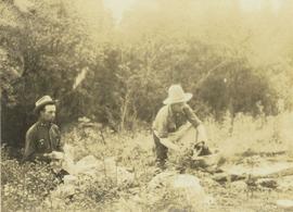
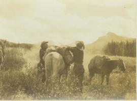
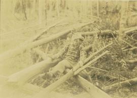
Photograph depicts men on river boat and small canoe floating just off shore. Men sit and stand on shore among square bales and large cut lumber. Forest in background. Handwritten annotations on recto of photograph: "Fort Fraser wooding up at Giscome Portage", "Chilco at Giscome Portage".
Image depicts a forestry cabin located in Tête Jaune Cache, B.C.
Image depicts the former location of employee houses on mill site in Giscome, B.C. Map coordinates 54°04'23.4"N 122°22'16.9"W
Image depicts the former location of the Giscome mill foreman's house on the hill with Eaglet Lake in the background. Map coordinates 54°04'28.0"N 122°22'05.8"W
Image depicts Fort George Canyon.
File contains slides depicting images of the Fort George Canyon from 1984.
Image depicts the Fort George Par, which was renamed Lheidli T'enneh Memorial Park in 2015. Map coordinates 53°54'30.2"N 122°43'57.4"W
Image depicts an aerial view of Fort George Park.
Image depicts Stuart Lake in Fort St. James, B.C.
Image depicts a partially frozen lake, most likely Stuart Lake in Fort St. James, B.C.
Image depicts a lake, possibly Stuart Lake in Fort St. James, B.C.
Image depicts a view of Fort St. John, B.C.
Image depicts an area of forests and fields somewhere near Fort St. John, B.C.
Image depicts a view of Fort St. John, B.C.
Image depicts numerous unknown individuals searching through a fossil bed, possibly in the Bulkley Valley.
Image depicts a fossil bed, possibly somewhere in the Bulkley Valley.
Photograph is one of 13 images printed from digital format on a CD-R featuring members of a group referred to as 'Terracites' (see item 2009.6.1.697) pictured in the gardens; see also items 2009.6.1.698 - 2009.6.1.710.
Image depicts four hikers putting on rain parkas.
Photograph depicts group of men and a lap dog sitting on a log in the bush. Men wear suits and hats.
Handwritten photo caption below image reads: "Max Lohbrunner" (believed to be man on right).
Image depicts four unknown individuals studying a plant.
Image depicts Francois Lake.
Image depicts a view of Francois Lake.
Image depicts a section of land on the east end of Francois Lake. The lake is visible in the distance.
Image depicts the Nadina Delta at Francois Lake.
Image depicts a view of the forest surrounding Francois Lake.
Photograph depicts Frank Dewing to the left and Elmer Keith on the right washing dishes in camp. In the background a densely forested area is visible.
Photograph depicts Frank Dewing and Joe Callao in a bush covered field loading up a pack horse while another laden pack horse stands to the side. In the background a mountain range is visible.
Photograph depicts Frank Dewing and Joe Callao loading up a pack horse in a grassy field. In the background a mountain range is visible.
Photograph depicts Frank Dewing and Joe Callao next to a campfire in a bush covered field. In the background the tree line of a forest is visible.
Photograph depicts Frank Dewing and Joe Callao next to a campfire with travel packs in the foreground. In the background a forest tree line and mountain range is visible.
Photograph depicts Frank Dewing cutting a trail through an area covered with windfall consisting of fallen trees.
Image depicts the Fraser Lake.
Image depicts a view of the Fraser Lake.
Image depicts the Fraser Lake.
Image depicts Sue Sedgwick by the Fraser Lake.
Image depicts a view of Fraser Lake.
Image depicts a canoe on the Fraser Lake.
Image depicts a view of the Fraser Lake from the Fraser Lake campsite.
Image depicts a view of the Fraser Lake skyline.
Image depicts what is possibly either the Fraser or Chilcotin River.